
Rio Grande National Forest facts for kids
Quick facts for kids Rio Grande National Forest |
|
|---|---|
,_Colo.jpg)
Stony Pass jeep road, east of Silverton, Colorado. Spectacular scenery along this old wagon road over Stony Pass (12,588 feet), at the edge of the Weminuche Wilderness
|
|
| Location | Colorado, United States |
| Nearest city | Alamosa, CO |
| Area | 1,860,000 acres (7,500 km2) |
| Established | July 1, 1908 |
| Governing body | U.S. Forest Service |
| Website | Rio Grande National Forest |
The Rio Grande National Forest is a huge natural area in southwestern Colorado, USA. It covers about 1.86 million acres. That's like 7,530 square kilometers, or more than 2.5 million football fields!
This forest is home to the San Luis Valley. This valley is special because it's one of the biggest farming valleys in high mountain areas. It also has one of the world's largest high deserts near mountains. The famous Rio Grande river starts its journey right here in the forest. Also, the Continental Divide runs along most of its western edge. The Continental Divide is like a big line on mountains. It separates which way rivers flow, either to the Atlantic or Pacific oceans.
The forest spreads across parts of nine different counties in Colorado. These include Saguache, Mineral, Conejos, Rio Grande, Hinsdale, San Juan, Alamosa, Archuleta, and Custer counties. The main office for the forest is in Monte Vista, Colorado. Soon, it will move to Del Norte. You can also find smaller ranger offices in Del Norte, La Jara, and Saguache. These offices help manage and protect the forest.
Contents
Exploring the Rio Grande National Forest
The Rio Grande National Forest is a fantastic place for outdoor adventures. It offers many activities for visitors. You can go hiking, camping, fishing, and wildlife watching. In winter, there are opportunities for skiing and snowshoeing.
What Makes the Forest Special?
The forest has diverse landscapes. You'll find tall mountains, deep valleys, and wide-open spaces. It's a mix of thick forests and high deserts. This variety makes it a home for many different plants and animals.
Wilderness Areas: Protected Nature
Within the Rio Grande National Forest, there are four special places called wilderness areas. These areas are part of the National Wilderness Preservation System. This system protects wild lands so they stay natural and untouched. People can visit these areas, but they must leave no trace. This means no roads, buildings, or machines are allowed.
Some of these wilderness areas also stretch into other nearby National Forests or even National Park Service land.
- La Garita Wilderness: Most of this area is in the Gunnison National Forest.
- Sangre de Cristo Wilderness: The largest part of this wilderness is in the San Isabel National Forest. It also touches Great Sand Dunes National Park and Preserve.
- South San Juan Wilderness: Part of this area is in the San Juan National Forest.
- Weminuche Wilderness: Most of this wilderness is also in the San Juan National Forest.
These wilderness areas are important for protecting nature. They allow animals to live freely and plants to grow naturally. They also offer a chance for people to experience true wildness.
Climate and Weather in the Forest
The Rio Grande National Forest experiences a type of climate called a warm-summer humid continental climate. This means it has warm summers and cold, snowy winters.
The weather can change a lot. The hottest temperature ever recorded at the Rio Grande Reservoir was 89 degrees Fahrenheit (32 degrees Celsius). This happened on July 6, 1989, and again on July 14, 2003. The coldest temperature recorded was a very chilly -46 degrees Fahrenheit (-43 degrees Celsius) on December 8, 1978.
The forest gets a good amount of snow, especially in winter. This snow helps feed the rivers and streams when it melts in the spring.
Images for kids
-
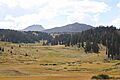
Mountains in Rio Grande National Forest in September 2013
-

The Continental Divide of the Americas separates the Rio Grande National Forest and the San Juan National Forest


See also
 In Spanish: Bosque nacional del Río Grande para niños
