
San Luis Valley facts for kids

The San Luis Valley is a large area in south-central Colorado, with a small part reaching into New Mexico. The Rio Grande river, which starts in the San Juan Mountains, flows through this valley and then south into New Mexico. The valley includes six counties and parts of three others.
The United States gained the San Luis Valley from Mexico after the Mexican–American War. Later, Hispanic settlers moved north into the valley after the U.S. made a treaty with the Utes and built a fort. Before the war, the Spanish and Mexican governments had kept the valley for the Utes, who were their friends. In the 1800s, Anglo settlers also came to the valley. They worked in mining, ranching, and farming. Today, the valley has many different people, both Anglo and Hispanic.
This valley is a big, high-up basin, like a large bowl, covering about 20,700 square kilometers (8,000 square miles). Its average height is about 2,336 meters (7,664 feet) above sea level. The valley is part of the Rio Grande Rift, a long crack in the Earth's crust. The Rio Grande river drains the valley to the south. The valley is about 196 kilometers (122 miles) long and 119 kilometers (74 miles) wide. It stretches from the Continental Divide in the northwest down into New Mexico. The San Luis Valley has a cold desert climate, but it has a lot of water from the Rio Grande and from underground sources.
Contents
History of the Valley
Early People: The Utes
Before 1868, the Capote (Kapota) group of Ute Native Americans lived in the San Luis Valley. The Utes made a peace treaty with the United States in 1849, after the Mexican War. Soon after, settlers from New Mexico started building small towns in what is now Colorado. In 1868, the Utes were moved to a special area called a reservation in western Colorado.
Spanish and Mexican Times
This area was once part of a Spanish, and later Mexican, region called Nuevo Mexico. It became part of the United States in 1848 after the Mexican–American War. This change happened because of a peace agreement called the Treaty of Guadalupe Hidalgo.
United States Takes Over
Many people started settling in the San Luis Valley in the 1850s. Most of these early settlers were Hispanic farmers and ranchers from New Mexico. They built a church in the village now called San Luis in 1851. Today, the San Luis Valley has the largest group of native Hispanic people in Colorado. Many families are direct descendants of those first settlers.
More people moved in after the U.S. Army built Fort Massachusetts. This fort was built to protect settlers from the Utes, who had stopped people from settling there before. The story of the U.S. military in the valley is kept alive at Fort Garland and other historic places.
The San Luis Valley became part of the Territory of Colorado in 1861. The original Ute people were later moved to the Southern Ute and Ute Mountain reservations in the late 1800s.
- The San Luis Valley was one of eight places considered for exploding the first atomic bomb. The Trinity (nuclear test) ultimately happened at White Sands Proving Ground.
Geography of the Valley
The San Luis Valley is a wide, mostly flat valley where the Rio Grande river begins. It is in south-central Colorado and northern New Mexico. The northern part of the valley is a closed basin, meaning water here does not flow out to the ocean. Farming is possible because of underground water and streams fed by the large amount of snow (about 254 centimeters or 100 inches) that falls in the surrounding mountains. The southern part of the valley is drained by the Rio Grande.
The valley is about 80 kilometers (50 miles) wide from east to west and about 240 kilometers (150 miles) long from north to south. The Sangre de Cristo Mountains are on its east side, and the San Juan Mountains are on its west side.
In Colorado, the San Luis Valley includes six counties: Saguache, Alamosa, Rio Grande, Conejos, Costilla, and Mineral. Some of the main towns are Alamosa, Monte Vista, Del Norte, and San Luis.

Blanca Peak is a very tall mountain in the Sangre de Cristo Range. Several mountain passes, between 2,743 and 3,048 meters (9,000 and 10,000 feet) high, allow access to the valley. U.S. Highway 160 and the San Luis and Rio Grande Railroad use La Veta Pass. Other passes used in the past include Medano, Mosca, and Sangre de Cristo Passes.
The Great Sand Dunes are a famous natural wonder in the valley. They are right next to the Sangre de Cristo Mountains and can be as tall as 229 meters (750 feet). The Great Sand Dunes National Park and Preserve protects these dunes and many old archaeological sites. The natural underground water source is close to the surface here, helping to keep the water levels in the San Luis Lakes stable.
As you go north in the valley, the elevation rises to Poncha Pass. U.S. Highway 285 uses this pass today. In the 1800s, Otto Mears built a toll road over Poncha Pass. This road was important during Colorado's mining boom.
Cumbres Pass is 3,053 meters (10,015 feet) high, located between Antonito, Colorado and Chama, New Mexico. State Highway 17 and the Cumbres and Toltec Scenic Railroad cross this pass. Wolf Creek Pass is used by U.S. Highway 160 between Del Norte, Colorado and Pagosa Springs, Colorado.
The Rio Grande river flows through the southern valley from Del Norte southeast to Alamosa and then into New Mexico. South of Alamosa, other streams join it, like the Alamosa River and the Conejos River. Most of the northern valley is a closed basin. Here, major streams like Saguache Creek and San Luis Creek flow only a short distance onto the valley floor. Only in very wet years, perhaps every 20 years, does the water in the closed basin flow all the way to San Luis Lake.
Land Ownership

About half of the 809,371 hectares (2,000,000 acres) in the San Luis Valley are privately owned. Much of the land in the southern part of the valley was originally part of large Mexican land grants.
About 202,343 hectares (500,000 acres) on the edges of the valley are managed by the Bureau of Land Management (BLM). This land is often leased to nearby ranches for grazing animals.
Public lands in the mountains around the San Luis Valley are mostly part of the Rio Grande National Forest. These lands are managed by the United States Forest Service.
Large areas of private land have been divided into smaller "ranch" lots or sold to the government. These areas now make up parts of the Great Sand Dunes National Park and Preserve, other wildlife areas, and state wildlife sites.
Agriculture and Wildlife
Much of the land in the San Luis Valley is used for grazing animals. Farming is mostly done around the towns of Monte Vista and Center. The main crops are potatoes, head lettuce, wheat, and barley. The barley grown here is a major supplier for Coors beer. In 1982, quinoa was grown successfully here for the first time outside of South America.
Areas with a shorter growing season or less water are often used for alfalfa and grazing. Many areas, especially in Saguache County, Colorado, have a high water table or are flooded part of the year. Unfarmed land is often covered with "chico," which are low bushes like rabbitbrush and greasewood. Farmers often use large, round center-pivot irrigation systems to water their crops.
The valley is home to many different kinds of wildlife. Sandhill cranes fly through the valley every spring and fall. The Monte Vista Crane Festival happens in March at the Monte Vista National Wildlife Refuge. The valley is also a path for many other migrating birds, including avocets, bald eagles, goldfinches, and many types of hawks.
Economy
The San Luis Valley's economy is mostly based on farming. It is also one of the poorer rural areas in Colorado.
Tourism has become more important recently. People are also trying to make the area a place for retirement. The arts are also helping the valley's economy grow.
Fun Places to Visit
National Geographic Traveler suggests several places to visit:
- The Monte Vista Crane Festival in March.
- Los Caminos Antiguos, a network of old roads.
- The Luther Bean Museum at Adams State University.
- The Sand Dunes Swimming Pool Hot Spring.
- The Firedworks Gallery in Alamosa for local history and art.
- Local Mexican food restaurants.
- Near Alamosa, you can see wildlife at The Alamosa Ranch and the Alamosa National Wildlife Refuge.
- To the northeast of Alamosa are San Luis State Park, the San Luis Lakes, and the Great Sand Dunes National Park.
At Fort Garland, Colorado, south of the Great Sand Dunes, you can visit the Fort Garland Museum. Further south in San Luis, Colorado, which is Colorado's oldest town, you can see bronze sculptures by Huberto Maestas that show the Stations of the Cross. From San Luis, you can travel west on State Highway 142 through Manassa, Colorado, then south on U.S. Highway 285 past Conejos, Colorado. Then go west on State Highway 17 over Cumbres Pass to Chama, New Mexico. This route follows the path of the Cumbres and Toltec Scenic Railroad.
You can also go Rock climbing and camping at Penitente Canyon and other spots.
Art and Music
More than 500 artists live in the San Luis Valley. There are also five active live theaters, including two at Adams State University and the Creede Repertory Theater. In August, there are two big music festivals: the Spanish Trails Music Festival and Mexican Rodeo, and Rhythms on the Rio.
Solar Energy
The San Luis Valley is a good place for solar energy because it is like a high-altitude desert. It has the most home-based solar energy systems per person in the United States. Colorado law requires that a certain amount of the state's power come from renewable sources.
There are also several large photovoltaic power stations in the valley. In 2007, SunEdison built the 7.7-megawatt Alamosa Photovoltaic Power Plant near Mosca, Colorado. This was the largest solar electric facility connected to the power grid in the U.S. at that time. More large solar plants followed, including the 19-megawatt Greater Sandhill Solar Plant in 2010, the 30-megawatt San Luis Valley Solar Ranch in 2011, the 30-megawatt Alamosa Solar Generating Project in 2012, and the 50-megawatt Hooper Solar PV Power Plant in 2015. All of these are on former farmland near Mosca.
In 2009, people discussed a plan by Tessera Solar to install 8,000 large mirrors near Saguache, Colorado. People were concerned about the noise from the generators. The company later withdrew its application. There has also been debate about new power lines over Poncha and La Veta passes. These lines would allow for even more large solar projects.
People of the Valley
A large number of people living in the San Luis Valley are Hispanic. Their families have lived in Costilla and Conejos counties for a long time, coming from New Mexico. There are also some Native Americans in the valley. Small Amish communities have also recently been started here.
Education
Adams State University in Alamosa is the main college in the valley. It is a four-year state college with about 2,500 students. There is also a campus of Trinidad State Junior College in Alamosa.
Health Care
San Luis Valley Regional Medical Center is a full-service hospital and specialty clinic in the valley.
Images for kids
-
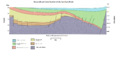
A simplified drawing of the San Luis basin from east to west.
-
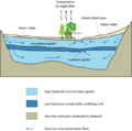
A typical drawing of an underground water source called an aquifer.


See also
 In Spanish: Valle de San Luis para niños
