San Luis Closed Basin facts for kids
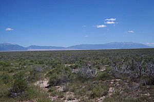
The San Luis Closed Basin is a large, flat area in south-central Colorado. It covers about 2,940 square miles. This area is special because it is an endorheic basin. This means that water flows into it but does not flow out to the ocean. Instead, the water stays within the basin.
The basin is located in Alamosa and Saguache counties. It includes two important creeks: San Luis Creek and Saguache Creek. The basin sits west of the Sangre de Cristo Range, a part of the Rocky Mountains. A raised area called the San Luis Hills separates it from most of the San Luis Valley. The rest of the San Luis Valley drains south into the Rio Grande river.
How Water Works in the Basin
The San Luis Closed Basin is a big part of the eastern side of the Continental Divide in Colorado. The Continental Divide is like a line across the mountains. Water on one side flows to the Pacific Ocean, and water on the other side flows to the Atlantic Ocean.
Historically, all the water that entered this basin would stay there. It would then disappear through a process called evapotranspiration. This means the water would either evaporate into the air or be used by plants. The water would collect in a dry lakebed, also known as a playa, near the Great Sand Dunes.
In the 1970s, a project called the Closed Basin Project began. This project built a canal to move some of the water. This water, which used to stay in the basin, now flows into the Rio Grande river. As part of this project, a new lake was created. This lake is called San Luis Lake. It is used for fun activities like boating and fishing.
Today, the Rio Grande Water Conservation District manages the water in the Closed Basin. They work 24/7 to make sure the water system is maintained.
Plants and Animals
The San Luis Closed Basin is a dry, open area. It has many patches of a plant called greasewood. People in the area often call this plant "chico" or "chico brush."
This basin is also an important place for birds. It is a breeding area for the southwestern willow flycatcher. This small bird is very special because it is an endangered subspecies in the United States. This means there are not many of these birds left, and they need protection to survive.
 | Bayard Rustin |
 | Jeannette Carter |
 | Jeremiah A. Brown |


