San Luis Hills facts for kids
Quick facts for kids San Luis Hills |
|
|---|---|

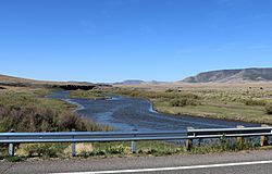
Looking south across the Rio Grande from Highway 142 towards the Piñon Hills
|
|
| Highest point | |
| Peak | (Flat Top) |
| Elevation | 2,806 m (9,206 ft) |
| Dimensions | |
| Area | 428 sq mi (1,110 km2) |
| Geography | |
| Location | San Luis Valley |
| Country | United States |
| State | Colorado |
The San Luis Hills are a group of small mountain ranges in southern Colorado. They are located in Conejos and Costilla counties. These hills are part of the larger San Luis Valley.
The San Luis Hills are made up of several smaller mountain ranges. These include the Fairy Hills, the Brownie Hills, the Piñon Hills, and the South Piñon Hills. The highest point in the San Luis Hills is a peak called Flat Top. It reaches an elevation of 9,206 feet (2,806 metres).
Contents
Where are the San Luis Hills?
Each of the mountain ranges in the San Luis Hills has flat-topped areas and hills. They stretch from the southwest to the northeast. Even though these hills are quite high, they look more like hills than mountains. This is because they rise from the floor of the San Luis Valley. The valley floor is already about 7,500 feet (2,300 metres) above sea level.
All of the San Luis Hills are located within the Sangre de Cristo National Heritage Area. This area helps protect the natural and cultural history of the region.
Exploring the Individual Ranges
The San Luis Hills are divided into four main parts. Each part has its own unique location and features.
The Fairy Hills
The Fairy Hills are found at 37°12′37″N 105°45′14″W / 37.21028°N 105.75389°W. They are located north of Colorado State Highway 142. You can find them west of the Rio Grande river in Conejos County.
The Brownie Hills
The Brownie Hills are at 37°12′39″N 105°42′50″W / 37.21083°N 105.71389°W. These hills are also north of Colorado State Highway 142. However, they are located east of the Rio Grande. They are in Costilla County.
The Piñon Hills
The Piñon Hills are located at 37°07′50″N 105°49′02″W / 37.13056°N 105.81722°W. They are south of Colorado State Highway 142. These hills are west of the Rio Grande and are in Conejos County.
The South Piñon Hills
The South Piñon Hills are at 37°04′17″N 105°48′31″W / 37.07139°N 105.80861°W. As their name suggests, they are south of the main Piñon Hills. They are also in Conejos County. These hills are very close to the border with New Mexico.
How the Hills Were Formed (Geology)
The San Luis Hills are actually the tops of a special kind of underground rock structure. This structure is called an "intra-rift horst". A horst is a block of Earth's crust that has been pushed up between two faults.
The very top layers of these hills are made of Miocene basalt. Basalt is a dark, fine-grained volcanic rock. This basalt is part of something called the Hinsdale Formation. Below the basalt, you'll find older volcanic rocks. These include Oligocene andesite and dacite. Andesite and dacite are also volcanic rocks, but they have slightly different mineral makeups. These older rocks are part of the lower Conejos Formation.
Fun Activities in the Hills (Recreation)
The public lands in the San Luis Hills are not set up with many facilities for visitors. However, you can still find ways to explore them. There are some unofficial hiking trails that people use.
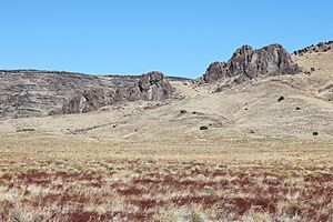
If you enjoy a challenge, mountain climbing and bouldering are possible here. Bouldering is climbing on large rocks or small cliffs without ropes. A popular spot for these activities is around the Manassa Dike. This dike is on the south side of Flat Top.
Protecting the San Luis Hills
Parts of the San Luis Hills are protected to preserve their natural beauty and wildlife.
Wilderness Study Area
The San Luis Hills Wilderness Study Area is a special protected area. It covers about 10,883 acres (4,404 hectares) of land within the Piñon Hills. This area was set aside for study in 1980. It is managed by the Bureau of Land Management. The goal is to see if it should become a permanent wilderness area.
Conservation Efforts
In 2016, a group called the Western Rivers Conservancy helped protect more land. They bought about 17,019 acres (6,887 hectares) in the Brownie Hills. This land is on both sides of the Rio Grande river. Some of it is next to or overlaps with the Rio Grande Natural Area. The plan is for this land to be managed by Costilla County. They will take care of it for wildlife, farming, and as open space for the public to enjoy.


