Conejos County, Colorado facts for kids
Quick facts for kids
Conejos County
|
|
|---|---|

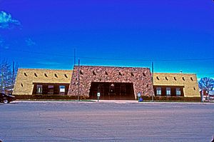
Conejos County Courthouse
|
|

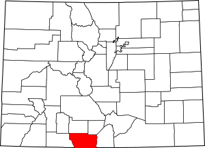
Location within the U.S. state of Colorado
|
|
 Colorado's location within the U.S. |
|
| Country | |
| State | |
| Founded | November 1, 1861 |
| Named for | Conejos River |
| Seat | Conejos |
| Largest town | Manassa |
| Area | |
| • Total | 1,291 sq mi (3,340 km2) |
| • Land | 1,287 sq mi (3,330 km2) |
| • Water | 3.6 sq mi (9 km2) 0.3%% |
| Population
(2020)
|
|
| • Total | 7,461 |
| • Density | 5.8/sq mi (2.2/km2) |
| Time zone | UTC−7 (Mountain) |
| • Summer (DST) | UTC−6 (MDT) |
| Congressional district | 3rd |
Conejos County is a county in the U.S. state of Colorado. A county is like a smaller area within a state, often with its own local government. In 2020, about 7,461 people lived here. The main town, or county seat, is Conejos.
Conejos County is special because in 2020, more than half of its population (50.7%) was Hispanic. This made it Colorado's largest county with a Hispanic majority.
Contents
History
The first European to visit this area was Diego de Vargas in 1694. But he didn't set up any settlements. Later, in 1708, Juan de Uribarri traveled through while looking for Native American slaves who had run away.
Conejos County was one of the first 17 counties created in the Colorado Territory on November 1, 1861. It was first called Guadalupe County. But just a week later, on November 7, its name was changed to Conejos County. The name "Conejos" comes from a Spanish word meaning "rabbit," because there were many rabbits in the area. The county seat was also moved from Guadalupe to Conejos early on.
At first, Conejos County was very large, covering a big part of southwestern Colorado. But over time, parts of it were used to create new counties. In 1874, parts of the west and north became Hinsdale, La Plata, and Rio Grande counties. Then, in 1885, the western half was used to create Archuleta County. After that, Conejos County had the same borders it has today.
Religious History
The community of Conejos is home to the oldest church in Colorado. It's called Our Lady of Guadalupe Parish and was built in 1856. The first people to settle here came from New Mexico. As more people arrived, smaller mission churches were built, and their records were kept at Our Lady of Guadalupe Parish.
Later, when the nearby town of Antonito was built, priests from Spain called Theatines came to the area. They built St. Augustine church in Antonito in 1880. Today, the old church records from Our Lady of Guadalupe Parish are kept at the offices of Saint Augustine church. Conejos is only about a mile northwest of Antonito.
Presbyterians also came to Conejos County in 1880. They started churches in towns like Antonito, Alamosa, and Monte Vista. They also opened schools and had many Hispanic people join their churches.
There is also a large Mormon population in Conejos County. Settlers from The Church of Jesus Christ of Latter-day Saints (LDS Church) began living in towns like La Jara, Manassa, and Sanford. Each of these towns now has an LDS meetinghouse, which is their place of worship. Fox Creek, a small village, also has an LDS meetinghouse, even though most people there are not Mormon.
Geography
Conejos County covers about 1,291 square miles. Most of this area, about 1,287 square miles, is land. Only a small part, about 3.6 square miles, is water.
The county is located in a wide, high mountain valley in south-central Colorado. It's about 825,446 acres in size. Roughly half of the county is on the flat valley floor, which is about 7,700 feet above sea level. The western part of the county has rolling hills and mountains that can reach up to 13,000 feet high.
Conejos County is bordered by the National Forest to the west and the Rio Grande river to the east. It's also right on Colorado's southern border with New Mexico. About 34% of the land in Conejos County is privately owned. The other 66% is public land, like National Forests or land managed by the Bureau of Land Management (BLM).
Climate
In winter, the average temperature is about 21.6 degrees Fahrenheit. The coldest it usually gets each day is around 4 degrees. In summer, the average temperature is about 61.4 degrees, and the warmest it usually gets is around 79.6 degrees.
Most of the yearly rain and snow (71%) falls between April and September. On average, the county gets about 28 inches of snow each winter. The air is usually quite dry, especially in the spring. Conejos County gets a lot of sunshine, about 77% of possible sunshine in summer and 73% in winter.
Adjacent Counties
- Rio Grande County - north
- Alamosa County - northeast
- Costilla County - east
- Taos County, New Mexico - southeast
- Rio Arriba County, New Mexico - south
- Archuleta County - west
National Protected Areas
- Rio Grande National Forest
- San Juan National Forest
- South San Juan Wilderness
Historic Trails and Sites
Scenic Trails and Byways
- Continental Divide National Scenic Trail
Demographics
| Historical population | |||
|---|---|---|---|
| Census | Pop. | %± | |
| 1870 | 2,504 | — | |
| 1880 | 5,605 | 123.8% | |
| 1890 | 7,193 | 28.3% | |
| 1900 | 8,794 | 22.3% | |
| 1910 | 11,285 | 28.3% | |
| 1920 | 8,416 | −25.4% | |
| 1930 | 9,803 | 16.5% | |
| 1940 | 11,648 | 18.8% | |
| 1950 | 10,171 | −12.7% | |
| 1960 | 8,428 | −17.1% | |
| 1970 | 7,846 | −6.9% | |
| 1980 | 7,794 | −0.7% | |
| 1990 | 7,453 | −4.4% | |
| 2000 | 8,400 | 12.7% | |
| 2010 | 8,256 | −1.7% | |
| 2020 | 7,461 | −9.6% | |
| 2023 (est.) | 7,521 | −8.9% | |
| U.S. Decennial Census 1790-1960 1900-1990 1990-2000 2010-2020 |
|||
In 2000, there were 8,400 people living in Conejos County. The population density was about 6 people per square mile. The median age of people in the county was 34 years old.
Communities
Towns
Census-designated places
Other communities
- Bear Creek
- Bountiful
- Cañon
- Carmel
- Elk Creek
- Fox Creek
- Guadalupe
- Horca
- La Florida
- Lasauces
- Las Mesitas
- Lobatos
- Mogote
- Ortiz
- Osier
- Platoro
- Richfield
- Rincones
- San Antonio
- Sheep Creek
Notable People
- Fred Haberlein - A famous muralist (someone who paints large wall paintings).
- Jack Dempsey - A well-known boxer who was born in Manassa, Colorado.
See also
 In Spanish: Condado de Conejos para niños
 | Roy Wilkins |
 | John Lewis |
 | Linda Carol Brown |

