Sanford, Colorado facts for kids
Quick facts for kids
Town of Sanford, Colorado
|
|
|---|---|

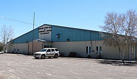
The town hall and community center on Greenleaf Street.
|
|

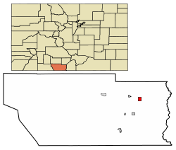
Location of Sanford in Conejos County, Colorado.
|
|
| Country | |
| State | |
| County | Conejos County |
| Incorporated | April 9, 1907 |
| Government | |
| • Type | Statutory Town |
| Area | |
| • Total | 1.46 sq mi (3.78 km2) |
| • Land | 1.46 sq mi (3.78 km2) |
| • Water | 0.00 sq mi (0.00 km2) |
| Elevation | 7,599 ft (2,316 m) |
| Population
(2020)
|
|
| • Total | 879 |
| • Density | 602.1/sq mi (232.5/km2) |
| Time zone | UTC-7 (MST) |
| • Summer (DST) | UTC-6 (MDT) |
| ZIP code |
81151
|
| Area code(s) | 719 |
| FIPS code | 08-67830 |
| GNIS feature ID | 2413256 |
Sanford is a small town in Conejos County, Colorado, United States. It's called a "statutory town" because it follows specific rules set by the state of Colorado for how towns are run. In 2020, about 879 people lived there.
A post office opened in Sanford in 1888. The town got its name from Silas Sanford Smith, an early Mormon pioneer who helped settle the area.
Where is Sanford Located?
Sanford is in the northeastern part of Conejos County. This area is known as the San Luis Valley in southern Colorado.
The town of La Jara is only about 3 miles (4.8 km) west of Sanford. You can get there by taking State Highway 136.
How Big is Sanford?
According to the United States Census Bureau, Sanford covers a total area of about 1.46 square miles (3.78 square kilometers). All of this area is land.
How Many People Live in Sanford?
The number of people living in Sanford has changed over the years. Here's a quick look at the population from different years:
| Historical population | |||
|---|---|---|---|
| Census | Pop. | %± | |
| 1910 | 564 | — | |
| 1920 | 555 | −1.6% | |
| 1930 | 597 | 7.6% | |
| 1940 | 736 | 23.3% | |
| 1950 | 666 | −9.5% | |
| 1960 | 679 | 2.0% | |
| 1970 | 638 | −6.0% | |
| 1980 | 687 | 7.7% | |
| 1990 | 750 | 9.2% | |
| 2000 | 817 | 8.9% | |
| 2010 | 879 | 7.6% | |
| 2020 | 879 | 0.0% | |
See also
In Spanish: Sanford (Colorado) para niños
 | Bessie Coleman |
 | Spann Watson |
 | Jill E. Brown |
 | Sherman W. White |

