Taos County, New Mexico facts for kids
Quick facts for kids
Taos County
|
||
|---|---|---|

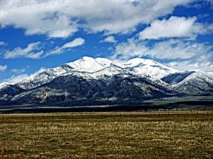
Taos Mountain from El Prado
|
||
|
||

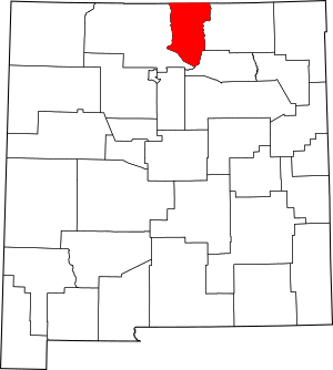
Location within the U.S. state of New Mexico
|
||
 New Mexico's location within the U.S. |
||
| Country | ||
| State | ||
| Founded | January 9, 1852 | |
| Seat | Taos | |
| Largest town | Taos | |
| Area | ||
| • Total | 2,204 sq mi (5,710 km2) | |
| • Land | 2,203 sq mi (5,710 km2) | |
| • Water | 1.3 sq mi (3 km2) 0.06%% | |
| Population
(2020)
|
||
| • Total | 34,489 | |
| • Density | 15.648/sq mi (6.0419/km2) | |
| Time zone | UTC−7 (Mountain) | |
| • Summer (DST) | UTC−6 (MDT) | |
| Congressional district | 3rd | |
Taos County is a special area, like a district, in the U.S. state of New Mexico. In 2020, about 34,489 people lived here. The main town and government center is called Taos.
Taos County was created in 1852. It was one of the first nine counties in the New Mexico Territory. The area around Taos town is also known as the Taos Micropolitan Statistical Area. This means it's a small city area with close ties to nearby communities.
Contents
Geography of Taos County
Taos County covers a total area of about 2,204 square miles (5,708 square kilometers). Most of this area, about 2,203 square miles (5,706 square kilometers), is land. Only a small part, about 1.3 square miles (3.4 square kilometers), is water.
Highest Points and Mountains
The highest point in Taos County is the top of Wheeler Peak. It stands at 13,161 feet (4,011 meters) tall. This peak is also the highest natural point in all of New Mexico.
Taos County has many tall mountains. It has the highest average elevation of any U.S. county outside of Colorado. Its average height is 8,510 feet (2,594 meters). The county is home to 17 of New Mexico's 25 highest peaks.
Neighboring Counties
Taos County shares borders with several other counties:
- Rio Arriba County to the west
- Mora County to the southeast
- Colfax County to the east
- Costilla County, Colorado to the north
- Conejos County, Colorado to the northwest
Protected Natural Areas
A part of the Carson National Forest is located within Taos County. This is a large area of protected forest land. The Rio Grande del Norte National Monument is also found here. It protects important natural and cultural sites along the Rio Grande River.
People and Population in Taos County
The number of people living in Taos County has changed over many years.
| Historical population | |||
|---|---|---|---|
| Census | Pop. | %± | |
| 1850 | 9,507 | — | |
| 1860 | 14,103 | 48.3% | |
| 1870 | 12,079 | −14.4% | |
| 1880 | 11,029 | −8.7% | |
| 1890 | 9,868 | −10.5% | |
| 1900 | 10,889 | 10.3% | |
| 1910 | 12,008 | 10.3% | |
| 1920 | 12,773 | 6.4% | |
| 1930 | 14,394 | 12.7% | |
| 1940 | 18,528 | 28.7% | |
| 1950 | 17,146 | −7.5% | |
| 1960 | 15,934 | −7.1% | |
| 1970 | 17,516 | 9.9% | |
| 1980 | 19,456 | 11.1% | |
| 1990 | 23,118 | 18.8% | |
| 2000 | 29,979 | 29.7% | |
| 2010 | 32,937 | 9.9% | |
| 2020 | 34,489 | 4.7% | |
| 2021 (est.) | 34,623 | 5.1% | |
| U.S. Decennial Census 1790-1960 1900-1990 1990-2000 2010 |
|||
Population Details from 2010
In 2010, there were 32,937 people living in Taos County. These people lived in 14,806 households. About 8,437 of these were families. The county had about 15 people per square mile.
Most people in the county identified as white (68.7%). About 6.2% were American Indian. People of Hispanic or Latino origin made up 55.8% of the population. The average age of people in Taos County was 45.2 years.
The average income for a household was $35,441. For families, it was $43,236. About 17% of the population lived below the poverty line. This included 28.3% of those under 18 years old.
Towns and Villages in Taos County
Taos County has several towns and villages.
Main Towns
Villages
Other Communities
Many other smaller communities are found in Taos County. Some are called Census-Designated Places (CDPs). This means they are areas identified for census data.
- Arroyo Hondo
- Arroyo Seco
- Chamisal
- Costilla
- Ojo Caliente (part)
- Peñasco
- Picuris Pueblo
- Ranchos de Taos
- Rio Lucio
- San Cristobal
- Talpa
- Taos Pueblo
- Vadito
- Amalia
- Cañoncito
- Carson
- Cerro
- El Prado
- El Rito
- Las Trampas
- Llano
- Llano Quemado
- No Agua
- Pilar
- Tres Piedras
- Valdez
Schools in Taos County
Children in Taos County attend schools in several different school districts:
- Mesa Vista Consolidated Schools
- Peñasco Independent Schools
- Questa Independent Schools
- Taos Municipal Schools
See also
 In Spanish: Condado de Taos para niños
 | Aurelia Browder |
 | Nannie Helen Burroughs |
 | Michelle Alexander |


