
Amalia, New Mexico facts for kids
Quick facts for kids
Amalia, New Mexico
|
|
|---|---|

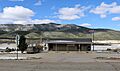
The post office in Amalia
|
|

Amalia, New Mexico
Location in New Mexico

Amalia, New Mexico
Location in the United States
|
|
| Country | United States |
| States | New Mexico |
| County | Taos |
| Elevation | 8,147 ft (2,483 m) |
| Time zone | UTC−7 (Mountain (MST)) |
| • Summer (DST) | UTC−6 (MDT) |
| ZIP code |
87512
|
| Area code(s) | 575 |
| GNIS feature ID | 902162 |
Amalia is an unincorporated community in Taos County, New Mexico, United States. It is a small place that is not officially part of a city or town.
About Amalia

Amalia is located very close to the border of Colorado. You can find it along New Mexico State Road 196.
This community has its own post office. The ZIP code for Amalia is 87512. In the year 2000, about 230 people lived in the area covered by this ZIP code.
History of Amalia
Amalia was once known by a different name: Pina. This name might have come from the Spanish word for 'pine tree'.
A post office was first opened in Amalia in 1900. Later, in 1919, the community's name was changed to Amalia. The reason for this name change is not known. Amalia is a common given name.
Images for kids
-
The post office in Amalia

All content from Kiddle encyclopedia articles (including the article images and facts) can be freely used under Attribution-ShareAlike license, unless stated otherwise. Cite this article:
Amalia, New Mexico Facts for Kids. Kiddle Encyclopedia.