Cerro, New Mexico facts for kids
Quick facts for kids
The Village of Cerro
|
|
|---|---|

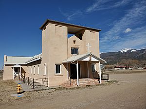
Nuestra Senora de Guadalupe Catholic Church in Cerro, March 2021
|
|
| Country | United States |
| State | New Mexico |
| County | Taos |
| Elevation | 7,602 ft (2,317 m) |
| Population
(2000)
|
|
| • Total | 428 |
| Time zone | UTC-7 (Mountain (MST)) |
| • Summer (DST) | UTC-6 (MDT) |
| ZIP code |
87519
|
| Area code(s) | 575 |
| GNIS feature ID | 904926 |
| Website | http://www.laplaza.org/government/cerro/ |
Cerro is a small, quiet community located in Taos County, New Mexico, in the United States. It's what's called an "unincorporated community," which means it's a place with a shared identity but doesn't have its own local government like a city or town. Cerro is found along New Mexico State Road 378. Settlers from nearby Taos and Questa founded Cerro in 1854. They named it after a special place called Cerro Guadalupe.
Understanding Cerro's Weather
Cerro has a specific type of weather pattern. Scientists use the Köppen Climate Classification system to describe climates around the world. Cerro's climate is known as "warm-summer humid continental," or "Dfb" on climate maps. This means it has warm summers and cold, snowy winters.
Temperature Records
The highest temperature ever recorded in Cerro was a very hot 100 °F (37.8 °C) degrees on June 19, 1924. On the other hand, the coldest temperature ever recorded was a freezing −34 °F (−36.7 °C) degrees. This happened twice: once on January 29, 1919, and again on January 6, 1971. These extreme temperatures show how much the weather can change in Cerro throughout the year.
| Climate data for Cerro, New Mexico, 1991–2020 normals, extremes 1910–2022 | |||||||||||||
|---|---|---|---|---|---|---|---|---|---|---|---|---|---|
| Month | Jan | Feb | Mar | Apr | May | Jun | Jul | Aug | Sep | Oct | Nov | Dec | Year |
| Record high °F (°C) | 63 (17) |
65 (18) |
77 (25) |
82 (28) |
95 (35) |
100 (38) |
97 (36) |
98 (37) |
96 (36) |
88 (31) |
77 (25) |
68 (20) |
100 (38) |
| Mean maximum °F (°C) | 50.3 (10.2) |
54.2 (12.3) |
67.3 (19.6) |
73.0 (22.8) |
80.4 (26.9) |
88.6 (31.4) |
90.4 (32.4) |
87.8 (31.0) |
84.2 (29.0) |
76.3 (24.6) |
64.3 (17.9) |
53.2 (11.8) |
91.5 (33.1) |
| Mean daily maximum °F (°C) | 36.8 (2.7) |
42.1 (5.6) |
53.1 (11.7) |
61.7 (16.5) |
69.8 (21.0) |
80.1 (26.7) |
83.0 (28.3) |
80.5 (26.9) |
75.1 (23.9) |
64.6 (18.1) |
50.9 (10.5) |
37.9 (3.3) |
61.3 (16.3) |
| Daily mean °F (°C) | 22.3 (−5.4) |
28.1 (−2.2) |
37.1 (2.8) |
44.4 (6.9) |
52.4 (11.3) |
62.1 (16.7) |
66.1 (18.9) |
64.3 (17.9) |
58.3 (14.6) |
47.2 (8.4) |
34.9 (1.6) |
23.5 (−4.7) |
45.1 (7.2) |
| Mean daily minimum °F (°C) | 7.9 (−13.4) |
14.0 (−10.0) |
21.0 (−6.1) |
27.0 (−2.8) |
35.1 (1.7) |
44.0 (6.7) |
49.2 (9.6) |
48.2 (9.0) |
41.4 (5.2) |
29.7 (−1.3) |
18.9 (−7.3) |
9.0 (−12.8) |
28.8 (−1.8) |
| Mean minimum °F (°C) | −10.7 (−23.7) |
−5.6 (−20.9) |
3.2 (−16.0) |
13.4 (−10.3) |
22.5 (−5.3) |
32.2 (0.1) |
40.7 (4.8) |
40.6 (4.8) |
28.4 (−2.0) |
13.8 (−10.1) |
0.6 (−17.4) |
−9.1 (−22.8) |
−14.5 (−25.8) |
| Record low °F (°C) | −34 (−37) |
−33 (−36) |
−16 (−27) |
−6 (−21) |
11 (−12) |
22 (−6) |
25 (−4) |
30 (−1) |
18 (−8) |
−3 (−19) |
−20 (−29) |
−30 (−34) |
−34 (−37) |
| Average precipitation inches (mm) | 0.67 (17) |
0.66 (17) |
0.91 (23) |
0.97 (25) |
1.12 (28) |
0.67 (17) |
1.68 (43) |
2.25 (57) |
1.68 (43) |
1.04 (26) |
0.81 (21) |
0.91 (23) |
13.37 (340) |
| Average snowfall inches (cm) | 12.7 (32) |
11.7 (30) |
8.0 (20) |
4.3 (11) |
0.7 (1.8) |
0.0 (0.0) |
0.0 (0.0) |
0.0 (0.0) |
0.0 (0.0) |
3.4 (8.6) |
6.8 (17) |
13.9 (35) |
61.5 (155.4) |
| Average precipitation days (≥ 0.01 in) | 4.4 | 4.4 | 4.4 | 4.7 | 4.9 | 3.5 | 8.5 | 9.6 | 6.1 | 4.4 | 4.2 | 4.5 | 63.6 |
| Average snowy days (≥ 0.1 in) | 3.9 | 3.5 | 2.4 | 1.6 | 0.2 | 0.0 | 0.0 | 0.0 | 0.0 | 1.0 | 2.4 | 3.9 | 18.9 |
| Source 1: NOAA | |||||||||||||
| Source 2: National Weather Service | |||||||||||||
 | Lonnie Johnson |
 | Granville Woods |
 | Lewis Howard Latimer |
 | James West |


