
Las Trampas, New Mexico facts for kids
Quick facts for kids
Las Trampas, New Mexico
|
|||||||||||||||||||||||||||||||
|---|---|---|---|---|---|---|---|---|---|---|---|---|---|---|---|---|---|---|---|---|---|---|---|---|---|---|---|---|---|---|---|

Las Trampas, New Mexico
Location in New Mexico

Las Trampas, New Mexico
Location in the United States
|
|||||||||||||||||||||||||||||||
| Country | United States | ||||||||||||||||||||||||||||||
| State | New Mexico | ||||||||||||||||||||||||||||||
| County | Taos County | ||||||||||||||||||||||||||||||
| Elevation | 7,428 ft (2,264 m) | ||||||||||||||||||||||||||||||
| Population
(2023)
|
|||||||||||||||||||||||||||||||
| • Total | 43 | ||||||||||||||||||||||||||||||
| Time zone | UTC-7 (Mountain (MST)) | ||||||||||||||||||||||||||||||
| • Summer (DST) | UTC-6 (MDT) | ||||||||||||||||||||||||||||||
| GNIS feature ID | 911790 | ||||||||||||||||||||||||||||||
|
|||||||||||||||||||||||||||||||

Las Trampas (which means "traps" in Spanish) is a small, historic village in Taos County, New Mexico. It was founded in 1751 and still has its original Spanish colonial layout. The village is home to the beautiful 18th-century San José de Gracia Church. This church is one of the best examples of old Spanish colonial church design in the United States. Because of its history and unique buildings, the village center was named a National Historic Landmark District in 1967. In 2023, only 43 people lived there.
Contents
Where is Las Trampas?
Las Trampas is found along the scenic High Road to Taos (New Mexico State Road 76). This road winds through the Sangre de Cristo Mountains. The village is located about halfway between the cities of Santa Fe to the south and Taos to the north. It sits at an elevation of about 7,440 feet (2,268 meters) above sea level.
The village has its own post office with the ZIP code 87576. The US Postal Service actually prefers to call the area "Trampas."
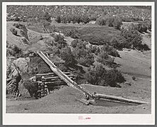
Trampas is built on a flat, narrow plain next to the Rio de las Trampas. This river is a small branch of the Embudo River. The plain stretches about 1 mile (1.6 km) along the river and is about 0.25 miles (0.4 km) wide. Forests and mountains of the Carson National Forest surround this plain. Two special irrigation ditches, called acequias, run alongside the river. They bring water to farmers for their crops. A cool feature of these acequias is the "canoa." This is a hollow log, carved by hand, that acts like a bridge to carry water over ditches or low spots.
A Look at Las Trampas' History
In the mid-1700s, the Spanish colony of New Mexico faced many challenges. There were about 7,000 to 8,000 Spanish settlers and fewer than 10,000 Puebloans (Native Americans). They lived spread out along the Rio Grande valley. To help protect the colony, the governor of New Mexico decided to create new settlements on the edges of the territory.
The very first settlement in Trampas was a Franciscan mission for the Jicarilla Apache people. It was started in 1733. At its busiest, 132 Jicarilla lived there, but the mission closed in the 1740s.
In 1751, the governor gave a land grant to new settlers. This grant was about 28,132 acres (11,385 hectares). Twelve families from Santa Fe founded the village of Santo Tomas Apostol del Rio de Las Trampas that same year. It was one of the first "genízaro" settlements. Genízaros were Native Americans who had become part of Spanish colonial society. They were very important for defending the frontier of New Mexico. Moving to places like Trampas helped them get their own land. Some early settlers were also Tlaxcalans, Mexican Native Americans who often helped the Spanish.
The governor ordered that the settlement be built like a fort. It had a central plaza (a town square) that could only be entered through one gate. When there was danger, settlers could bring their livestock into the plaza for safety. The houses were built connected to each other, forming a protective circle around the plaza. A low adobe wall also surrounded the village.
Even with the risk of attacks, the village grew. By 1776, there were 63 families and 278 people living there. People at that time described them as "ragged" but "festive" and "very merry." They spoke a mix of "local Spanish" and the Tanoan language of the Taos Pueblo. Many also knew some words from the Comanche, Ute, and Apache languages. The village remained quite isolated until the 1920s.
Las Trampas is especially famous for its San José de Gracia Church. This church was built between 1760 and 1776. It is seen as a perfect example of the adobe colonial Spanish missions in New Mexico.
Las Trampas Historic District
The Las Trampas Historic District was officially recognized in 1967. It includes the main part of the village. The buildings mostly follow the original plan from 1751. Most of the buildings you see today were built in the 1800s, with some changes made later in that century. The San José de Gracia Church is the only building from the 1700s that is still standing. It is a National Historic Landmark because of its amazing architecture. The old defensive wall that once surrounded the village is no longer there.
Gallery
-
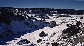
A view of Trampas and the Sangre de Cristo Mountains in Spring 1943. The structure crossing a ravine looks like a canoa, which is a hand-made flume for irrigation water.
-
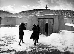
People leaving after services at San José de Gracia Church in 1943.
-
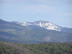
A view of Santa Fe Baldy, a mountain in the Sangre de Cristo Mountains, seen from near Las Trampas.
-
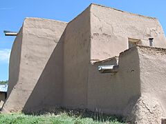
The Catholic Church at Las Trampas (north view).
-
Irrigation water crosses a ditch using a hollowed-out log called a canoa. Photo from the 1930s.


.JPG)

See also
 In Spanish: Las Trampas para niños
