
Santa Fe Baldy facts for kids
Quick facts for kids Santa Fe Baldy |
|
|---|---|

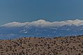
From the White Rock overlook.
|
|
| Highest point | |
| Elevation | 12,632 ft (3,850 m) NAVD 88 |
| Prominence | 1,982 ft (604 m) |
| Parent peak | Truchas Peak |
| Geography | |
| Location | Santa Fe County, New Mexico, U.S. |
| Parent range | Sangre de Cristo Mountains |
| Topo map | USGS Aspen Basin |
| Climbing | |
| Easiest route | Off-trail hike |
Santa Fe Baldy is a tall mountain peak in the Sangre de Cristo Mountains of New Mexico, United States. It is about 15 miles (24 km) northeast of the city of Santa Fe. This mountain is one of the highest points in New Mexico south of its location.
You can easily see Santa Fe Baldy from places like Los Alamos and towns along the Rio Grande river. However, it looks smaller from Santa Fe because of how its main ridge faces the city. The tree line (where trees stop growing due to high elevation) in these mountains is very high, often over 12,000 feet. This means only the top 600 to 800 feet of Santa Fe Baldy are naturally without trees. But, some big forest fires have also cleared areas at lower elevations. In the fall, the many aspen trees on the mountain turn bright orange and yellow, making it a popular spot for photos.
Contents
Exploring Santa Fe Baldy's Location
Santa Fe Baldy is located inside the Pecos Wilderness, which is part of the Santa Fe National Forest. It sits on a water divide, meaning it separates the areas where water flows into the Rio Grande and the Pecos River.
Rivers and Lakes Around the Mountain
The western side of the mountain has rivers like the Rio Capulin and the Rio Nambe. Both of these rivers flow into the Rio Grande. On the eastern side, there are two small bowl-shaped valleys called cirques. One of these cirques holds Lake Katherine. This lake is one of the highest lakes in New Mexico, sitting at an elevation of 11,745 feet.
Many people used to think that J. Robert Oppenheimer, a famous scientist, named Lake Katherine after his wife, Katherine "Kitty" Oppenheimer. But this is not true! The lake was actually named after Katherine Chaves Page Kavanaugh. She owned a guest ranch nearby on the Pecos River. Oppenheimer did visit her ranch often, which might be why people got confused about the lake's name.
Hiking to the Summit
You can reach the top of Santa Fe Baldy by following Trail 251, also known as the Skyline Trail. This trail leads to a flat area (a saddle) about 1,000 feet below the very top. From there, a steep, unofficial path goes up the rest of the way along the mountain ridge.
Safety Tips for Hikers
When the weather is good, climbing to the summit is a simple hike. However, the Sangre de Cristo Mountains are known for having a lot of lightning. During the summer, it's smart for hikers to be off Santa Fe Baldy and other high peaks by noon. This helps them avoid afternoon thunderstorms, which can be dangerous.
Nearby Peaks
Other tall mountains close to Santa Fe Baldy include Lake Peak, which is 12,409 feet high, and Tesuque Peak, at 12,043 feet. Both of these peaks are about 3 miles south of Santa Fe Baldy. The Santa Fe Ski Basin is located on the western slopes of Tesuque Peak.
Images for kids
-
With fresh snow, January 2010
-
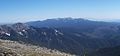
From Truchas Peak, with Pecos Baldy in the foreground
-
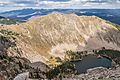
Looking down on Lake Katherine from near the peak of Santa Fe Baldy
-
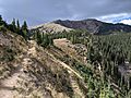
Looking north-northeast from the switch-backed section of the trail to Lake Katherine summit


