Truchas Peak facts for kids
Quick facts for kids Truchas Peak |
|
|---|---|

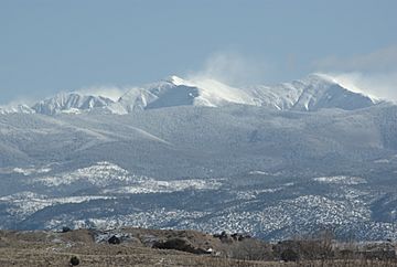
Truchas Peaks from Española in winter
|
|
| Highest point | |
| Elevation | 13,108 ft (3,995 m) NAVD 88 |
| Prominence | 4,001 ft (1,220 m) |
| Geography | |
| Location | Rio Arriba / Mora counties, New Mexico, U.S. |
| Parent range | Sangre de Cristo Mountains |
| Topo map | USGS Truchas Peak |
| Climbing | |
| Easiest route | Scramble, class 2 |
Truchas Peak is a super tall mountain in New Mexico, USA. It's the second highest peak in the whole state, right after Wheeler Peak. This amazing mountain is part of the Sangre de Cristo Mountains. It's also special because its name, "Truchas," means "trout" in Spanish!
Truchas Peak is the highest point in both Rio Arriba and Mora counties. It's also the most southerly place in the continental United States that rises above 13,000 feet (about 3,962 meters).
Contents
Exploring Truchas Peak: New Mexico's High Mountain
Where is Truchas Peak?
Truchas Peak is located about 26 miles (42 kilometers) northeast of Santa Fe. It sits inside the Pecos Wilderness, which is a special protected area. This wilderness is part of the Santa Fe National Forest. The northern edge of the mountain also touches the Carson National Forest.
The Peaks of Truchas
Truchas Peak isn't just one single point. It's actually a small group of mountains that stretch from north to south. This group has four main high points, called summits:
- North Truchas Peak
- Middle Truchas Peak
- "Medio Truchas Peak" (this is an unofficial name)
- South Truchas Peak (this is the very highest one!)
Out of these, North Truchas Peak is about 13,029 feet (3,971 meters) tall. It stands out enough from the other peaks to be considered its own independent mountain.
Where Does the Water Go?
The Truchas Peaks sit on a very important line called a divide. This divide separates where water flows. On one side, water from the peaks flows into the Rio Grande. On the other side, it flows into the Pecos River.
Water from the western side of the mountain flows into rivers like the Rio Medio, the Rio Quemado, and the Rio de las Trampas. On the northeast side, water goes into the Rio Santa Barbara. And on the southeast, small streams quickly join the upper parts of the Pecos River.
The Truchas mountain group is also connected to many other tall peaks nearby. Some of these connections are through a big ridge called the Santa Barbara Divide. This ridge separates the Pecos River area to the south from the Santa Barbara River area to the north.
Visiting Truchas Peak
The Truchas mountain group feels like a true wilderness. It's quite challenging to reach the very top of these peaks in just one day. Many trails lead up the sides of the mountains. One of the most famous is the Skyline Trail (Trail number 251). This trail goes along the eastern slopes at an elevation of about 12,000 feet (3,660 meters).
The Skyline Trail also leads to the Truchas Lakes. These are a group of small lakes found in a bowl-shaped valley called a cirque. You can find them below the south side of North Truchas Peak. It's a beautiful and wild place to explore!
 | Janet Taylor Pickett |
 | Synthia Saint James |
 | Howardena Pindell |
 | Faith Ringgold |

