
Questa, New Mexico facts for kids
Quick facts for kids
The Village of Questa
|
|
|---|---|
|
Village
|
|

Questa, NM and scenic views
|
|
| Motto(s):
Gateway to the Rio Grande del Norte National Monument
|
|

Location of Questa, New Mexico
|
|

Questa, New Mexico
Location in the United States
|
|
| Country | United States |
| State | New Mexico |
| County | Taos |
| Government | |
| • Type | Municipal |
| Area | |
| • Total | 7.59 sq mi (19.66 km2) |
| • Land | 7.08 sq mi (18.33 km2) |
| • Water | 0.51 sq mi (1.33 km2) |
| Elevation | 7,615 ft (2,321 m) |
| Population
(2020)
|
|
| • Total | 1,742 |
| • Density | 246.15/sq mi (95.04/km2) |
| Time zone | UTC-7 (Mountain (MST)) |
| • Summer (DST) | UTC-6 (MDT) |
| ZIP code |
87556
|
| Area code(s) | 575 |
| FIPS code | 35-60870 |
| GNIS feature ID | 2413580 |
| Website | http://questa-nm.com/ |
Questa is a small village located in Taos County, New Mexico, United States. In 2020, about 1,742 people lived there.
Questa is a great place for outdoor adventures. You can find trails leading into the amazing Rio Grande Gorge. It's also known for trout fishing and beautiful mountain lakes. These lakes have trails that go up into the Sangre de Cristo Mountains.
The village is part of the Enchanted Circle Scenic Byway. It is close to where the Rio Grande and the Red River meet. Questa is called the "Gateway to the Rio Grande del Norte Monument". Visitors can drive to a viewpoint to see the Red River join the Rio Grande deep inside the gorge. The Carson National Forest is right next to Questa on its east side. Two wilderness areas, Columbine Hondo and Latir Peak, are also nearby in the Carson National Forest.
Questa has a large Hispanic population. In the past, the village's economy mostly relied on farming. It also depended on a molybdenum mine owned by Chevron, which is now closed. Many people who live in Questa travel to nearby towns like Taos, Red River, and Angel Fire for jobs in hotels and tourism.
Contents
Exploring Questa's Location

Questa is a village that covers about 5.1 square miles (13.2 square kilometers) of land. It serves as a central point for smaller communities nearby. These include Lama, Cerro, Sunshine Valley, Latir, Costilla, and Amalia.
The village is surrounded by nature. To the west, you'll find the Rio Grande del Norte National Monument. To the east, there's the Carson National Forest.
Questa sits at the base of the Taos Mountains. These mountains are part of the larger Sangre de Cristo Mountains. Northeast of Questa, you can see the Latir Peak mountain group. The highest point there is Venado Peak, which is 12,734 feet (3,881 meters) tall. Closer to Questa is Pinabete Peak. To the southeast is Flag Mountain, which is connected to mountains like Wheeler Peak, the highest mountain in New Mexico. To the north and west, the Rio Grande Gorge cuts through a volcanic area. This area has several volcanic peaks and is part of the Rio Grande del Norte National Monument.
A Look at Questa's Past


Questa was first called San Antonio del Rio Colorado. In 1883, a U.S. postmaster changed its name to Questa. The postmaster made a spelling mistake. It should have been "Cuesta," which means "ridge" or "slope" in Spanish. Even with the mistake, the village kept the name.
The first signs of people living near Questa date back to about 3000 BCE. These were Native American groups from the Oshara tradition. They might have been the ancestors of today's Pueblo peoples. Later, a trade route called the "Kiowa Trail" or "Taos Mountain Trail" went through Questa. This trail connected the farming Pueblo people in New Mexico with the Plains Indians in Colorado, who hunted bison.
The first Spanish explorers came to the area in 1540. They were part of the Coronado expedition and visited Taos Pueblo, which is about 20 miles (32 km) south of Questa.
Early Spanish and Mexican Settlements
The Spanish settlement of Don Fernando de Taos was founded around 1615. It was next to Taos Pueblo. Spanish explorers, hunters, and miners likely visited the Questa area after that. The first official visit by the Spanish was in July 1694. Governor Diego de Vargas led an expedition from Santa Fe. He was looking for food for the Spanish colony.
Vargas and his 100 men passed by the future site of Questa. He noted that the area was home to the "Apaches de Acho." Utes, who were not friendly with the Spanish, also lived nearby. Many Bison were in the region. The Ute and Apache – and later the Comanche – were hostile. This stopped the Spanish from expanding north from Taos to Questa.
The area of Questa was first called Rio Colorado. Around 1815, the Spanish set up a short-lived military post there. They were worried about French and American fur traders. In the same year, 50 families were allowed to start a settlement at Rio Colorado. In 1817, the military at Rio Colorado stopped and arrested French/American traders Auguste Pierre Chouteau and Jules de Mun. By 1822, the settlement was empty because people were "in fear of the Indians."
Mexico became independent from Spain in 1821. This led to a more open attitude toward Americans. By 1829, Rio Colorado was settled again. Most settlers were Hispanic, but some French/Americans also lived there.
The Mexican government encouraged people to settle new areas. They gave land grants to Mexican citizens. Large land grants were given in 1836 and 1841. The town of San Antonio del Rio Colorado was officially started in 1842.
Questa Becomes Part of the United States
New Mexico became part of the United States after the Mexican-American War (1846-1848). Native American raids in the area continued until the 1860s. Questa was located on old trade, raiding, and hunting paths. This often led to conflicts between different groups. Also, the village blocked access to important clay and pigment quarries for the Taos tribe. Because of these conflicts, the village was often abandoned. Soldiers from Spain, Mexico, and later America were sent to protect the settlement. They often found their job very frustrating.
Two tall mountains near Questa are called Flag Mountain and Sentinel Peak. Their names come from a time when watchmen stood on these high points. They would warn the village if enemy groups were coming.
From early on, the village had a mix of people. Surnames like Lafore, Ledoux, and LaCome show that French or French-Canadian trappers settled there. They came looking for otters and beavers. Records show that Auguste Lacome lived in the area as a trader with Native Americans. The common surname Rael might also come from Jewish immigrants who arrived after being forced out of Spain. The village was known for having many arguments. Government leaders often had to step in to settle property disputes.
Arts and Culture in Questa

The Historic San Antonio del Rio Colorado Church is in Questa's old town square. It has been there since the mid-1800s. After one of its walls collapsed, the community worked to restore it. The church is made with adobe and wood.
Questa also has Ocho, an art gallery and space for events.
Fun Events in Questa
Questa hosts a series of events in the summer. These events celebrate art, young people, and the environment. Some special events include Mud Bogg, the Questa Fiesta, and Alumbra de Questa.
Parks and Outdoor Fun
Questa has two local parks: the Municipal Park and the Moly Park. Moly Park has public sports fields.

Around Questa, you'll find the Rio Grande del Norte National Monument and the Carson National Forest. Just outside Questa's village limits is Eagle Rock Lake. The Red River is being restored to make it a better home for trout. The part of the river next to Eagle Rock Lake is already finished.
Cabresto Lake offers hiking trails that lead to mountain lakes in the Latir Peaks Wilderness. In the Rio Grande del Norte National Monument, there are two popular spots. The La Junta Overlook lets you see where the Rio Grande and the Red River meet, over 800 feet (244 meters) below. The Big Arsenic Trail has ancient rock carvings called petroglyphs and a natural spring.
Questa's Economy
.jpg)
The Chevron Questa molybdenum mine was about 9 miles (14 km) from Questa. It used to be the biggest private employer in Taos County. The mine started in 1916. Chevron bought it in 2005. It was an underground mine from 1982.
In 2009, the mine cut 54 percent of its staff because of economic problems. This mostly affected Questa residents. On June 2, 2014, Chevron Mining announced the mine would close permanently. This was due to low molybdenum prices and high operating costs. About 300 people worked at the mine when it closed. Now, about 150 people work there on projects to clean up and restore the area.
Farming is still important in Questa. People grow alfalfa, hay, and winter wheat. There is also new interest in growing traditional and valuable crops. Farming in Questa relies heavily on irrigation. Water comes from the Red River and Cabresto Creek. The system of ditches, called acequias, is very important to the community. Burning the ditches after the spring equinox is a big community event. Two main "ditch associations" manage water from the Cabresto Lake dam: the Acequia Madre and the Llano ditch.
In the past, sheep were raised around Questa, but now cattle are more common. Cattle graze north and west of town in winter and spring. In early June, they are moved across the "Sheep Crossing" ford by riders on horseback.
The traditional economy of Questa is changing. Farming, livestock, handmade items like wooden religious carvings (called santos), wood gathering, and honey are not always enough for people's financial needs. Some locals think this is because famous and wealthy people are moving to the Taos area, which drives up land and home prices. Because of this, more and more people from Questa travel to work in Red River, Taos, and Angel Fire.
Questa has also become a place for tourists. With the Historic San Antonio del Rio Colorado Church, Rio Grande del Norte National Monument, Eagle Rock Lake, and the Carson National Forest, many opportunities for tourism have grown.
Education in Questa
The Questa Independent School System is the local school district. It runs two schools: Alta Vista Elementary & Intermediate School, and Questa Junior & Senior High School.
Roots and Wings Community school is near Questa, in the Lama area. It is an Expeditionary Learning School.
Transportation and Services
Major Roads

Questa's village center has two main New Mexico State Highways: 522 and 38. State Highway 522 goes south to Taos and north to the Colorado border. State Highway 38 connects Questa to Red River and Eagle Nest. It is part of the Enchanted Circle.
Getting Around
Questa has a free bus service called the North Central RTD's Blue Bus. It provides rides to Red River and Taos during commuting hours. For air travel, the Questa Municipal Airport Nr 2 is available. The Village of Questa owns this airport.
Utilities and Healthcare
The Water/Sewer Department of the Village of Questa manages water and sewer services for the area. Kit Carson Electric Cooperative, Inc. provides electricity. They are also working on a fiber optic project in Taos County.
Presbyterian Medical Services' Questa Health Clinic offers medical, dental, and mental health care for Questa and nearby areas. The closest hospital to Questa is Holy Cross Hospital in Taos, about 30 miles (48 km) away.
Images for kids
-
Questa in 1943
-
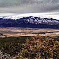
A view of Questa from the Rio Grande del Norte National Monument
-
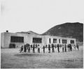
Questa School in 1941
-
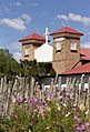
Historic San Antonio del Rio Colorado Church of Questa
-
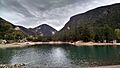
Eagle Rock Lake Questa, NM
-
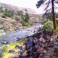
The Rio Grande in the Rio Grande del Norte National Monument
-
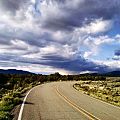
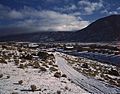
Road in the Rio Grande del Norte National Monument
See also
 In Spanish: Questa para niños
