Angel Fire, New Mexico facts for kids
Quick facts for kids
Angel Fire, New Mexico
|
||
|---|---|---|
|
Village
|
||

Village of Angel Fire
|
||
|
||
| Motto(s):
"Reach New Heights"
|
||

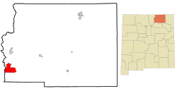
Location of Angel Fire, New Mexico
|
||
| Country | United States | |
| State | New Mexico | |
| County | Colfax | |
| Established | 1982 | |
| Incorporated | 1986 | |
| Area | ||
| • Total | 28.84 sq mi (74.71 km2) | |
| • Land | 28.80 sq mi (74.61 km2) | |
| • Water | 0.04 sq mi (0.10 km2) | |
| Elevation | 8,882 ft (2,707 m) | |
| Population
(2020)
|
||
| • Total | 1,192 | |
| • Density | 41.38/sq mi (15.98/km2) | |
| Time zone | UTC-7 (Mountain (MST)) | |
| • Summer (DST) | UTC-6 (MDT) | |
| ZIP code |
87710
|
|
| Area code(s) | 575 | |
| FIPS code | 35-03400 | |
| GNIS feature ID | 2413529 | |
Angel Fire is a small village located in Colfax County, New Mexico, United States. In 2020, about 1,192 people lived there.
Angel Fire is well-known for the Angel Fire Resort. This is a very popular place for skiing and snowboarding, with over 500 acres (2.0 km²) of slopes. The weather in Angel Fire is usually cold in winter and mild in summer.
North of the village, you can find the Vietnam Veterans Memorial State Park. Angel Fire is also part of the beautiful Enchanted Circle Scenic Byway, a special road for sightseeing.
Contents
Where is Angel Fire located?

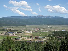
Angel Fire is in the southwestern part of Colfax County. The main part of the village is in a valley. Houses are built on the mountain slopes nearby.
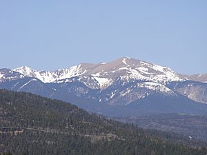
The Angel Fire Resort is inside the village limits. Its base is at 8,600 feet (2,621 m) high. The top of the ski area is at 10,677 feet (3,254 m). A mountain called Agua Fria Peak, which is 11,078 feet (3,377 m) high, is to the southeast.
The village stretches north to U.S. Route 64. This road is about 10 miles (16 km) south of Eagle Nest. If you go west on US 64, you'll cross Palo Flechado Pass in the Sangre de Cristo Mountains. It's about 21 miles (34 km) to Taos from there.
New Mexico State Road 434 connects the center of Angel Fire to US 64. It also goes south for about 34 miles (55 km) to Mora.
The United States Census Bureau says Angel Fire covers about 28.8 square miles (75.0 km²). Most of this area is land, with a very small part being water.
How many people live in Angel Fire?
| Historical population | |||
|---|---|---|---|
| Census | Pop. | %± | |
| 1990 | 93 | — | |
| 2000 | 1,048 | 1,026.9% | |
| 2010 | 1,216 | 16.0% | |
| 2020 | 1,192 | −2.0% | |
| U.S. Decennial Census | |||
In 2000, there were 1,048 people living in Angel Fire. There were 462 households, which are groups of people living together.
Most people in Angel Fire were White (90.46%). About 12.12% of the population were Hispanic or Latino.
The average age of people in the village was 47 years old. About 19.9% of the population were under 18. About 15.9% were 65 years or older.
The average income for a household in the village was $48,250. For families, it was $56,125.
What is the climate like?
Angel Fire has a warm-summer humid continental climate. This means it has warm summers and cold, snowy winters.
The hottest temperature ever recorded in Angel Fire was 92 °F (33 °C). This happened on June 29, 1998, and again on July 13, 2004. The coldest temperature ever recorded was -39 °F (-39 °C) on February 3, 2011.
Winters bring a lot of snow. The average snowfall is about 124 inches (315 cm) per year.
| Climate data for Angel Fire, New Mexico, 1991–2020 normals, extremes 1993–present | |||||||||||||
|---|---|---|---|---|---|---|---|---|---|---|---|---|---|
| Month | Jan | Feb | Mar | Apr | May | Jun | Jul | Aug | Sep | Oct | Nov | Dec | Year |
| Record high °F (°C) | 57 (14) |
60 (16) |
68 (20) |
75 (24) |
88 (31) |
92 (33) |
92 (33) |
89 (32) |
84 (29) |
77 (25) |
66 (19) |
64 (18) |
92 (33) |
| Mean maximum °F (°C) | 50.3 (10.2) |
54.2 (12.3) |
62.1 (16.7) |
67.9 (19.9) |
74.9 (23.8) |
85.4 (29.7) |
85.3 (29.6) |
82.6 (28.1) |
78.9 (26.1) |
71.2 (21.8) |
61.5 (16.4) |
52.3 (11.3) |
87.2 (30.7) |
| Mean daily maximum °F (°C) | 37.5 (3.1) |
39.8 (4.3) |
47.4 (8.6) |
54.2 (12.3) |
64.0 (17.8) |
74.2 (23.4) |
76.7 (24.8) |
74.7 (23.7) |
68.8 (20.4) |
58.0 (14.4) |
46.1 (7.8) |
37.6 (3.1) |
56.6 (13.6) |
| Daily mean °F (°C) | 23.3 (−4.8) |
25.7 (−3.5) |
33.6 (0.9) |
39.9 (4.4) |
48.0 (8.9) |
56.2 (13.4) |
60.2 (15.7) |
58.4 (14.7) |
52.5 (11.4) |
42.3 (5.7) |
31.9 (−0.1) |
24.5 (−4.2) |
41.4 (5.2) |
| Mean daily minimum °F (°C) | 9.0 (−12.8) |
11.6 (−11.3) |
19.9 (−6.7) |
25.7 (−3.5) |
31.9 (−0.1) |
38.1 (3.4) |
43.7 (6.5) |
42.1 (5.6) |
36.1 (2.3) |
26.6 (−3.0) |
17.6 (−8.0) |
11.4 (−11.4) |
26.1 (−3.2) |
| Mean minimum °F (°C) | −16.9 (−27.2) |
−11.3 (−24.1) |
−3.9 (−19.9) |
10.6 (−11.9) |
19.5 (−6.9) |
26.7 (−2.9) |
35.1 (1.7) |
33.6 (0.9) |
23.3 (−4.8) |
10.3 (−12.1) |
−4.6 (−20.3) |
−13.7 (−25.4) |
−23.9 (−31.1) |
| Record low °F (°C) | −30 (−34) |
−39 (−39) |
−20 (−29) |
0 (−18) |
10 (−12) |
19 (−7) |
29 (−2) |
25 (−4) |
19 (−7) |
−6 (−21) |
−22 (−30) |
−27 (−33) |
−39 (−39) |
| Average precipitation inches (mm) | 1.46 (37) |
1.54 (39) |
1.79 (45) |
1.41 (36) |
1.77 (45) |
1.20 (30) |
2.78 (71) |
2.73 (69) |
1.98 (50) |
1.62 (41) |
1.08 (27) |
1.53 (39) |
20.89 (529) |
| Average snowfall inches (cm) | 24.3 (62) |
21.4 (54) |
22.0 (56) |
15.4 (39) |
3.5 (8.9) |
0.1 (0.25) |
0.0 (0.0) |
0.0 (0.0) |
0.3 (0.76) |
6.4 (16) |
8.8 (22) |
21.8 (55) |
124.0 (315) |
| Average precipitation days (≥ 0.01 in) | 6.1 | 6.9 | 6.4 | 6.4 | 6.5 | 6.7 | 11.9 | 11.7 | 8.4 | 5.7 | 3.9 | 5.7 | 86.3 |
| Average snowy days (≥ 0.1 in) | 6.1 | 6.5 | 6.1 | 4.9 | 0.8 | 0.0 | 0.0 | 0.0 | 0.2 | 1.4 | 2.8 | 5.4 | 34.2 |
| Source 1: NOAA | |||||||||||||
| Source 2: National Weather Service (mean maxima/minima 2006–2020) | |||||||||||||
What schools are in Angel Fire?
The schools in Angel Fire are part of the Cimarron Municipal Schools district.
How do people travel in Angel Fire?
Angel Fire has its own airport, called Angel Fire Airport (AXX). It has two runways that are 8,900 feet (2,713 m) long and 100 feet (30 m) wide. These runways are strong enough for jet planes.
The airport is managed by Ross Aviation/Pearce Enterprises. It can handle planes for businesses and private use. Angel Fire Airport is the fifth highest airport in the United States by elevation.
In the winter of 1986/1987, a company called Mesa Airlines offered flights to Albuquerque. They used a 19-seat Beechcraft 1900 plane. As of December 2024, Advanced Airlines also offers service to Albuquerque.
What events happen in Angel Fire?
Every summer, the Village of Angel Fire hosts two special events:
- Music from Angel Fire: This event has been presenting chamber music concerts since 1984. Chamber music is played by a small group of instruments. Concerts happen at places like the United Church of Angel Fire and the Angel Fire Community Center.
- Angel Fire Fest: This festival started in 2021. It also features chamber music concerts for the community.
See also
 In Spanish: Angel Fire para niños
 | James Van Der Zee |
 | Alma Thomas |
 | Ellis Wilson |
 | Margaret Taylor-Burroughs |


