Venado Peak facts for kids
Quick facts for kids Venado Peak |
|
|---|---|

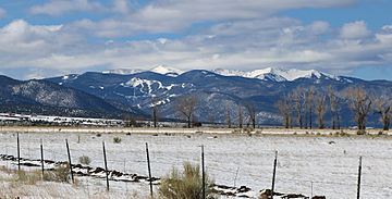
Some of the peaks in the Taos Mountains group, viewed from south of San Luis, Colorado.
|
|
| Highest point | |
| Elevation | 12,739 ft (3,883 m) NAVD 88 |
| Prominence | 2,934 ft (894 m) |
| Geography | |
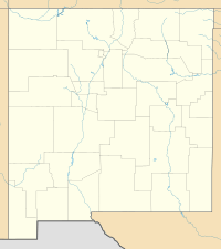
| Location | Taos County, New Mexico, U.S. |
| Parent range | Taos Mountains, Sangre de Cristo Mountains, Rocky Mountains |
| Topo map | USGS Latir Peak |
| Climbing | |
| Easiest route | Hike |
Venado Peak is a tall mountain in New Mexico, United States. It's part of the Taos Mountains, which are a smaller group within the larger Sangre de Cristo Mountains. These mountains are also part of the huge Rocky Mountains range. Venado Peak is found in Taos County, about 8 miles (13 km) northeast of a town called Questa. The very top of Venado Peak is the highest spot in the Latir Peak Wilderness area, which is part of the Carson National Forest. The name "Venado" means "deer" in Spanish.
Contents
About Venado Peak
Venado Peak is the highest point among the mountains north of the Red River. It is also the highest point southwest of Costilla Creek. In New Mexico, Venado Peak is the tenth highest mountain by how tall it is. It is also the sixth highest by its topographic prominence. Prominence means how much a peak rises above the land around it.
Nearby Mountains
Venado Peak is surrounded by other cool mountains. These include Latir Peak, which is 12,708 feet (3,873 meters) tall. There is also Virsylvia Peak, at 12,594 feet (3,839 meters). Cabresto Peak is 12,448 feet (3,794 meters) high. You can also find Baldy Mountain, which is 12,048 feet (3,672 meters) tall. Pinabete Peak is 11,948 feet (3,642 meters) high.
- The names "Latir" and "Virsylvia" have unknown meanings.
- "Cabresto" means "rope" or "halter" in Spanish.
- "Pinabete" means "pine tree" in Spanish.
Latir Peak is very well-known, even though it is not the tallest. The wilderness area around these peaks is named after Latir Peak. There are also nine small lakes on the northeast side of the mountains called Latir Lakes. A creek that drains these lakes is also named Latir. Pinabete Peak is not as tall as the others. But it looks very impressive from far away. It rises about 4,250 feet (1,295 meters) above the flat land nearby. It does this over a distance of about 4 miles (6 km).
Lakes and Access
Just south of the mountains, you will find Cabresto Creek. There is also Cabresto Lake, which is a popular place for fishing. The Forest Service has a campground there. The Latir Lakes and the entire northeast side of the mountains are privately owned. They belong to the Rio Costilla Cattle Association. You can visit these areas, but you usually need to pay a fee. On the southeast side of the mountains, there is a lake called Heart Lake.
You can reach the peaks from a few different places. One way is from Cabresto Lake. You can use trails like the Lake Fork, Bull Creek, and Heart Lake Trails. Another way to get to the peaks is from the Latir Lakes area.
Mountain Geology and Landscape
The Taos Mountains have a very old core. It is made of Precambrian metamorphic rock. This rock is about 1.7 billion years old. Around Venado Peak, you can also find younger Tertiary volcanic rocks. These include tuff, which is a type of rock made from volcanic ash. There are also remains of a "complex and mineral-rich caldera." A caldera is a large basin formed when a volcano collapses. This one formed about 25 million years ago.
Most of the mountain tops are wide and flat. They are covered with alpine tundra. This is a type of treeless grassland found in cold, high places. The tree line is between 11,000 feet (3,353 meters) and 12,000 feet (3,658 meters). This is the elevation above which trees cannot grow. A special feature of this mountain group is the large, gently sloped Latir Mesa. It lies south of Latir Peak. Its elevation is between 12,200 feet (3,719 meters) and 12,600 feet (3,840 meters).
See also
 In Spanish: Pico Venado para niños
 | James Van Der Zee |
 | Alma Thomas |
 | Ellis Wilson |
 | Margaret Taylor-Burroughs |


