
Sangre de Cristo Mountains facts for kids
Quick facts for kids Sangre de Cristo Mountains |
|
|---|---|

Blanca Peak
|
|
| Highest point | |
| Peak | Blanca Peak (East of Alamosa, Colorado) |
| Elevation | 14,351 ft (4,374 m) |
| Dimensions | |
| Length | 242 mi (389 km) north-south |
| Width | 120 mi (190 km) east-west |
| Area | 17,193 sq mi (44,530 km2) |
| Naming | |
| Etymology | Sangre de Cristo (Spanish: Blood of Christ) |
| Geography | |
| Country | United States |
| Parent range | Rocky Mountains |
The Sangre de Cristo Mountains are a beautiful mountain range in the United States. Their name means "Blood of Christ" in Spanish. These mountains are the southernmost part of the larger Rocky Mountains. You can find them in southern Colorado and northern New Mexico.
The range stretches from Poncha Pass in Colorado, going southeast and then south. It ends near Glorieta Pass, which is southeast of Santa Fe, New Mexico. In Colorado, many peaks are over 14,000 feet tall. All peaks in New Mexico that are over 13,000 feet are also found here.
The name "Sangre de Cristo" might come from the reddish colors seen at sunrise and sunset. This is especially true when the mountains are covered in snow. The exact story behind the name isn't clear. But people have used it since the early 1800s. Before that, people called them "The Snowies" or "La Sierra Nevada." One old story says "Sangre de Cristo" were the last words of a priest. He was said to have been killed by Native Americans.
Contents
Exploring the Sangre de Cristo Mountains


A lot of the Sangre de Cristo Mountains are part of National Forests. These include the Rio Grande National Forest and San Isabel National Forest in Colorado. In New Mexico, you'll find the Carson National Forest and Santa Fe National Forest. The United States Forest Service manages these public lands.
These areas are great for outdoor fun! People enjoy hunting, camping, and hiking here. You can also go mountain biking, backpacking, and climbing. In winter, cross-country and downhill skiing are popular.
The mountains also have two big wilderness areas. These are the Sangre de Cristo Wilderness in Colorado and the Pecos Wilderness in New Mexico. There are also smaller wilderness areas, like Latir Peak Wilderness. The Great Sand Dunes National Park and Preserve is on the southwest side of the mountains in Colorado. The National Park Service takes care of this special place.
Parts of the Sangre de Cristo Mountains
The Sangre de Cristo Mountains are split into different sections. These sections are described from north to south. Sometimes, people use "Sangre de Cristo Range" and "Sangre de Cristo Mountains" differently. They might mean just one part or the whole mountain system.
Sangre de Cristo Range
This is the biggest and most northern part of the Sangre de Cristo Mountains. It runs along the east side of the Rio Grande Rift. It stretches about 75 miles (120 km) from Poncha Pass to La Veta Pass. This part of the range separates the San Luis Valley in the west from the Arkansas River area in the east.
Crestones
The Crestones are a group of four very tall peaks. They are all over 14,000 feet (4,268 meters) high. These peaks are part of the Sangre de Cristo Range and are located above Crestone, Colorado.
Spanish Peaks
The Spanish Peaks are two mountains in Colorado. They are called West Spanish Peak (13,626 feet) and East Spanish Peak (12,860 feet). These peaks were named a National Natural Landmark in 1976. They show some of the best examples of igneous dikes. You can see these mountains from far away. They are visible from Colorado Springs, Colorado (133 miles north) and Raton, New Mexico (65 miles south).
Culebra Range
The Culebra Range runs north to south. It starts at La Veta Pass in Colorado and ends at Costilla Creek in New Mexico. Its highest point is Culebra Peak at 14,047 feet. This peak is special because it's the only 14,000-foot peak in Colorado on private land. People who want to climb Culebra Peak must pay a fee. Only a limited number of climbers are allowed each year. It is also the southernmost 14,000-foot peak in the U.S. Rockies.
Taos Mountains
The Taos Mountains are in the western part of the range. They go from Costilla Creek in the north to Tres Ritos, New Mexico in the south. This area includes Wheeler Peak, which is the highest point in New Mexico at 13,161 feet (4,013 meters). Wheeler Peak is part of the Wheeler Peak Wilderness. Other important peaks are Pueblo Peak (12,305 feet) and Latir Peak (12,708 feet). Williams Lake is located below Wheeler Peak.
Taos Ski Valley is just west of Wheeler Peak. Much of the middle part of the Taos Mountains is on Taos Pueblo land. When seen from Taos, locals call them "Taos Mountain."
Cimarron Range
The Cimarron Range is east of the Taos Mountains, across the Moreno Valley. It is a lower range. Its highest point is Baldy Mountain at 12,441 feet. The Philmont Scout Ranch is on the east side of the Cimarron Range.
Santa Fe Mountains
The Santa Fe Mountains are the southernmost part of the Sangre de Cristo Mountains. They are near Santa Fe, New Mexico. This group surrounds the Pecos Wilderness, which protects the source of the Pecos River. The highest point here is Truchas Peak, at 13,102 feet. Other notable peaks include Santa Fe Baldy (12,622 feet) and Jicarita Peak (12,835 feet). The Pecos Wilderness has many trails. It is popular for backpacking and fishing in its high mountain lakes.
Tallest Peaks in the Sangre de Cristo Mountains
| Rank | Mountain Peak | Subrange | Elevation | Prominence | Isolation | Image | Comment |
|---|---|---|---|---|---|---|---|
| 1 | Blanca Peak | Sierra Blanca | 14,351 ft 4374 m |
5,326 ft 1623 m |
103.4 mi 166.4 km |
 |
Blanca Peak in Colorado is the highest peak of the Sangre de Cristo mountains. |
| 2 | Crestone Peak | Crestones | 14,300 ft 4359 m |
4,554 ft 1388 m |
27.4 mi 44.1 km |
 |
Crestone Peak is a challenging climb with some tricky parts and a risk of falling rocks. (Image: Crestone Peak and Crestone Needle seen from the south) |
| 3 | Culebra Peak | Culebra Range | 14,053 ft 4283 m |
4,827 ft 1471 m |
35.5 mi 57.1 km |
 |
(Image: Big Costilla Peak in the Culebra Range, viewed from Valle Vidal.) |
| 4 | West Spanish Peak | Spanish Peaks | 13,631 ft 4155 m |
3,685 ft 1123 m |
20.4 mi 32.9 km |
 |
(Image: West Spanish Peak taken from the south) |
| 5 | Mount Herard PB | Sangre de Cristo Range | 13,325 ft 4062 m |
2,040 ft 622 m |
4.64 mi 7.47 km |
 |
(Image: Sangre de Cristo range from the Great Sand Dunes National Park) |
| 6 | Wheeler Peak NGS | Taos Mountains | 13,167 ft 4013 m |
3,409 ft 1039 m |
37.4 mi 60.1 km |
 |
Wheeler Peak is the highest peak in New Mexico. Taos Ski Valley is just west of Wheeler Peak. Much of the central Taos Mountains are on Taos Pueblo land. From Taos, people call it "Taos Mountain." |
| 7 | Bushnell Peak PB | Sangre de Cristo Range | 13,111 ft 3996 m |
2,405 ft 733 m |
11.07 mi 17.82 km |
||
| 8 | Truchas Peak NGS | Santa Fe Mountains PB | 13,107 ft 3995 m |
4,001 ft 1220 m |
42.4 mi 68.2 km |
 |
Truchas Peak is the highest point in the Santa Fe Mountains. (Image: Truchas Peak in winter from Española, New Mexico) |
| 9 | Venado Peak | Taos Mountains | 12,739 ft 3883 m |
2,954 ft 900 m |
11.80 mi 18.99 km |
.jpg) |
(Image: Taos Mountain at sunset.) |
| 10 | East Spanish Peak | Spanish Peaks | 12,688 ft 3867 m |
2,383 ft 726 m |
4.21 mi 6.78 km |
 |
East Spanish Peak is the lower of the two Spanish Peaks. These are two large igneous stocks that form an eastern part of the Culebra Range. (Image: Spanish Peaks as seen from I25, Huerfano county, Colorado) |
| 11 | Santa Fe Baldy NGS | Santa Fe Mountains PB | 12,632 ft 3850 m |
2,002 ft 610 m |
10.99 mi 17.69 km |
 |
Santa Fe Baldy is a tall summit in the Sangre de Cristo Mountains of New Mexico. It is about 15 miles (24 km) northeast of Santa Fe. It looks very big from Los Alamos and towns along the Rio Grande. But from Santa Fe, it looks smaller because of how its main ridge faces. Santa Fe Baldy is in the Pecos Wilderness within the Santa Fe National Forest. It sits on the water divide between the Rio Grande and the Pecos River. |
| 12 | Baldy Mountain NGS | Cimarron Range | 12,445 ft 3793 m |
2,701 ft 823 m |
11.33 mi 18.24 km |
 |
(Image: Baldy Peak summit ridge in the Cimarron Range.) |
| 13 | Greenhorn Mountain NGS | Wet Mountains | 12,352 ft 3765 m |
3,777 ft 1151 m |
26.4 mi 42.5 km |
 |
Greenhorn Mountain is the highest point in the Wet Mountains of southern Colorado. It is just tall enough to pass the tree line, which is about 11,500 feet (3,505 meters) here. You can see this huge mountain from Pueblo and along Interstate 25. The mountain is protected within the quiet Greenhorn Mountain Wilderness Area. You can reach it by a few trails and a nearby 4-wheel drive road. |
| 14 | Mount Zwischen PB | Sangre de Cristo Range | 12,011 ft 3661 m |
2,266 ft 691 m |
4.54 mi 7.31 km |
||
| 15 | Cerro Vista PB | Cerro Vista PB | 11,944 ft 3640 m |
2,519 ft 768 m |
14.19 mi 22.8 km |
||
| 16 | Mount Phillips PB | Cimarron Range | 11,745 ft 3580 m |
2,921 ft 890 m |
7.51 mi 12.09 km |
 |
Mount Phillips was once called Clear Creek Mountain. It is in Colfax County, about 11 miles (17 km) south of Baldy Mountain. It is part of the Cimarron Range. The peak was renamed in 1960 for Waite Phillips. He gave the land to the Boy Scouts of America. (Image: Mount Phillips (tallest mountain, at center) seen from Baldy Mountain) |
| 17 | Mount Mestas PB | Sierra Blanca | 11,574 ft 3528 m |
2,229 ft 679 m |
16.33 mi 26.3 km |
 |
|
| 18 | Iron Mountain PB | Sierra Blanca | 11,416 ft 3480 m |
1,951 ft 595 m |
6.95 mi 11.18 km |

How the Mountains Formed (Geology)
The Sangre de Cristo Mountains were pushed up during the Cenozoic Era. This happened during a time of mountain building called the Laramide orogeny. On their west side, they are next to the Rio Grande rift. On their east side, they have many reverse and thrust faults.
These faults show that the land moved up at least 4,200 meters (13,780 feet). Measurements of gravity suggest the mountains were pushed eastward a long way. This pushing caused older Precambrian basement rock to touch younger sedimentary rocks. This is true along the eastern edge, except where igneous rocks have pushed into the faults.
Images for kids
-
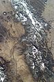
This picture was taken by an astronaut in February 2003. It shows the Sangre de Cristo Mountains from Santa Fe (bottom center) to north of Taos. The International Space Station took the photo. Santa Fe Baldy peak is at the lower right. The valley of the Rio Grande, including the Rio Grande Gorge, is west of the mountains.

See also
 In Spanish: Sierra de la Sangre de Cristo para niños
