Poncha Pass facts for kids
Quick facts for kids Poncha Pass |
|
|---|---|

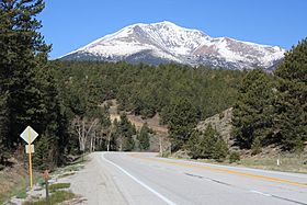
Looking west at Mount Ouray from the north side of Poncha Pass before the highway curves north.
|
|
| Elevation | 9,010 ft (2,746 m) |
| Traversed by | |
| Location | Chaffee / Saguache counties, Colorado, United States |
| Coordinates | 38°25′20″N 106°05′13″W / 38.42222°N 106.08694°W |
| Topo map | USGS Poncha Pass |
Poncha Pass is a mountain pass in south-central Colorado, United States. It sits at an elevation of 9,010 feet (2,745 meters). A mountain pass is like a low spot or a "saddle" between two mountains, making it easier to travel across a mountain range.
This pass connects two important areas. To the south is the San Luis Valley, and to the north is the valley of the Arkansas River. Poncha Pass is known for being one of the lowest mountain passes in Colorado. This means it's often easier to cross than many other high passes in the state.
The pass is located in a "saddle" between two large mountain ranges. To the southeast, you'll find the Sangre de Cristo Range. To the west and northwest is the Sawatch Range. The small town of Poncha Springs is about 6 miles (9 kilometers) north of the pass.
One great thing about Poncha Pass is how easy it is to use. The northern side has a gentle slope. The southern side has a moderate slope of about 5%. This pass stays open all year round. Even in winter, it usually doesn't cause problems for cars and trucks.
Poncha Pass is also important because of its location. It lies right on the border between Chaffee County and Saguache County. It also marks the boundary between two national forests: the San Isabel National Forest and the Rio Grande National Forest.
How People Travel Through Poncha Pass
Poncha Pass has been an important route for travelers for a long time. Today, a major highway crosses it. In the past, a train line used to go over the pass too.
Modern Highway Travel
Today, U.S. Highway 285 runs right over Poncha Pass. This highway is a key connection for many towns. It links the city of Alamosa to the south with Salida to the northeast. This makes it easy for people to drive between these areas.
Historic Rail Line
Before 1951, a special train line used to cross Poncha Pass. This was a narrow-gauge rail line. Narrow-gauge trains have tracks that are closer together than standard trains. This particular line was 3 feet (914 millimeters) wide.
The Denver & Rio Grande Western Railroad operated this train line. It connected Mears Junction in the north with Alamosa in the south. This railway was very important for transporting goods and people across the mountains. However, it stopped operating over the pass in 1951.
 | Aurelia Browder |
 | Nannie Helen Burroughs |
 | Michelle Alexander |

