
Crestone Peak facts for kids
Quick facts for kids Crestone Peak |
|
|---|---|

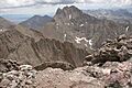
Crestone Peak seen from Kit Carson
|
|
| Highest point | |
| Elevation | 14,300 ft (4359 m) NAVD88 |
| Prominence | 4554 ft (1388 m) |
| Isolation | 27.4 mi (44.0 km) |
| Listing |
|
| Geography | |

Crestone Peak
Location in Colorado
|
|
| Location | High point of Saguache County, Colorado, United States. |
| Parent range | Sangre de Cristo Range, Highest summit of the Crestones |
| Topo map | USGS 7.5' topographic map Crestone Peak, Colorado |
| Climbing | |
| First ascent | 1916 by Eleanor Davis and party |
| Easiest route | Scramble (class 3) |
| Crestone East Peak | |
|---|---|
| Highest point | |
| Elevation | 14,266 ft (4,348 m) |
| Prominence | 80 ft (24 m) |
| Isolation | 0.08 mi (0.13 km) |
| Parent peak | Crestone Peak |
| Listing | Colorado county high points |
| Geography | |
| Location | Saguache County and high point of Custer County, Colorado, U.S. |
Crestone Peak is a very tall mountain in Colorado, United States. It is the seventh-highest mountain in Colorado that is over 14,000 feet tall. Mountains over 14,000 feet are often called "fourteeners."
This amazing peak is part of the Rocky Mountains and the Sangre de Cristo Range. It stands proudly in the Sangre de Cristo Wilderness, which is part of the Rio Grande National Forest. The mountain is about 5 miles (8.1 km) east of the Town of Crestone.
Crestone Peak rises about 7,000 feet above the San Luis Valley. It shares its name with a nearby mountain called Crestone Needle. These two peaks are part of a group of high mountains known as "The Crestones." This group also includes Kit Carson Peak, Challenger Point, Humboldt Peak, and Columbia Point.
Contents
Climbing Crestone Peak
Climbing Crestone Peak is an exciting adventure, but it is also very challenging. Most climbers start their journey from a "base camp." A base camp is a temporary camp where climbers stay before heading up the mountain.
South Colony Lakes Route
One popular way to climb Crestone Peak starts from the South Colony Lakes. This area is east of the peak. To reach it, you usually come from the Wet Mountain Valley. This route involves climbing almost 6,000 feet (1,800 meters) in height!
The path leads to a flat area called "The Pool Table." From there, climbers go up a long, steep gully on the northwest side of Crestone Peak. This part can be tricky because small rocks might fall, so wearing a climbing helmet is a good idea.
Cottonwood Creek Route
Another way to climb Crestone Peak is the Cottonwood Creek route. This route starts from the San Luis Valley on the west side. You follow Cottonwood Creek up to Cottonwood Lake.
The trail starts out clear, but it can become harder to follow higher up. Eventually, it connects with the main route from South Colony Lakes. From there, climbers can access the South Face route of Crestone Peak.
Safety Tips for Climbers
Crestone Peak is known for being one of the more difficult fourteeners to climb in Colorado. Accidents can happen, sometimes due to falls or lightning. During summer, lightning storms are common in the Sangre de Cristos, so it's important to start climbs early and be off the mountain before afternoon storms hit.
Connecting Peaks
From the top of Crestone Peak, you can try to climb to the summit of Crestone Needle. This is a technical climb that requires ropes (Class 5). However, most climbers choose to climb Crestone Peak and Crestone Needle on separate trips.

Images for kids
-
Crestone Peak seen from Kit Carson
See also
 In Spanish: Pico Crestone para niños
