
Baldy Mountain (Colfax County, New Mexico) facts for kids
Quick facts for kids Baldy Mountain |
|
|---|---|

Baldy Mountain from Copper Park camp
|
|
| Highest point | |
| Elevation | 12,441 ft (3,792 m) NAVD 88 |
| Prominence | 2,681 ft (817 m) |
| Geography | |

Baldy Mountain
Location in New Mexico
|
|
| Parent range | Cimarron Range, Sangre de Cristo Mountains |
| Topo map | USGS Baldy Mountain |
Baldy Mountain, also known as Baldy Peak or Mount Baldy, is a very tall mountain in New Mexico. It is the highest point in the Cimarron Range. This range is part of the larger Sangre de Cristo Mountains.
The mountain is located in Colfax County. It is about 6 miles (9.7 km) northeast of a town called Eagle Nest. Baldy Mountain rises sharply from the Moreno Valley to its west. It reaches a total height of 12,441 feet (3,792 meters).
Baldy Mountain and Philmont Scout Ranch
Baldy Mountain is an important part of the Boy Scouts of America's Philmont Scout Ranch. This ranch is a huge outdoor adventure camp. The eastern side of Baldy Mountain has many small camps for Scouts.
In 1963, a man named Norton Clapp bought a large area of land around the mountain. He then gave this land to the Boy Scouts of America. This made Baldy Mountain a special place for many young adventurers.
Mining History of Baldy Mountain
People started digging for valuable metals on Baldy Mountain a long time ago. This activity is called mining. Copper and gold were found here starting in 1866.
The very top of Baldy Mountain was once a copper mine called the Mystic Lode. Other mines were also nearby, like the Aztec and French Henry mines. You can still see signs of these old mines on the mountain slopes today.
Miners dug about 70 miles (113 km) of tunnels inside the mountain. Over time, a lot of gold was found. The gold found in the mountain was worth about $4 million.
Gallery
-
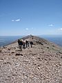
The top ridge of Baldy Mountain.
-
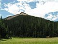
Baldy Mountain seen from Copper Park at Philmont Scout Ranch.
-
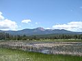
Baldy Mountain as viewed from Wilson Mesa.
-
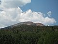
Looking at the southern side of Mount Baldy.


