
Wet Mountains facts for kids
Quick facts for kids Wet Mountains |
|
|---|---|

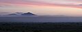
View of Wet Mountain Valley, west of mountain range
|
|
| Highest point | |
| Peak | Greenhorn Mountain |
| Elevation | 3,763 m (12,346 ft) |
| Dimensions | |
| Length | 20 mi (32 km) Nw-SE |
| Naming | |
| Native name | Sierra Mojada (Spanish) |
| Geography | |

Location in Colorado
|
|
| Country | United States |
| Range coordinates | 38°10′N 105°12′W / 38.167°N 105.200°W |
| Parent range | Sangre de Cristo Mountains, Rocky Mountains |
The Wet Mountains are a small mountain range located in southern Colorado, USA. They get their name because of how much snow they receive in the winter! These mountains are part of a larger group called the Sangre de Cristo Mountains, which are themselves a part of the huge Rocky Mountains System.
Sometimes, the Wet Mountains are also called by other names like Cuerno Verde, Greenhorn Mountains, or Sierra Mojada.
Contents
Where are the Wet Mountains Located?
Most of the Wet Mountains are found in Custer County. However, parts of the range, including Greenhorn Mountain, stretch into Huerfano County and Pueblo County. The range runs for about 20 miles (32 kilometers). It goes from U.S. Highway 50 in the north down to the town of Walsenburg in the south.
The Wet Mountains form the eastern edge of the Wet Mountain Valley. On the western side of this valley, you'll find the Sangre de Cristo Mountains.
What is the Tallest Peak?
The highest point in the Wet Mountains is Greenhorn Mountain. It has several peaks, and the very top one reaches an amazing 12,346 feet (3,763 meters) high! Greenhorn Peak, St. Charles Peak, and North Peak are all so tall that they go above the tree line. This means no trees can grow there because it's too cold and windy.
Towns and Communities in the Area
The Wet Mountain Valley next to the mountains has two small towns: Westcliffe and Silver Cliff.
Inside the mountains themselves, you'll find a few roads and communities:
- Highway 96 winds through a place called Hardscrabble Canyon down to Wetmore. It's one of the main ways to get out of the valley.
- Highway 165 travels through the range to Rye and Colorado City. Along this highway, you can visit Lake Isabel and the unique Bishop's Castle.
- Other towns include Beulah and Rosita. Rosita is now a ghost town. It was once a busy place for gold and silver mining many years ago.
How Were the Wet Mountains Formed?

The Wet Mountains were created by a process called uplift. This is when large sections of the Earth's crust are pushed upwards. The core of these mountains is made of very old granitic rocks. These rocks formed a long, arched shape called an anticline, which was then broken by faults.
The mountains also have younger layers of rock, called strata, around their edges. These rocks formed between 38 and 29 million years ago. They include volcanic rocks, which means there was once volcanic activity in this area.
Images for kids
-
View of Wet Mountain Valley, west of mountain range
-
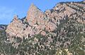
Granite rock formation in the Wet Mountains.
See also
 In Spanish: Sierra Mojada (Colorado) para niños
