Huerfano County, Colorado facts for kids
Quick facts for kids
Huerfano County
|
|
|---|---|
| County of Huerfano | |

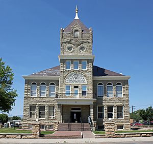
Huerfano County Courthouse and Jail
|
|

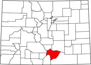
Location within the U.S. state of Colorado
|
|
| Country | |
| State | |
| Established | November 1, 1861 |
| Named for | Huerfano Butte |
| County seat | Walsenburg |
| Largest city | Walsenburg |
| Area | |
| • Total | 1,593 sq mi (4,130 km2) |
| • Land | 1,591 sq mi (4,120 km2) |
| • Water | 2.2 sq mi (6 km2) 0.1% |
| Highest elevation | 14,351 ft (4,374 m) |
| Population
(2020)
|
|
| • Total | 6,820 |
| • Density | 4.2/sq mi (1.6/km2) |
| Time zone | UTC−7 (Mountain) |
| • Summer (DST) | UTC−6 (MDT) |
| Area code | 719 |
| FIPS code | 08055 |
| GNIS feature ID | 198143 |
| Website | www.huerfano.us |
Huerfano County is a county in the state of Colorado, USA. In 2020, about 6,820 people lived there. The main town and county seat is Walsenburg.
The county's name comes from the Spanish word huérfano, which means "orphan". It was named after the Huerfano Butte, a famous local landmark. In the early 1900s, Huerfano County grew quickly because a lot of coal was found there. After World War II, when less coal was needed, the economy of Walsenburg and Huerfano County slowly declined until 2015.
Contents
History of Huerfano County

Huerfano County was one of the first 17 counties created in the Territory of Colorado. This happened on November 1, 1861. At first, it was much bigger than it is today.
Later, on November 2, 1870, a new county called Greenwood County was formed. It was made from land that used to belong to the Cheyenne and Arapaho tribes, and also from the eastern part of Huerfano County.
People have told many stories about hidden gold treasures in the hills and mountains of Huerfano County. These treasures are said to be from old Spanish times and Native American groups, including the Arapahoe Princess Treasure. There were also two old Spanish forts located in Huerfano County.
The Colorado Coalfield War
Huerfano County and its neighbor, Las Animas County, were at the center of a big event called the Colorado Coalfield War. This was a major strike by coal miners from 1913 to 1914. The miners were protesting against the Colorado Fuel and Iron company, which was owned by John D. Rockefeller Jr..
The town of Walsenburg and other places along the Colorado and Southern Railway were very important during this conflict. Both the striking miners and the Colorado National Guard wanted control of these areas. This led to many gun battles in and around the towns with train stops.
Geography of Huerfano County
Huerfano County covers a total area of about 1,593 square miles. Most of this area, about 1,591 square miles, is land. Only a small part, about 2.2 square miles (or 0.1%), is water.
Fun Things to Do in Huerfano County

The county's tourism group calls the area "Southern Colorado's Spanish Peaks Country." Many visitors come to see the Spanish Peaks. These mountains offer lots of outdoor activities like mountain climbing, hiking, hunting, and sightseeing.
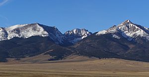
In the western part of the county, you can find the tall peaks of the Sangre de Cristo Range. This mountain range includes several "fourteeners," which are mountains over 14,000 feet high.
The towns of La Veta and Cuchara have art galleries and places to stay.
A new park, the Cuchara Mountain Park, opened in 2017. It uses the land that was once the Cuchara Ski Resort, which is now closed.
Huerfano County is also a great place for people who study rocks and the Earth. There are over 500 dikes (rock formations) around the Spanish Peaks. You can also see many other interesting rock formations, like the Dakota Formation.
Lathrop State Park is a good spot for hiking, camping, picnicking, and fishing. Right next to the park, the city of Walsenburg has a public golf course with nine holes.
People of Huerfano County
| Historical population | |||
|---|---|---|---|
| Census | Pop. | %± | |
| 1870 | 2,250 | — | |
| 1880 | 4,124 | 83.3% | |
| 1890 | 6,882 | 66.9% | |
| 1900 | 8,395 | 22.0% | |
| 1910 | 13,320 | 58.7% | |
| 1920 | 16,879 | 26.7% | |
| 1930 | 17,062 | 1.1% | |
| 1940 | 16,088 | −5.7% | |
| 1950 | 10,549 | −34.4% | |
| 1960 | 7,867 | −25.4% | |
| 1970 | 6,590 | −16.2% | |
| 1980 | 6,440 | −2.3% | |
| 1990 | 6,009 | −6.7% | |
| 2000 | 7,862 | 30.8% | |
| 2010 | 6,711 | −14.6% | |
| 2020 | 6,820 | 1.6% | |
| 2023 (est.) | 7,055 | 5.1% | |
| U.S. Decennial Census 1790-1960 1900-1990 1990-2000 2010-2020 |
|||
In 2000, there were 7,862 people living in Huerfano County. These people lived in 3,082 households, and 1,920 of these were families. The county had about 5 people per square mile. There were also 4,599 housing units, with about 3 units per square mile.
Most people in the county were White (80.96%). Other groups included Black or African American (2.75%), Native American (2.70%), Asian (0.39%), and Pacific Islander (0.08%). About 9.41% were from other races, and 3.71% were from two or more races. A large part of the population, 35.14%, identified as Hispanic or Latino.
Out of all the households, 25% had children under 18 living with them. About 48.4% were married couples living together. About 10.4% had a female head of household with no husband present. And 37.7% were not families. About 32.8% of all households were single individuals, and 14.1% had someone living alone who was 65 or older. On average, a household had 2.25 people, and a family had 2.85 people.
The population was spread out by age:
- 20.9% were under 18 years old.
- 7.3% were from 18 to 24 years old.
- 27.4% were from 25 to 44 years old.
- 27.4% were from 45 to 64 years old.
- 17.0% were 65 years or older.
The average age in the county was 42 years. For every 100 females, there were about 118.8 males. For every 100 females aged 18 and over, there were about 122.8 males.
The average income for a household in the county was $25,775. For a family, the average income was $32,664. Men earned about $24,209 on average, while women earned about $21,048. The average income per person in the county was $15,242. About 14.1% of families and 18% of the total population lived below the poverty line. This included 23.7% of those under 18 and 11.9% of those aged 65 or over.
See also
 In Spanish: Condado de Huérfano para niños
 | Anna J. Cooper |
 | Mary McLeod Bethune |
 | Lillie Mae Bradford |

