
Beulah, Colorado facts for kids
Quick facts for kids
Beulah, Colorado
|
|
|---|---|

Beulah's gas station, general store, and post office
|
|

Beulah, Colorado
Location in Colorado
|
|
| Country | |
| State | |
| County | Pueblo County |
| Settled | 1862 |
| Elevation | 6,381 ft (1,945 m) |
| Time zone | UTC-7 (MST) |
| • Summer (DST) | UTC-6 (MDT) |
| ZIP Code |
81023
|
| Area code(s) | 719 |
Beulah is a small, unincorporated community in Pueblo County, Colorado. This means it's a settlement without its own local government. It's part of the Beulah Valley area. Beulah has its own post office with the ZIP code 81023. You can find Beulah along State Highway 78. It's about 21 miles southwest of the city of Pueblo. The community sits in the foothills of the Wet Mountains.
Contents
History of Beulah
How Beulah Got Its Name
The area where Beulah is now was first settled in 1862. It was originally called Mace's Hole. This unusual name came from a bandit named Juan Maes. He used the valley as a secret hideout.
A Post Office opened in Mace's Hole on April 23, 1873. A local preacher didn't like the town's name. He thought it sounded bad. He suggested a new name from the Bible: Beulah. The name Beulah comes from a Hebrew word meaning "married." On October 25, 1876, the town officially changed its name to Beulah.
Geography and Climate of Beulah
Where is Beulah Located?
Beulah is located at coordinates 38°04′33″N 104°59′10″W / 38.07583°N 104.98611°W. It sits in a beautiful valley. The Wet Mountains are to the west. Mount Signal is to the south and southeast. A tall ridge forms the north and east sides of the valley.
The valley itself is quite high up. Its elevations range from about 6,150 to 7,100 feet. Four creeks flow through the valley: North Creek, Middle Creek, Squirrel Creek, and South Creek. They all join together as they flow east. Eventually, they form the North St. Charles River. This river then flows into the St. Charles River. Finally, it drains into the Arkansas River.
Beulah's Weather Patterns
Beulah's location in the mountains means it gets a lot of precipitation. This includes heavy snowfall in winter. It also gets significant rain in warmer months. This is often due to the North American Monsoon.
Summers in Beulah are usually mild. The nights are cool. Temperatures rarely stay above 60°F at night. High temperatures can reach 90°F or more on about 33 days each year. The growing season for plants lasts about 140 days. This is from early May until the end of September.
Winters are generally mild. Sometimes, temperatures can even go above 70°F. However, there can also be periods of several days below freezing. Snow can fall from September all the way through late May.
Storms and Records
Thunderstorms are common in the warmer months. They happen about 42 days a year. Hail falls on about five days. Sometimes, severe thunderstorms can affect the valley. These storms can bring large hail. For example, on June 20, 2001, hail over two inches wide fell. Tornadoes have been seen near the valley. This is especially true in July and August. However, no tornado has directly hit Beulah itself as of June 2015.
The highest temperature ever recorded in Beulah was 101°F. This happened on June 26, 1994, and again on August 2, 2008. The lowest temperature recorded was -18°F. This was on February 2, 2011. Beulah gets about 19.3 inches of rain each year on average. It also gets a lot of snow. The average yearly snowfall is about 120 inches.
Images for kids
-
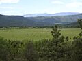
A picture of the town taken from the south facing mountain.
-
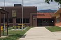
The local K-8 magnet school, Beulah School of Natural Sciences.
-
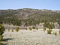
The Northcreek mountain range.


