Blanca Peak facts for kids
Quick facts for kids Blanca Peak |
|
|---|---|
| Sisnaajiní | |

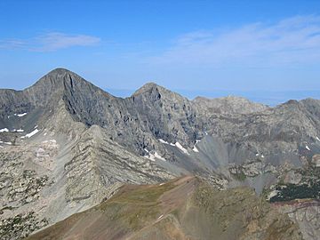
View of Blanca Peak (left of center) from Mt. Lindsey
|
|
| Highest point | |
| Elevation | 14,351 ft (4374 m) NAVD88 |
| Prominence | 5326 ft (1623 m) |
| Isolation | 103.4 mi (166.4 km) |
| Listing |
|
| Geography | |
| Parent range | Highest summit of the Sangre de Cristo Mountains, Sangre de Cristo Range, and Sierra Blanca Massif |
| Topo map | USGS 7.5' topographic map Blanca Peak, Colorado |
| Climbing | |
| First ascent | August 14, 1874 by the Wheeler Survey (first recorded) |
| Easiest route | Northwest Face/North Ridge: Scramble (Class 2/easy Class 3) |
| Blanca Peak Tripoint | |
|---|---|
| Highest point | |
| Elevation | 14,326 ft (4,367 m) |
| Parent peak | Blanca Peak |
| Listing | Colorado county high points |
| Geography | |
| Location | Tripoint of Alamosa, Costilla, and Huerfano counties, Colorado, US High point of Huerfano County. |
Blanca Peak is a very tall mountain in Colorado, United States. It is the fourth highest mountain in the Rocky Mountains of North America. It is also the fourth highest peak in the state of Colorado.
Blanca Peak is known as an "ultra-prominent" peak. This means it stands much higher than the land around it. It rises to 14,351 feet (4,374 m) above sea level. This makes it the highest point in the Sierra Blanca Massif, the Sangre de Cristo Range, and the Sangre de Cristo Mountains.
Because it is over 14,000 feet tall, Blanca Peak is called a "fourteener." It is located about 9.6 miles (15.5 km) north of the Town of Blanca. The mountain is the highest point in both Alamosa and Costilla counties. It is also the highest point in the entire area drained by the Rio Grande river.
Long ago, two glaciers called North and South Blanca Glaciers were on the steep North Face of Blanca Peak. They melted away sometime after 1903. Blanca Peak is taller than any other point in the United States that is east of its location.
The Blanca Peak Tripoint is a special spot near Blanca Peak. It is where Alamosa, Costilla, and Huerfano counties all meet. This spot is about 251 feet (77 m) northeast of the main Blanca Peak summit. It is the highest point in Huerfano County.
Contents
Exploring Blanca Peak's Location
Blanca Peak is found at the southern end of the Sangre de Cristo Range. This range is part of the larger Sangre de Cristo Mountains. Blanca Peak is the tallest mountain in both of these ranges. It sits about 20 miles (32 km) east-northeast of the town of Alamosa. About 15 miles (24 km) to the north-northwest is the famous Great Sand Dunes National Park and Preserve.
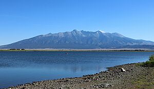
Blanca Peak is special not just for its height, but also for how much it stands out. It rises sharply from the San Luis Valley to the west. For example, it climbs almost 7,000 feet (2,100 m) from the valley floor in just 6 miles (9.7 km). This makes it look very impressive.
Blanca is also the third most "topographically prominent" peak in Colorado. This means it has a very high peak compared to the lowest point connecting it to any higher mountain. It is separated from the taller peaks in the Sawatch Range by a relatively low spot called Poncha Pass.
How to Access Blanca Peak
Blanca Peak is the source of three main creeks. Holbrook Creek flows from the west side. This area includes beautiful lakes like Crater Lake, Blue Lakes, and Como Lake. A very difficult four-wheel drive road goes up to Como Lake at 11,750 feet (3,580 m). This road is the most common way for people to get close to Blanca Peak. Most vehicles can only go up to between 8,000 feet (2,400 m) and 10,000 feet (3,000 m) on this road. The Como Lake Road is known as the most challenging four-wheel drive road in Colorado.
The Huerfano River starts on the north side of Blanca Peak. There is another road that begins as a regular road and then becomes a four-wheel drive road. This road is not as hard as the Como Lake Road. It provides access for people who want to do technical climbing on the North Face of Blanca Peak. Blanca Creek flows from the south side of the peak. Little Ute Creek comes from the Winchell Lakes on the southeast side. However, these areas are on private land, so they are not used to reach the peak.
Nearby Mountains
Three other "fourteeners" are close to Blanca Peak. These are Mount Lindsey to the east, Ellingwood Point to the north, and Little Bear Peak to the southwest. Ellingwood Point is connected to Blanca by a short, high ridge. Climbers often climb both Blanca and Ellingwood Point together. Little Bear Peak also has a high ridge connecting it to Blanca. However, this connection is a very difficult technical route. It is only recommended for climbers with a lot of experience.
Blanca Peak's Ancient Rocks
The rocks that make up Blanca Peak are a type of granite. These rocks are very, very old. Scientists have found that they are about 1.8 billion years old. To give you an idea, the major parts of the Wet Mountains to the east and the Front Range to the northeast are also about 1.8 billion years old. However, the Sangre de Cristo Range to the north and the Culebra Range to the south have younger rocks. Their rocks are between 250 and 300 million years old.
A Mountain of History and Meaning
Blanca Peak holds deep meaning for the Navajo people. They call it the Sacred Mountain of the East: Sisnaajiní. This name means "Dawn" or "White Shell Mountain." The Navajo believe this mountain marks the eastern edge of their traditional homeland, called the Dinetah.
The mountain is linked to the color white. It is said to be covered in daylight and the colors of dawn. The Navajo believe it is fastened to the ground with lightning. They also see it as a male mountain.
The first recorded climb of Blanca Peak happened on August 14, 1874. This was done by a group called the Wheeler Survey. But when they reached the top, they found something surprising. They saw evidence of a stone structure. It might have been built by the Ute people or by early Spanish explorers.
Other Names for Blanca Peak
- Blanca Peak
- Mount Blanca
- Sierra Blanca Peak
- Sierra Blanca
- Sisnaajiní
See also
 In Spanish: Pico Blanca para niños
 | Bessie Coleman |
 | Spann Watson |
 | Jill E. Brown |
 | Sherman W. White |


