
Little Bear Peak facts for kids
Quick facts for kids Little Bear Peak |
|
|---|---|

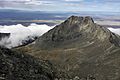
Little Bear Peak from the Southwest Ridge
|
|
| Highest point | |
| Elevation | 14,037 ft (4,278 m) |
| Prominence | 377 ft (115 m) |
| Isolation | 0.96 mi (1.54 km) |
| Parent peak | Blanca Peak |
| Listing | Colorado Fourteener 44th |
| Geography | |

Little Bear Peak
Location in Colorado
|
|
| Location | Alamosa and Costilla counties, Colorado, United States |
| Parent range | Sangre de Cristo Range, Sierra Blanca Massif |
| Topo map | USGS 7.5' topographic map Blanca Peak, Colorado |
| Climbing | |
| Easiest route | exposed scramble (Class 4) |
Little Bear Peak is a very tall mountain in the Sangre de Cristo Range. This mountain range is part of the larger Rocky Mountains in North America. Little Bear Peak is a "fourteener" because it is over 14,000 feet high. It stands at 14,037-foot (4,278 m) tall.
The peak is found in Colorado, United States. It sits on the border between Alamosa and Costilla counties. Little Bear Peak is also part of the Sierra Blanca Massif, a group of mountains. It is located southwest of Blanca Peak, which is the highest point in this mountain group.
Contents
Exploring Little Bear Peak
Little Bear Peak is made of very old rock called granite. This granite is about 1.8 billion years old! Like other mountains in the Sierra Blanca Massif, Little Bear Peak rises high above the San Luis Valley. It stands almost 7,000 feet above the valley floor.
The peak is on a long ridge that separates two valleys. These valleys were carved out by ancient glaciers.
Climbing Challenges
Little Bear Peak is known as one of the most challenging and difficult "fourteeners" to climb. Even though it doesn't stick up much higher than the land around it, its climbing routes are tough.
The main climbing path goes through a section called the "Hourglass." This part is about 300 feet long. It's a smooth granite slab where rocks can often fall. There's also another difficult route on the northwest side of the mountain. This path starts from the Blue Lakes and climbs over 6,200 feet. The easiest ways to climb Little Bear Peak are on its eastern side.

Connecting to Blanca Peak
The ridge that connects Little Bear Peak to Blanca Peak is one of the most challenging mountain traverses in Colorado. A traverse means moving along a ridge from one peak to another. Experts say it's easier to go from Little Bear to Blanca Peak.
Once climbers start this traverse, they are committed to finishing it. There are only a few safe spots to get off the rock. These spots lead down into Blanca Basin.
Little Bear Peak is split by a boundary line. The western side is part of the Rio Grande National Forest. The eastern side is private property. The mountain also sits on the border between Alamosa County and Costilla County.
Historical Names
Over time, Little Bear Peak has been known by a few names:
- Little Bear
- Little Bear Peak
- West Peak
Images for kids
-
Little Bear Peak from Blanca Peak summit
-
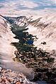
Looking down on Como Lake from the summit of Little Bear


