
West Spanish Peak facts for kids
Quick facts for kids West Spanish Peak |
|
|---|---|

West Spanish Peak from the south
|
|
| Highest point | |
| Elevation | 13,631 ft (4,155 m) |
| Prominence | 3,686 ft (1,123 m) |
| Isolation | 20.49 mi (32.98 km) |
| Listing |
|
| Geography | |

West Spanish Peak
Location in Colorado
|
|
| Location | Huerfano County and the high point of Las Animas County, Colorado, United States |
| Parent range | Culebra Range, Highest summit of the Spanish Peaks |
| Topo map | USGS 7.5' topographic map Spanish Peaks, Colorado |
| Climbing | |
| Easiest route | West Ridge: hike/scramble, class 2 |
West Spanish Peak is a very tall and noticeable mountain in the Rocky Mountains of North America. It is the higher of the two mountains known as the Spanish Peaks. This impressive peak stands at about 13,631 feet (4,155 meters) high.
You can find West Spanish Peak in the Spanish Peaks Wilderness area, which is part of the San Isabel National Forest. It's located about 9 miles (14.7 kilometers) south of the town of La Veta, Colorado, in the United States. The mountain sits right on the border between Huerfano and Las Animas counties. In fact, the very top of West Spanish Peak is the highest point in Las Animas County, Colorado.
The Spanish Peaks are two large rock formations that stick out from the main Sangre de Cristo Mountains. West Spanish Peak is special because it's the easternmost mountain in the United States that is over 13,123 feet (4,000 meters) tall. Because it's so far east, away from other tall mountains, it looks incredibly tall from almost every direction. For example, it rises over 6,000 feet (1,828 meters) in just 6.5 miles (10.5 kilometers) on both its north and south sides. Even though it's not a "fourteener" (a mountain over 14,000 feet), it's the twelfth most prominent peak in Colorado. This means it stands out a lot from the land around it.
What is West Spanish Peak Made Of?
West Spanish Peak is what's left of a large rock formation called an igneous stock. This stock is mostly made of a rock called quartz syenite. It formed about 24.59 million years ago. What's really cool is that over 500 rock walls, called dikes, spread out like spokes from the center of the peak.
Hiking and Climbing West Spanish Peak
If you want to climb West Spanish Peak, the most common way to start is at Cordova Pass. This pass is a high point (about 11,248 feet or 3,428 meters) located to the west of the peak.
- The Trail: From Cordova Pass, you follow a trail for about 2 miles (3.2 kilometers) until you reach the treeline, where the trees stop growing.
- Above Treeline: After the treeline, the path gets a bit rougher. You'll be walking on loose rocks (called scree or talus) up the southwest ridge of the peak for another 1.5 miles (2.4 kilometers).
- Staying on Track: The path can be tricky and might lead you into very loose scree. It's easier if you stay to the left and close to the main ridge.
- Near the Top: Around 13,000 feet (3,962 meters), you'll see a large shale rock formation to your right. Sometimes, there's a small pool of warm water at its base.
- The Summit Ridge: Once you get onto the main part of the top ridge, it's an easier walk to the very summit. This top ridge is usually 30 to 100 feet (9 to 30 meters) wide and about 0.5 miles (0.8 kilometers) long before it starts to go downhill on the east side. The north and south sides of the mountain are very steep.
- At the Summit: At the very top, you'll find a large pile of rocks called a cairn. Inside, there's usually a PVC tube with a "sign-in" sheet where climbers can write their names.
Safety Tips:
- This mountain is very dangerous when there is snow on the ground.
- The best time to climb is from early June through late October.
- Be aware that thunderstorms and lightning can be common in July, August, and September. Always check the weather forecast before you go!
Images for kids
-
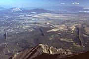
Igneous dikes, looking north from West Spanish Peak.
-
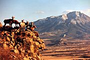
Sunset shot of some Bighorn sheep ewes with the West Spanish Peak in the background.
-
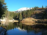
West Spanish Peak in November.


