Southern Ute Indian Reservation facts for kids
Quick facts for kids
Southern Ute Indian Reservation
Kapuuta-wa Moghwachi Núuchi-u
|
||
|---|---|---|
|
||
| Tribe | Southern Ute | |
| Country | United States | |
| State | Colorado | |
| Counties | La Plata Archuleta Montezuma Counties |
|
| Headquarters | Ignacio | |
| Government | ||
| • Body | Tribal Council | |
| Population
(2020)
|
||
| • Total | 12,321 | |
| Website | southernute-nsn.gov | |
The Southern Ute Indian Reservation is a special area of land in southwestern Colorado, United States. It is close to the border with New Mexico. This land is home to the Southern Ute people.
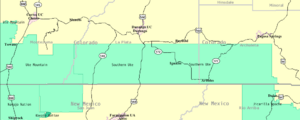
The reservation stretches across parts of three counties: La Plata, Archuleta, and Montezuma. It covers a large area of about 1,059 square miles (2,742 square kilometers). The main towns on the reservation are Ignacio and Arboles. The Ute people call their land Kapuuta-wa Moghwachi Núuchi-u.
Contents
History of the Southern Ute People
The Southern Ute Indian Tribes are made up of different groups, or bands. These include the Mouache, Capote, and Weeminuche bands. The Weeminuche band is now part of the Ute Mountain Ute Tribe.
Understanding the Historic Ute Bands
The Ute people lived in different areas and had unique ways of life. Here are the main Southern Ute bands:
The Capote Band
The Capote band, known as Kapuuta Núuchi, lived in the eastern part of the Great Divide. Their lands were south of the Conejos River and east of the Rio Grande. They also lived in the San Luis Valley and along the Animas River. Their main areas were near what is now Chama and Tierra Amarilla in Rio Arriba County.
The Capote people traded with the Puebloan peoples. They sometimes had conflicts with other groups from the southern plains. This was because they were friends with the Ollero band of the Jicarilla Apache.
The Mouache Band
The Mouache band, called Moghwachi Núuchi, lived along the eastern foothills of the Rocky Mountains. Their territory stretched from Denver in the north to Las Vegas, New Mexico in the south. They traded with northern Puebloan peoples, especially with Taos Pueblo. Because of this, they were often called "Taos-Ute."
After they started using horses, the Mouache and their friends, the Llanero band of the Jicarilla Apache, traveled southeast. They went as far as the Texas Panhandle.
Agreements with the U.S. Government
Over time, the Ute people made several agreements, called treaties, with the United States government. These treaties often changed the amount of land the Ute people had.
In 1868, a treaty created a large reservation for the Ute people. It covered about one-third of what is now Colorado. Most of this land was in the mountains. However, when valuable metals were found, settlers wanted access to the land.
In 1873, the Brunot Agreement was made. This agreement greatly reduced the size of the Ute reservation. It became the narrow strip of land that is the Southern Ute Reservation today. The U.S. government also made other treaties with Ute bands in 1855, 1865, and 1866. However, the U.S. Senate did not approve these agreements.
The 1865 treaty offered the Ute people land in Utah and money each year. It also banned alcohol and planned for a school to teach practical skills.
In 1895, the Hunter Act was passed. This law divided the reservation land into smaller plots for families in the Mouache and Capote tribes. The Weeminuche tribe had tried to move to San Juan County, Utah, but that plan did not happen. So, they returned to Colorado. They set up camps on the western part of the Southern Ute Reservation. After these land divisions, over 500,000 acres of the reservation were opened to non-Native settlers.
Geography of the Southern Ute Reservation
The Southern Ute Indian Reservation is located in the southwestern corner of Colorado. The eastern part of the reservation is covered in forests. These areas have high elevations, reaching over 9,000 feet (2,743 meters).
The western part of the reservation is mostly dry, flat-topped hills called mesas. The reservation forms a strip of land. It is about 15 miles (24 kilometers) from north to south. It stretches about 110 miles (177 kilometers) from east to west.
How the Southern Ute Tribe is Governed
The Southern Ute Indian Tribe is a federally recognized Ute tribe. This means the U.S. government officially recognizes them as a sovereign nation. The tribe's reservation was set up in 1873.
The Southern Utes are made up of the Mouache and Capote bands. Their government follows rules from the Indian Reorganization Act of 1934. A tribal council leads the government, with a chairman as the main leader.
Many important leaders have served the tribe. Leonard C. Burch was chairman for many years in the late 1900s. In 2008, Matthew Box was elected chairman. Pearl Casias became the first chairwoman in 2011. Jimmy Newton served as chairman from 2012 until his passing in 2014. Clement Frost followed him, retiring in 2017. Christine Baker-Sage was elected chairwoman in December 2017. Currently, Melvin J. Baker was elected Tribal Chairman in December 2020.
Economy and Environment
The Southern Ute Indian Tribe has a special project to capture coalbed methane. This project helps reduce greenhouse gas emissions. Between 2009 and 2017, it reduced emissions by as much as 379,000 metric tons of carbon dioxide.
This project helps the environment. It also brings in money for the tribe. The gas is sent to natural gas pipelines. The tribe also earns money by selling carbon offsets. Carbon offsets are like credits for reducing pollution.
Notable People from the Southern Ute Tribe
- Joseph Rael (born 1935): A famous dancer, writer, and spiritual leader.
- Sapiah (1840–1936): A Ute chief who led his people from about 1870 until his death.
See also
- Bibliography of Colorado
- Geography of Colorado
- History of Colorado
- Index of Colorado-related articles
- List of Colorado-related lists
- Outline of Colorado
- Ute people
- Capote Band of Utes
- Muache Band of Utes
- Uintah and Ouray Indian Reservation
- Ute Mountain Ute Tribe
 | Dorothy Vaughan |
 | Charles Henry Turner |
 | Hildrus Poindexter |
 | Henry Cecil McBay |


