Geography of Colorado facts for kids
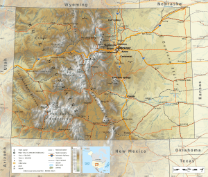
Colorado is a state in the United States with many different types of land. You can find tall mountains, wide plains, dry deserts, deep canyons, and flat-topped hills called mesas. Colorado is a "landlocked" state, meaning it doesn't touch any ocean.
When Colorado became a territory in 1861, its borders were drawn using only straight lines of latitude (east-west lines) and longitude (north-south lines). Even though some surveys later found small errors, the U.S. Supreme Court decided in 1925 that the original lines were official. Today, Colorado's borders are marked by 697 special markers connected by straight lines.
Colorado, Wyoming, and Utah are the only U.S. states whose borders are made entirely of straight lines, with no natural features like rivers or mountains. The southwest corner of Colorado is a special place called the Four Corners Monument. This is where Colorado, New Mexico, Arizona, and Utah all meet. It's the only spot in the U.S. where four states come together!
The highest point in Colorado is the top of Mount Elbert. It stands at 4,401 meters (14,440 feet) tall. This makes it the highest peak in the entire Rocky Mountains of North America. Colorado has about 550 mountain peaks that are taller than 4,000 meters (13,123 feet)!
The lowest point in Colorado is 1,011 meters (3,317 feet) high. This is where the Arikaree River flows into Kansas. Colorado has the highest "lowest point" of any U.S. state. Both Colorado and Wyoming are the only states that are entirely above 1,000 meters (3,281 feet) in elevation.
Contents
Colorado's Diverse Climate and Weather
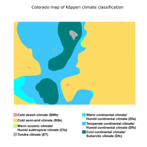
In mountainous areas like Colorado, the weather can change a lot over short distances. This is because of "microclimates," which are small areas with different weather patterns. The shape of the land, especially mountains, strongly affects the weather.
For example, near Denver, a special weather pattern called the Denver Cyclone can happen. The Rocky Mountains also influence weather far away, creating systems like the "Colorado low" that can bring storms.
Exploring Colorado's Regions
Colorado can be divided into several unique geographic regions. Each area has its own special features and landscape.
Eastern Plains: Wide Open Spaces
To the east of the Rocky Mountains are the Colorado Eastern Plains. These are part of the larger Great Plains region. Here, the land is mostly flat and ranges from about 1,067 to 2,134 meters (3,500 to 7,000 feet) high. The states of Kansas and Nebraska border Colorado to the east.
The plains are not very crowded. Most people live near the South Platte and Arkansas rivers. It doesn't rain much here, only about 380 millimeters (15 inches) each year. Farmers use some land for crops with irrigation, but much of it is used for "dryland farming" (without extra water) or for raising animals on ranches. Winter wheat is a common crop. Many small towns on the plains have both a water tower and a grain elevator.
Front Range: Where Most People Live
Most of Colorado's population lives along the eastern edge of the Rocky Mountains. This area is called the Front Range Urban Corridor. The tall mountains to the west help protect this region from strong storms.
Eastern Rocky Mountains: Tall Peaks and Forests
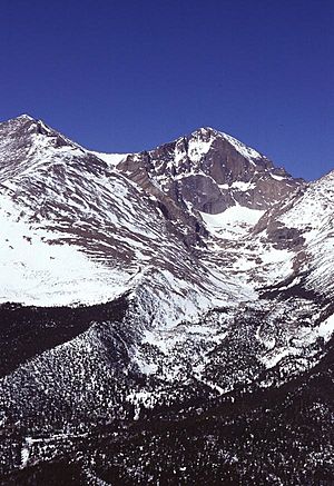
To the west of the Front Range are the eastern slopes of the Rocky Mountains. Here you'll find famous peaks like Longs Peak, Mount Blue Sky, Pikes Peak, and the Spanish Peaks. Water from this area flows east. The mountains are covered in forests and some cities. In 2002, a drought led to big forest fires in this area.
Continental Divide and Western Slope
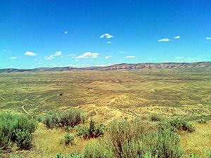
The Continental Divide is a line that runs along the top of the Rocky Mountains. It separates which ocean the water flows to. To the west of this divide is the Western Slope. All the water here flows west into the Pacific Ocean through the Colorado River. Western Colorado has mountains, mesas, desert canyons, and dry desert lands.
Interior Mountain Basins: High Valleys
Inside the Rocky Mountains, there are several large, flat areas called "parks" or basins.
- North Park is in the north, on the east side of the Continental Divide. The North Platte River flows out of it and goes north into Wyoming.
- Just south of North Park, but on the west side of the divide, is Middle Park. The Colorado River starts here.
- South Park is where the South Platte River begins.
- To the south is the San Luis Valley, where the Rio Grande river starts. This river flows south into New Mexico.
- Across the Sangre de Cristo Range from the San Luis Valley is the Wet Mountain Valley. These valleys are part of a major crack in the Earth's crust called the Rio Grande Rift.
Fourteeners and Mining History
The Rocky Mountains in Colorado are home to 54 peaks that are 4,267 meters (14,000 feet) or higher. These are known as "fourteeners." The mountains are covered with conifer trees and aspen trees up to the "tree line." This line is around 3,658 meters (12,000 feet) high in southern Colorado and about 3,200 meters (10,500 feet) in northern Colorado. Above the tree line, only small alpine plants can grow.
The Rockies are only covered in snow during the winter. Most of the snow melts by mid-August, except for a few small glaciers. The Colorado Mineral Belt stretches from the San Juan Mountains in the southwest to Boulder and Central City. This area holds most of Colorado's historic gold and silver mining districts.
Western Slope Details
The Western Slope is mostly drained by the Colorado River and its smaller rivers. In the south, you'll find the very rugged San Juan Mountains. To the west of the San Juans is the Colorado Plateau, a high desert area that extends into nearby states.
Grand Junction is the biggest city on the Western Slope. East of Grand Junction is Grand Mesa, a large, flat-topped mountain in the desert. Further east are popular ski resort towns like Aspen, Vail, Crested Butte, and Steamboat Springs. The northwestern part of Colorado, near Utah and Wyoming, is mostly open land with few people.
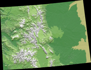
From west to east, Colorado's landscape changes dramatically. You go from desert basins, canyons, and mesas, to desert plateaus, then tall alpine mountains, and finally the grassy High Plains. Mount Elbert is the highest peak in the Rocky Mountains. The famous Pikes Peak is just west of Colorado Springs. On a clear day, you can see its lone peak from near the Kansas border!
Climate Information for Cities
| Climate data for Denver (DIA), 1981−2010 normals, extremes 1872−present | |||||||||||||
|---|---|---|---|---|---|---|---|---|---|---|---|---|---|
| Month | Jan | Feb | Mar | Apr | May | Jun | Jul | Aug | Sep | Oct | Nov | Dec | Year |
| Record high °F (°C) | 76 (24) |
80 (27) |
84 (29) |
90 (32) |
95 (35) |
105 (41) |
105 (41) |
105 (41) |
97 (36) |
90 (32) |
80 (27) |
79 (26) |
105 (41) |
| Mean maximum °F (°C) | 64.7 (18.2) |
66.5 (19.2) |
73.9 (23.3) |
80.8 (27.1) |
87.8 (31.0) |
95.9 (35.5) |
99.2 (37.3) |
96.4 (35.8) |
91.5 (33.1) |
82.7 (28.2) |
73.6 (23.1) |
64.9 (18.3) |
99.9 (37.7) |
| Mean daily maximum °F (°C) | 44.0 (6.7) |
46.2 (7.9) |
54.4 (12.4) |
61.5 (16.4) |
71.5 (21.9) |
82.4 (28.0) |
89.4 (31.9) |
87.2 (30.7) |
78.5 (25.8) |
65.3 (18.5) |
52.1 (11.2) |
42.8 (6.0) |
64.6 (18.1) |
| Daily mean °F (°C) | 30.7 (−0.7) |
32.5 (0.3) |
40.4 (4.7) |
47.4 (8.6) |
57.1 (13.9) |
64.7 (18.2) |
74.2 (23.4) |
72.5 (22.5) |
63.4 (17.4) |
50.9 (10.5) |
38.3 (3.5) |
30.0 (−1.1) |
50.5 (10.3) |
| Mean daily minimum °F (°C) | 17.4 (−8.1) |
18.9 (−7.3) |
26.4 (−3.1) |
33.3 (0.7) |
42.7 (5.9) |
52.3 (11.3) |
58.9 (14.9) |
57.9 (14.4) |
48.3 (9.1) |
36.6 (2.6) |
24.5 (−4.2) |
17.1 (−8.3) |
36.2 (2.3) |
| Mean minimum °F (°C) | −3 (−19) |
−1.3 (−18.5) |
10.4 (−12.0) |
19.7 (−6.8) |
31.0 (−0.6) |
41.6 (5.3) |
50.9 (10.5) |
49.9 (9.9) |
34.4 (1.3) |
21.5 (−5.8) |
5.5 (−14.7) |
−4.5 (−20.3) |
−12.7 (−24.8) |
| Record low °F (°C) | −29 (−34) |
−25 (−32) |
−11 (−24) |
−2 (−19) |
19 (−7) |
30 (−1) |
42 (6) |
40 (4) |
17 (−8) |
−2 (−19) |
−18 (−28) |
−25 (−32) |
−29 (−34) |
| Average precipitation inches (mm) | 0.41 (10) |
0.37 (9.4) |
0.92 (23) |
1.71 (43) |
2.12 (54) |
1.98 (50) |
2.16 (55) |
1.69 (43) |
0.96 (24) |
1.02 (26) |
0.61 (15) |
0.35 (8.9) |
14.30 (363) |
| Average snowfall inches (cm) | 7.0 (18) |
5.7 (14) |
10.7 (27) |
6.8 (17) |
1.1 (2.8) |
0 (0) |
0 (0) |
0 (0) |
1.3 (3.3) |
4.0 (10) |
8.7 (22) |
8.5 (22) |
53.8 (137) |
| Average precipitation days (≥ 0.01 in) | 4.1 | 5.3 | 5.9 | 9.1 | 9.4 | 8.4 | 8.3 | 8.6 | 6.5 | 5.3 | 4.7 | 4.1 | 79.7 |
| Average snowy days (≥ 0.1 in) | 5.0 | 5.3 | 5.8 | 4.1 | 0.6 | 0 | 0 | 0 | 0.5 | 1.8 | 4.9 | 5.3 | 33.3 |
| Average relative humidity (%) | 55.2 | 55.8 | 53.7 | 49.6 | 51.7 | 49.3 | 47.8 | 49.3 | 50.1 | 49.2 | 56.3 | 56.6 | 52.0 |
| Mean monthly sunshine hours | 215.3 | 211.1 | 255.6 | 276.2 | 290.0 | 315.3 | 325.0 | 306.4 | 272.3 | 249.2 | 194.3 | 195.9 | 3,106.6 |
| Percent possible sunshine | 72 | 70 | 69 | 69 | 65 | 70 | 71 | 72 | 73 | 72 | 65 | 67 | 70 |
| Source: NOAA (sun 1961−1990) | |||||||||||||
See also
 In Spanish: Geografía de Colorado para niños
 | Stephanie Wilson |
 | Charles Bolden |
 | Ronald McNair |
 | Frederick D. Gregory |


