
South Park (Park County, Colorado) facts for kids
Quick facts for kids South Park (Park County, Colorado) |
|
|---|---|

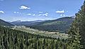
View of South Park along U.S. Highway 285 looking eastward toward the Front Range
|
|

Location in Colorado
|
|
| Floor elevation | 10,000 feet (3,000 m) |
| Area | 1,000 square miles (2,600 km2) |
| Geography | |
South Park is a large, flat grassland area in central Colorado. It's like a huge bowl surrounded by the Rocky Mountains, specifically the Mosquito and Park Mountain Ranges. This high valley sits at an elevation of about 9,000 to 10,000 feet (around 3,000 meters) above sea level.
It covers about 1,000 square miles (2,590 square kilometers) and is where the South Platte River begins. South Park is located in Park County, about 60 miles (100 kilometers) southwest of Denver. It's the biggest of three similar high-altitude areas in Colorado's Front Range. The other two are North Park and Middle Park. The largest town in South Park is Fairplay.
Contents
What is South Park?
South Park is a special type of landform called a "basin." A basin is like a giant dip or hollow in the Earth's surface. This one is surrounded by mountains. The flat, grassy areas are often called "flats" or "parks" in this region.
How South Park Was Formed
Rocks and Mountains
South Park is a wide valley made of layers of sedimentary rocks. These rocks were formed from bits of sand, mud, and ancient sea creatures that settled over millions of years. The valley sits between older, harder rocks of the Front Range to the east and the Sawatch Uplift to the west. The Mosquito Range forms a tall natural wall on the western side of the valley.
Long ago, there was a volcano called the Thirty-Nine Mile volcanic field to the southeast, but it's not active anymore.
Layers Under the Ground
Most of the valley floor is covered by a thin layer of gravel. This gravel was left behind by huge sheets of ice, called glaciers, during the Pleistocene Ice Age. Underneath this gravel are older sedimentary rocks.
A ridge called Red Hill runs through the middle of the valley. This ridge is made of tilted layers of rock from the Cretaceous and Jurassic periods.
Finding Valuable Minerals
Gold Mining History
People started looking for gold in South Park in 1859. They found a lot of gold in the streams, especially on the west side of the park. Gold was also mined from veins in the Mosquito Range. The large gravel ridges you can see east of Fairplay were created by machines that dug for gold.
Other Minerals
People have also looked for oil and natural gas in South Park, but they haven't found enough to make it worth mining. A small amount of uranium has also been found and mined from sandstone here.
Getting Around South Park

Several highways cross through South Park, making it easy to travel.
- U.S. Highway 285 comes into the valley from the east over Kenosha Pass. This road connects South Park to Denver. It also crosses Red Hill at Red Hill Pass.
- To the north, other mountain passes connect the valley to the North Fork of the South Platte River.
- Colorado Route 9 goes over Hoosier Pass to the Blue River valley, near Breckenridge.
- To the west, Mosquito Pass crosses the Mosquito Range to Leadville. This pass is very high and is now mainly used for history and recreation, not regular travel.
- To the southwest, Trout Creek Pass connects to the upper Arkansas River valley near Buena Vista.
- U.S. Highway 24 enters South Park from the east at Wilkerson Pass, connecting it to Colorado Springs.
- To the very south, Colorado Route 9 crosses Currant Creek Pass, which marks the southern edge of the South Park area.
A Look Back in Time
Native American History
Before European settlers arrived in the mid-1800s, the valley was home to the Utes. Later, in the 1850s, Southern Arapaho groups also started using the area. They loved it as a place to hunt buffalo, especially as their usual hunting grounds on the plains were changing. This sometimes led to disagreements and fights between the Utes and Arapaho over the land.
Explorers and Gold Rush
In 1844, an explorer named John C. Frémont explored the valley. He called it "Bayou Salade," which was a mixed-up version of the Spanish name "Valle Salado," meaning "salty valley."
In 1859, during the Colorado Gold Rush, people found gold in the streams of the valley. This brought many prospectors and miners to the area. The town of Fairplay was started around this time. It was seen as a more orderly place to live than the older, wilder town of Tarryall. Fairplay continued to be a center for gold and later silver mining until the mid-1900s.
Today, you can visit South Park City, an open-air museum near Fairplay. It shows what life was like during the gold rush days. In 1879, a railroad called the Denver, South Park and Pacific Railroad connected the basin to Denver, making travel and trade much easier.
South Park in Pop Culture
Since the late 1990s, South Park has become very well known as the setting for the popular animated series South Park. One of the show's creators, Trey Parker, grew up in Conifer, which is about 40 miles (65 kilometers) east of Fairplay.
Images for kids
-
A meadow near the headwaters of the Middle Fork South Platte River below Montgomery Reservoir in South Park

