Montgomery Reservoir facts for kids
Quick facts for kids Montgomery Reservoir |
|
|---|---|

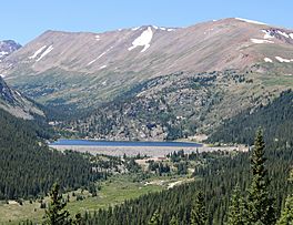
The reservoir and dam viewed from Highway 9
|
|
| Location | Park County, Colorado |
| Coordinates | 39°21′20″N 106°04′33″W / 39.35556°N 106.07583°W |
| Primary inflows | Middle Fork South Platte River Hoosier Tunnel |
| Primary outflows | Blue River Pipeline |
| Basin countries | United States |
| Managing agency | Water Resources Department, Colorado Springs Utilities |
| Built | 1957 |
| Surface area | 95 acres (38 hectares) |
| Water volume | 5,088 acre-feet (6,276,000 cubic metres) |
| Surface elevation | 10,873 feet (3,314 meters) |
| Frozen | in winter |
Montgomery Reservoir is a large lake high up in the mountains of Colorado. It's located in the Mosquito Range, close to Hoosier Pass and a few miles north of Alma, Colorado. This reservoir sits at a very high elevation of about 10,873 feet (3,314 meters) above sea level.
The reservoir was built in 1957. Its main purpose is to store water for the city of Colorado Springs, Colorado. The water is used by homes and businesses in the city.
Contents
How Montgomery Reservoir Gets Its Water
Montgomery Reservoir gets its water from two main places. One source is the Middle Fork South Platte River. The other, and most important, source is a special tunnel called the Hoosier Tunnel.
Water from the Hoosier Tunnel
The Hoosier Tunnel is very important for Montgomery Reservoir. It brings water from the Blue River watershed. This river is on the west side of the Continental Divide. The Continental Divide is like a giant ridge that separates rivers flowing to the Pacific Ocean from those flowing to the Atlantic Ocean.
Moving water from one side of the Continental Divide to the other is called a transbasin diversion. It means water is moved from one river basin to another. The Hoosier Tunnel helps move water from the Blue River basin (west side) to the Middle Fork South Platte River basin (east side).
Sending Water to Colorado Springs
Once the water is stored in Montgomery Reservoir, it travels a long way to Colorado Springs. It flows through a pipeline called the Blue River Pipeline. This pipeline is about 70-mile (110-kilometer) long.
The water travels by gravity through the pipeline. It ends up in two other reservoirs owned by Colorado Springs Utilities: North and South Catamount reservoirs. These are located on the slopes of Pikes Peak. From there, the water is cleaned and treated. After treatment, it's ready to be delivered to homes and businesses in Colorado Springs.
About the Dam
The Montgomery Dam holds back the water to create the reservoir. It's a type of dam called a rockfill structure. This means it's made mostly of rocks and earth.
The dam is quite large. It's about 1,900 feet (580 meters) long and 113 feet (34 meters) high. When it was built, the dam was sealed with a special layer of asphalt concrete. This layer helps make sure water doesn't leak through the dam.
 | Mary Eliza Mahoney |
 | Susie King Taylor |
 | Ida Gray |
 | Eliza Ann Grier |


