Blue River (Colorado) facts for kids
Quick facts for kids Blue River (Colorado) |
|
|---|---|

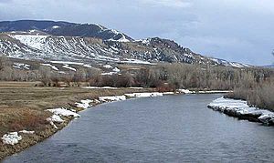
The Blue River near Kremmling, Colorado
|
|

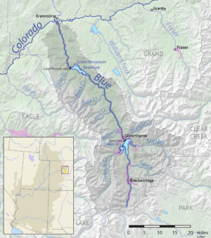
Map of the Blue River drainage basin
|
|
| Country | United States |
| State | Colorado |
| Physical characteristics | |
| Main source | Tenmile Range Near Blue River, Summit County 12,800 ft (3,900 m) 39°23′27″N 106°01′12″W / 39.39083°N 106.02000°W |
| River mouth | Colorado River Kremmling, Grand County 7,342 ft (2,238 m) 40°02′33″N 106°23′48″W / 40.04250°N 106.39667°W |
| Length | 65 mi (105 km) |
| Basin features | |
| Basin size | 680 sq mi (1,800 km2) |
| Tributaries |
|
The Blue River is a beautiful river in Colorado, United States. It is about 65 miles (105 km) long. This river is a key part of the larger Colorado River system. It helps provide water and power to many areas.
Exploring the Blue River
The Blue River starts in southern Summit County. This is on the western side of the continental divide. It begins in the Tenmile Range, close to Quandary Peak.
The River's Journey
The river flows north past the town of Blue River. It then goes through Breckenridge. After that, it reaches the Dillon Reservoir near Dillon.
The Dillon Reservoir is very important. It has a special tunnel called the "Roberts Tunnel." This tunnel was built in 1962 by Denver Water. It moves water from the Colorado River basin to the South Platte River Basin. This helps supply water to many people.
North of Dillon, the river continues flowing north-northwest. It runs along the eastern side of the Gore Range. Finally, the Blue River joins the Colorado River at Kremmling.
Green Mountain Dam and Reservoir
About 13 miles (21 km) upstream from Kremmling is the Green Mountain Dam. This dam creates the Green Mountain Reservoir. The reservoir is used to make hydroelectric power. This means it uses the force of water to create electricity.
The reservoir also provides water for irrigation. Irrigation is when water is supplied to help crops grow. The Green Mountain Dam is part of a bigger plan called the Colorado-Big Thompson Project. The United States Bureau of Reclamation built and manages this dam.
See also
 In Spanish: Río Azul (Colorado) para niños
 | Janet Taylor Pickett |
 | Synthia Saint James |
 | Howardena Pindell |
 | Faith Ringgold |

