
Dillon Reservoir facts for kids
Quick facts for kids Dillon Reservoir |
|
|---|---|

Dillon Reservoir in October
|
|

Dillon Reservoir
Location in Colorado

Dillon Reservoir
Location in the United States
|
|
| Location | Summit County, Colorado, United States |
| Coordinates | 39°36′27″N 106°03′18″W / 39.6074°N 106.0551°W |
| Type | Reservoir |
| Primary inflows | Blue River, Snake River |
| Primary outflows | Blue River |
| Basin countries | United States |
| Surface area | 3,233 acres (1,308 ha) |
| Water volume | 250,000 acre-feet (310,000,000 m3) |
| Shore length1 | 26.8 miles (43.1 km) |
| Surface elevation | 9,017 feet (2,748 m) |
| 1 Shore length is not a well-defined measure. | |
Dillon Reservoir, also known as Lake Dillon, is a large freshwater reservoir in Summit County, Colorado, United States. It is located south of I-70. The towns of Frisco, Silverthorne, and Dillon are all located around its edges.
This reservoir is very important for the city of Denver. Its water is managed by a company called Denver Water. Many popular ski resorts are also close to the reservoir. These include Copper Mountain, Keystone, Arapahoe Basin, and Breckenridge.
Contents
History of Dillon Reservoir
How the Town of Dillon Moved
In 1859, gold was found near the Blue River. This discovery brought many gold-seekers to Summit County, Colorado. By October 1859, about 100 miners were living along the river. By 1880, the population of Summit County grew to 5,459 people.
In 1881, the Dillon Mining Company started a town called Dillon. It was a trading post along the Snake River. The town of Dillon officially became a town in 1883. However, it soon had to move. The Denver and Rio Grande Railroad came to the area but bypassed Dillon. So, the town moved to the west bank of the Blue River.
Dillon moved a second time in 1892. This happened when the Denver, South Park and Pacific Railroad arrived. The town was then located where three rivers met: the Blue, Tenmile Creek, and the Snake. This allowed both railroad lines to have one station. In 1890, Dillon had 133 people. Before its third move in 1961, the town grew to 814 residents. Many of these people were construction workers for the new dam.
Building the Dam
The idea to build a dam on the Blue River came about in the early 1900s. The Denver Water Board bought most of the land for the reservoir. They got it for very low prices during the Great Depression. Many Dillon residents could not pay their property taxes then. The Denver Water Board already owned most of the water rights in the valley.
In 1956, Denver Water told the remaining residents they had to sell their homes. They needed to leave by September 15, 1961. Construction on the dam began in 1961 and finished in 1963. The dam is an earth-filled structure. It is 5,888 feet (1795 meters) long. It stands 231 feet (70 meters) tall above the Blue River.
The dam sends water from the Blue River Basin to Denver. It uses the 23.3-mile (37.5 km) Harold D. Roberts Tunnel. This tunnel goes under the Continental Divide. Tunneling started in 1942 and was completed in 1962. The tunnel is fully lined and is 10.25 feet (3.1 meters) wide inside. It can carry 1020 cubic feet of water per second (29 m³/sec). Each year, about 60,000 acre-feet (74 million m³) of water flow through it.
Moving the Town Again
The Denver Water Board set aside 172 acres for a new Town of Dillon. This new site was at the northeast edge of the future Dillon Reservoir. Residents and businesses had to pay to move their buildings. Many chose not to move them. However, the Dillon Community Church, Town Hall, and Arapaho Café and Motel were moved. They are still there today. The old church building is now a museum. It shows many old items from Dillon's history. Also, 327 graves were moved to a new cemetery.
Some buildings ended up in nearby towns. The Antler’s Café and Bar moved to Frisco. The Hamilton–Dillon Hotel moved to Breckenridge. The Mint Bar, Old Dillon Inn, Wildwood Bar, the post office, and a general store moved to what became Silverthorne. Most other old homes were torn down. Once the valley was clear, the reservoir was filled. After its third move, Dillon’s population dropped to just 57 people.
Fun Things to Do at Dillon Reservoir
Winter Activities
During ski season, many people visit the Dillon Reservoir area. The reservoir is close to four ski resorts. Arapahoe Basin is about ten miles from the lake. Keystone Ski Resort is a large tourist spot about five miles away. Breckenridge is one of Colorado's biggest ski resorts. It is about seven miles from Dillon Reservoir. Copper Mountain is about eight miles away. These resorts are open all year.
The reservoir is also a popular place itself. In winter, people enjoy ice fishing and snowmobiling.
Summer Activities
In warmer months, the towns of Dillon and Frisco have marinas on the reservoir. The Dillon Marina is open, and you can see hundreds of sailboats there. The Dillon Marina hosts many weekend regattas (boat races). You can also rent sailboats there. The Dillon Yacht Club is based at the Dillon Marina. It also hosts many sailing events. The Colorado Division of Wildlife stocks Dillon Reservoir every year. They add 50,000 rainbow trout for fishing.
Because Dillon Reservoir is near Dillon and Frisco, there are many places to stay. You can find lodging, camping, and RV sites.

Biking Around the Lake
Dillon Reservoir has a popular 18-mile paved bike path. It goes all the way around the reservoir. You can get on the path at any point. If you start in Frisco and go clockwise, it passes behind the Summit Middle School and marshlands. It then crosses the Dam road. The path goes past Silverthorne and Dillon.
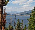
Once you are in the Summit Cove area, the path climbs over Swan Mountain. It reaches its highest point of 9,500 feet above sea level at Sapphire Point. This point is 1,100 feet higher than the lowest part of the path. Sapphire Point is a great spot to look out over Dillon Reservoir and Summit County. The path then turns into a road, so bikers and cars share it. The path starts again near Summit High School. It goes behind the hospital and back into Frisco.
Weather in Dillon
Dillon gets about 127 inches of snow each year. It usually snows from late September to mid-May. The area has nearly 300 sunny days a year. This helps keep the total snow amounts lower than the average rainfall. Some type of precipitation falls almost every day. July is usually the wettest month.
July is also the warmest month. The average high temperature is around 73 °F (23 °C). January is the coldest month. The average high is about 31 °F (−1 °C). The average low in July is 40 °F (4 °C). In January, the average low is 2 °F (−17 °C).
Geography of the Reservoir
Dillon Reservoir is at a maximum elevation of 9,017 feet (2,748 m) above sea level. It can hold about 257,304 acre-feet (320 million cubic meters) of water. Its shoreline is about 26.8 miles (43.1 km) long. The Dillon Dam is 5,888 feet (1,795 m) long and 231 feet (70 m) wide. The reservoir's average depth is 79 feet (24 m). Its water level is controlled. The area that drains into the reservoir is 330 square miles (850 km2). It also contains Silver Dollar Island.

Security of the Dam
The Dillon Dam Road has sometimes been closed for security reasons. This happened several times in 2008.
In January 2008, two men were filming a music video on the dam road. The road was already closed due to weather. The FBI investigated, as is normal for dam security. The men were found to have no bad intentions. The dam remained closed for a short time.
On July 8, 2008, Denver Water closed the dam road to most vehicles. Only emergency vehicles, walkers, and bikers were allowed. This caused a disagreement with Summit County. Denver Water had spent $10 million on security since September 11. But they still felt the dam was at risk, especially for Silverthorne, which is below the dam.
The dam road reopened on July 25. Denver Water put in strict rules. These included weight limits for vehicles. Security officers were placed at both ends of the dam all day. The road was closed from 10 p.m. to 6 a.m. Emergency vehicles could still use the road during closed hours by lowering steel barriers.
In 2011, the Dillon Dam Road was fully closed for several weeks. New security measures were added. These included new guard shacks, better lighting, and roundabouts. After this work finished in October, the road reopened 24 hours a day. Guards are now stationed at both ends around the clock.
How Water is Used
Dillon Reservoir is the largest water storage facility owned by Denver Water. The reservoir can hold 257,304 acre-feet (320 million cubic meters) of water. About 249,000 acre-feet (307,000,000 m3) of this water is "usable." This means it can be freely used without legal or physical limits. Denver Water serves over 1.3 million people. These customers use about 265,000 acre-feet (327,000,000 m3) of water each year.
Dillon Reservoir provides 40 percent of Denver Water's total supply. This is about 106,000 acre-feet (131,000,000 m3) of water. The reservoir usually has 92 percent of its usable water available each year.
One One acre-foot (1,230 m3; 326,000 US gal) of water can serve about 2.5 single-family homes for a year.
Dillon Reservoir is on the west side of the Continental Divide. The Harold D. Roberts Tunnel was finished in 1962. It brings water to Denver across the Divide. Most people in Colorado live on the eastern side of the state. Most water sources are on the western side. So, Colorado and Denver Water decided it was necessary to move water from west to east. This helps support the population.
Images for kids
-
Dillon Reservoir and Dillon Dam, with boaters in the summer, as seen from Sapphire Point

