Alma, Colorado facts for kids
Quick facts for kids
Alma, Colorado
|
|
|---|---|
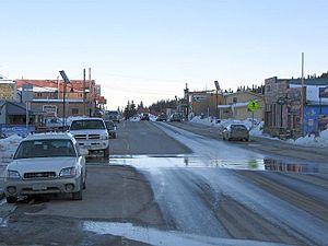
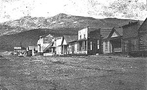
Main Street in Alma, March 2010
|
|
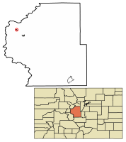
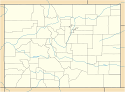
Location of the Town of Alma in Park County, Colorado.
|
|
| Country | |
| State | |
| County | Park |
| Incorporated | December 2, 1873 |
| Named for | Alma James |
| Government | |
| • Type | Statutory Town |
| Area | |
| • Statutory Town | 0.44 sq mi (1.13 km2) |
| • Land | 0.43 sq mi (1.12 km2) |
| • Water | 0.00 sq mi (0.01 km2) |
| Elevation | 10,361 ft (3,158 m) |
| Population
(2020)
|
|
| • Statutory Town | 296 |
| • Density | 682.03/sq mi (263.55/km2) |
| • Metro | 2,963,821 (19th) |
| • CSA | 3,623,560 (17th) |
| • Front Range | 5,055,344 |
| Time zone | UTC−07:00 (MST) |
| • Summer (DST) | UTC−06:00 (MDT) |
| ZIP code |
80420
|
| Area code(s) | 719 |
| FIPS code | 08-01530 |
| GNIS feature ID | 180003 |
| Highways | |
Alma is a small town in Park County, Colorado, United States. It is known for being a very high-altitude town. In 2020, about 296 people lived there. Alma is located west and south of the larger Denver-Aurora-Lakewood, CO Metropolitan Statistical Area.
Contents
About Alma, Colorado
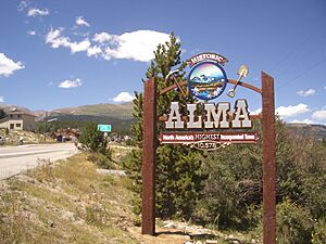
Alma is considered the highest incorporated town in the United States. This means it's the highest town with its own local government. It sits at an elevation of about 10,361 feet (3,158 meters) above sea level. Even its post office is the highest in the country!
It's important to know that Alma is a "town," not a "city." So, it doesn't take the title of "highest incorporated city" from Leadville, Colorado. There are also homes near Alma that are even higher. These homes use addresses from a nearby town called Fairplay, Colorado.
History of Alma
The town of Alma got its name from a merchant named Mr. James. He named it after his wife. Another story says it was named after a resident's daughter.
The first post office in Alma opened on March 7, 1873. The town officially became a town on December 2, 1873. Colorado became a state a few years later, on August 1, 1876.
Mining in Alma
Alma grew because of gold. Gold was first found in an area called Buckskin Gulch. As more mines opened on nearby mountains like Mount Bross and Mount Lincoln, more people moved to Alma. In the 1870s, Alma's population grew to about 10,000 people.
The area around Alma has many old mining sites. Most of these were placer mines, where miners looked for gold in riverbeds.
About two miles from Alma, you can find the remains of the old Orphan Boy mine. This mine opened in 1861 and produced gold, silver, lead, and zinc for many years.
Another famous mine near Alma is the historic Sweet Home Mine. It used to be a silver mine. Today, it is known for producing a beautiful pink mineral called rhodochrosite.
Geography and Climate
Alma is located right along State Highway 9. The town covers a total area of about 0.44 square miles (1.13 square kilometers). Only a tiny part of this is water.
Alma's Weather
Alma has a subalpine climate because it's so high up. This means the weather is like what you'd find in mountain areas.
- Summers: Summers are nice, with warm days and cool nights. July and August are the wettest months, often having thunderstorms.
- Spring and Autumn: These seasons are short but pleasant. Days are cool, and nights can get cold, sometimes freezing.
- Winters: Winters are cold and snowy. They usually last from late October to April. High temperatures are almost always below freezing. Lows can stay around zero degrees Fahrenheit for a third of the year. April often gets the most snowfall.
| Climate data for Alma | |||||||||||||
|---|---|---|---|---|---|---|---|---|---|---|---|---|---|
| Month | Jan | Feb | Mar | Apr | May | Jun | Jul | Aug | Sep | Oct | Nov | Dec | Year |
| Record high °F (°C) | 57 (14) |
57 (14) |
64 (18) |
66 (19) |
80 (27) |
86 (30) |
84 (29) |
83 (28) |
82 (28) |
72 (22) |
66 (19) |
56 (13) |
86 (30) |
| Mean daily maximum °F (°C) | 27.9 (−2.3) |
30.4 (−0.9) |
33.6 (0.9) |
41.2 (5.1) |
51.3 (10.7) |
62.2 (16.8) |
68.2 (20.1) |
65.7 (18.7) |
59.0 (15.0) |
49.1 (9.5) |
35.8 (2.1) |
28.6 (−1.9) |
46.1 (7.8) |
| Daily mean °F (°C) | 14.2 (−9.9) |
15.8 (−9.0) |
19.9 (−6.7) |
28.2 (−2.1) |
38.3 (3.5) |
47.8 (8.8) |
53.6 (12.0) |
51.6 (10.9) |
45.0 (7.2) |
35.6 (2.0) |
23.2 (−4.9) |
15.6 (−9.1) |
32.4 (0.2) |
| Mean daily minimum °F (°C) | 0.5 (−17.5) |
1.4 (−17.0) |
6.3 (−14.3) |
15.4 (−9.2) |
25.5 (−3.6) |
33.4 (0.8) |
39.2 (4.0) |
37.8 (3.2) |
30.9 (−0.6) |
22.3 (−5.4) |
10.8 (−11.8) |
2.8 (−16.2) |
18.9 (−7.3) |
| Record low °F (°C) | −35 (−37) |
−38 (−39) |
−30 (−34) |
−17 (−27) |
3 (−16) |
18 (−8) |
21 (−6) |
23 (−5) |
8 (−13) |
−8 (−22) |
−24 (−31) |
−31 (−35) |
−38 (−39) |
| Average precipitation inches (mm) | 1.46 (37) |
1.30 (33) |
1.73 (44) |
1.77 (45) |
1.65 (42) |
1.46 (37) |
2.40 (61) |
2.40 (61) |
1.58 (40) |
1.26 (32) |
1.42 (36) |
1.58 (40) |
20.01 (508) |
| Average snowfall inches (cm) | 17.0 (43) |
19.8 (50) |
22.0 (56) |
23.1 (59) |
9.2 (23) |
1.3 (3.3) |
0.1 (0.25) |
0 (0) |
2.0 (5.1) |
10.9 (28) |
21.5 (55) |
19.0 (48) |
145.9 (370.65) |
| Average snowy days | 9.5 | 8.7 | 10.4 | 9.2 | 4 | 0.6 | 0 | 0 | 0.9 | 3.9 | 8.4 | 8.9 | 64.5 |
Population of Alma
| Historical population | |||
|---|---|---|---|
| Census | Pop. | %± | |
| 1880 | 446 | — | |
| 1890 | 367 | −17.7% | |
| 1900 | 297 | −19.1% | |
| 1910 | 301 | 1.3% | |
| 1920 | 127 | −57.8% | |
| 1930 | 110 | −13.4% | |
| 1940 | 469 | 326.4% | |
| 1950 | 149 | −68.2% | |
| 1960 | 107 | −28.2% | |
| 1970 | 73 | −31.8% | |
| 1980 | 132 | 80.8% | |
| 1990 | 148 | 12.1% | |
| 2000 | 179 | 20.9% | |
| 2010 | 270 | 50.8% | |
| 2020 | 296 | 9.6% | |
| U.S. Decennial Census | |||
In 2000, there were 179 people living in Alma. These people lived in 94 households. About 18% of households had children under 18. Most people in Alma were White (92.74%). A small number were Native American, Asian, or from other backgrounds. About 3.35% of the population was Hispanic or Latino.
The average age of people in Alma was 37 years old. There were more males than females. The average income for a household was $41,563.
See also
 In Spanish: Alma (Colorado) para niños
 | Ernest Everett Just |
 | Mary Jackson |
 | Emmett Chappelle |
 | Marie Maynard Daly |


