
Fairplay, Colorado facts for kids
Quick facts for kids
Fairplay, Colorado
|
|
|---|---|

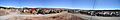
View of Fairplay and South Park looking south from State Highway 9. The historic buildings of South Park City, an open-air museum, are in the foreground.
|
|
| Nicknames:
The Real South Park
South Park City |
|
| Motto(s):
"Where History Meets the High Country"
|
|

Location of the Town of Fairplay in Park County, Colorado.
|
|

Fairplay, Colorado
Location in the United States
|
|
| Country | United States |
| State | Colorado |
| County | Park |
| Settled | 1859 |
| Incorporated | November 15, 1872 |
| Government | |
| • Type | Statutory town |
| Area | |
| • Total | 1.156 sq mi (2.995 km2) |
| • Land | 1.147 sq mi (2.971 km2) |
| • Water | 0.009 sq mi (0.024 km2) |
| Elevation | 9,948 ft (3,032 m) |
| Population
(2020)
|
|
| • Total | 724 |
| • Density | 631/sq mi (244/km2) |
| • Metro | 2,963,821 (19th) |
| • CSA | 3,623,560 (17th) |
| • Front Range | 5,055,344 |
| Time zone | UTC−07:00 (MST) |
| • Summer (DST) | UTC−06:00 (MDT) |
| ZIP code |
80440 & 80456, 80432 (PO Box)
|
| Area code(s) | 719 |
| FIPS code | 08-25610 |
| GNIS feature ID | 2412616 |
| Website | fairplayco.us |
Fairplay is a small town in Colorado, United States. It is the main town and county seat of Park County. In 2020, about 724 people lived there. Fairplay is known for being very high up, at an elevation of about 9,953 feet (3,034 meters). It is one of the highest towns in Colorado.
Contents
History of Fairplay
Fairplay started as a gold mining settlement in 1859. This was during the early days of the Pike's Peak Gold Rush. The town got its name because settlers wanted a "fair play" system. They were unhappy with how the first gold miners got very large claims. The town of Fairplay officially became a town in 1872.


Fairplay is the biggest community in a large grassland area called South Park. It sits where U.S. Highway 285 and State Highway 9 meet. The town is located on a hillside next to the Middle Fork South Platte River. Even though it started with gold mining, the area kept producing gold and silver for many years.
Today, Fairplay has modern shops along the highway. There is also a historic part of town along Front Street. This older area has been turned into an outdoor museum called South Park City. It shows what life was like during the Colorado Gold Rush. Most homes are on the hillside west of Highway 285. In 2005, most of the town's streets were paved.
Geography and Climate
Fairplay's Location
According to the 2020 United States Census, Fairplay covers about 1.16 square miles (2.995 square kilometers). A small part of this area, about 0.009 square miles (0.024 square kilometers), is water.
Weather in Fairplay
Fairplay has a subarctic or subalpine climate. This means it has short, cool summers. The winters are long, windy, and very cold. Because it is so high up, the air is dry and there are often clear skies. This causes big differences between day and night temperatures.
| Climate data for Fairplay Colorado, 1991–2020 normals, 2003-2019 snowfall: 9995ft (3046m) | |||||||||||||
|---|---|---|---|---|---|---|---|---|---|---|---|---|---|
| Month | Jan | Feb | Mar | Apr | May | Jun | Jul | Aug | Sep | Oct | Nov | Dec | Year |
| Record high °F (°C) | 55 (13) |
57 (14) |
60 (16) |
63 (17) |
74 (23) |
83 (28) |
84 (29) |
80 (27) |
77 (25) |
72 (22) |
62 (17) |
53 (12) |
84 (29) |
| Mean maximum °F (°C) | 47 (8) |
46 (8) |
53 (12) |
59 (15) |
68 (20) |
78 (26) |
80 (27) |
76 (24) |
73 (23) |
66 (19) |
55 (13) |
47 (8) |
84 (29) |
| Mean daily maximum °F (°C) | 30.8 (−0.7) |
30.9 (−0.6) |
38.1 (3.4) |
44.5 (6.9) |
54.5 (12.5) |
65.8 (18.8) |
71.0 (21.7) |
68.3 (20.2) |
62.1 (16.7) |
50.9 (10.5) |
39.1 (3.9) |
30.7 (−0.7) |
48.9 (9.4) |
| Daily mean °F (°C) | 20.2 (−6.6) |
20.1 (−6.6) |
26.9 (−2.8) |
33.2 (0.7) |
41.8 (5.4) |
51.2 (10.7) |
56.7 (13.7) |
54.6 (12.6) |
48.4 (9.1) |
38.4 (3.6) |
28.0 (−2.2) |
20.2 (−6.6) |
36.6 (2.6) |
| Mean daily minimum °F (°C) | 9.7 (−12.4) |
9.3 (−12.6) |
15.6 (−9.1) |
21.9 (−5.6) |
29.1 (−1.6) |
36.6 (2.6) |
42.4 (5.8) |
41.0 (5.0) |
34.7 (1.5) |
25.9 (−3.4) |
16.8 (−8.4) |
9.7 (−12.4) |
24.4 (−4.2) |
| Mean minimum °F (°C) | −7 (−22) |
−11 (−24) |
−2 (−19) |
8 (−13) |
15 (−9) |
29 (−2) |
37 (3) |
34 (1) |
26 (−3) |
9 (−13) |
−2 (−19) |
−11 (−24) |
−14 (−26) |
| Record low °F (°C) | −20 (−29) |
−28 (−33) |
−11 (−24) |
−5 (−21) |
2 (−17) |
23 (−5) |
33 (1) |
30 (−1) |
18 (−8) |
−14 (−26) |
−13 (−25) |
−19 (−28) |
−28 (−33) |
| Average precipitation inches (mm) | 0.65 (17) |
0.66 (17) |
1.10 (28) |
1.35 (34) |
1.78 (45) |
1.13 (29) |
2.40 (61) |
2.22 (56) |
1.44 (37) |
1.01 (26) |
0.63 (16) |
0.73 (19) |
15.1 (385) |
| Average snowfall inches (cm) | 7.9 (20) |
10.1 (26) |
13.4 (34) |
12.7 (32) |
8.2 (21) |
0.3 (0.76) |
trace | trace | 1.0 (2.5) |
6.9 (18) |
7.6 (19) |
11.9 (30) |
80 (203.26) |
| Source 1: NOAA | |||||||||||||
| Source 2: XMACIS (snowfall, records & monthly max/mins) | |||||||||||||
Population of Fairplay
| Historical population | |||
|---|---|---|---|
| Census | Pop. | %± | |
| 1890 | 301 | — | |
| 1900 | 319 | 6.0% | |
| 1910 | 265 | −16.9% | |
| 1920 | 183 | −30.9% | |
| 1930 | 221 | 20.8% | |
| 1940 | 739 | 234.4% | |
| 1950 | 476 | −35.6% | |
| 1960 | 404 | −15.1% | |
| 1970 | 419 | 3.7% | |
| 1980 | 421 | 0.5% | |
| 1990 | 387 | −8.1% | |
| 2000 | 610 | 57.6% | |
| 2010 | 679 | 11.3% | |
| 2020 | 724 | 6.6% | |
| U.S. Decennial Census | |||
In 2000, there were 610 people living in Fairplay. These people lived in 259 households. About 32% of these households had children under 18. The average household had 2.36 people. The median age in the town was 35 years old.
Arts and Culture in Fairplay

Burro Days Festival
The Burro Days festival is a special event held every year in Fairplay. It takes place on the last weekend of July. This festival celebrates the town's history of mining.
The main event is a long burro race.
- It is about 29 miles (46.7 km) long.
- The race goes over rough land and climbs about 3,000 feet (914 m).
- It starts in downtown Fairplay and ends at the top of Mosquito Pass.
- Each team has one person and one burro (a small donkey).
- The race usually takes about five hours to finish.
- The first prize is $1,000.
Fairplay's Burro Days is known as the World Championship of Burro Racing. It is also the longest burro race in Colorado. Long ago, in the 1960s and 1970s, the race sometimes went between Fairplay and Leadville. This route followed the path of Father John Lewis Dyer, who used to carry mail by burro.
Transportation in Fairplay
Fairplay is part of Colorado's Bustang bus system. This is an intercity bus network. Fairplay is a stop on the Gunnison-Denver Outrider line. This helps people travel to and from the town.
Notable People
- Sheldon Jackson was a Presbyterian missionary. He started what is now the South Park Community Presbyterian Church in Fairplay.
Images for kids
-
View of Fairplay and South Park.
See also
 In Spanish: Fairplay (Colorado) para niños
