
Park County, Colorado facts for kids
Quick facts for kids
Park County
|
|
|---|---|

Old Park County Courthouse
|
|

Location within the U.S. state of Colorado
|
|
 Colorado's location within the U.S. |
|
| Country | |
| State | |
| Founded | November 1, 1861 |
| Seat | Fairplay |
| Largest town | Fairplay |
| Area | |
| • Total | 2,211 sq mi (5,730 km2) |
| • Land | 2,194 sq mi (5,680 km2) |
| • Water | 17 sq mi (40 km2) 0.8%% |
| Population
(2020)
|
|
| • Total | 17,390 |
| • Estimate
(2023)
|
18,117 |
| • Density | 7.865/sq mi (3.0368/km2) |
| Time zone | UTC−7 (Mountain) |
| • Summer (DST) | UTC−6 (MDT) |
| Congressional district | 7th |
Park County is a county in the state of Colorado, USA. In 2020, about 17,390 people lived there. The main town, or county seat, is Fairplay. The county got its name from a big area called South Park. This name was given by early fur traders and trappers.
Park County is part of the larger Denver–Aurora–Lakewood area. Much of the county is also within the South Park National Heritage Area.
Contents
Geography of Park County
Park County is a large place! In 2020, it covered about 2,211 square miles. Most of this area, about 2,194 square miles, is land. The rest, about 17 square miles, is water.
Did you know the middle point of the entire state of Colorado is in Park County? It's a cool fact! Also, the South Platte River starts its journey right here in Park County.
Neighboring Counties
Park County shares its borders with several other counties:
- Clear Creek County to the north
- Jefferson County to the northeast
- Teller County to the east
- Fremont County to the southeast
- Chaffee County to the southwest
- Lake County to the west
- Summit County to the northwest
Main Roads
These are some of the important highways that go through Park County:
 U.S. Highway 24
 U.S. Highway 285
 State Highway 9
Protected Natural Areas
Park County is home to beautiful natural places. Some of these are protected to keep them wild and safe:
- Buffalo Peaks Wilderness
- Lost Creek Wilderness
- Pike National Forest
- San Isabel National Forest
State Parks and Areas
Colorado also protects special areas within the state:
- Eleven Mile State Park
- Spinney Mountain State Park
- Staunton State Park
Fun Trails and Scenic Drives
If you love exploring, Park County has many trails and scenic routes:
- American Discovery Trail
- Colorado Trail
- Continental Divide National Scenic Trail
- Great Parks Bicycle Route
- Guanella Pass Scenic Byway
- TransAmerica Trail Bicycle Route
People of Park County
| Historical population | |||
|---|---|---|---|
| Census | Pop. | %± | |
| 1870 | 447 | — | |
| 1880 | 3,970 | 788.1% | |
| 1890 | 3,548 | −10.6% | |
| 1900 | 2,998 | −15.5% | |
| 1910 | 2,492 | −16.9% | |
| 1920 | 1,977 | −20.7% | |
| 1930 | 2,052 | 3.8% | |
| 1940 | 3,272 | 59.5% | |
| 1950 | 1,870 | −42.8% | |
| 1960 | 1,822 | −2.6% | |
| 1970 | 2,185 | 19.9% | |
| 1980 | 5,333 | 144.1% | |
| 1990 | 7,174 | 34.5% | |
| 2000 | 14,523 | 102.4% | |
| 2010 | 16,206 | 11.6% | |
| 2020 | 17,390 | 7.3% | |
| 2023 (est.) | 18,117 | 11.8% | |
| U.S. Decennial Census 1790-1960 1900-1990 1990-2000 2010-2020 |
|||
In 2020, the population of Park County was 17,390 people. The county has grown a lot over the years. For example, in 1870, there were only 447 people living there!
Most people in Park County are White. There are also many people of Hispanic or Latino background. Other groups include Native American, Black or African American, and Asian people. Some people identify with two or more races.
There are about 7,688 homes in the county. Only a small part of the population, about 3.6%, is under 5 years old. The average age of people living in Park County is around 40 years old.
Towns and Communities
Park County has several towns and smaller communities.
Main Towns
Special Places (Census-designated)
These are areas that are like towns but not officially incorporated:
Other Small Communities
Ghost Towns
These are towns that were once active but are now mostly empty or abandoned:
- Antero Junction
- Buckskin Joe (also known as Laurette or Lauret)
- Garo
- Tarryall
- Trump
Famous People from Park County
- Gottlieb Fluhmann: He disappeared in 1892. His remains were found in a cave in Park County in 1944. How he died is still a mystery.
- Samuel Hartsel
- John J. Hoover
- Sheldon Jackson
Images for kids
-
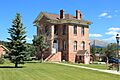
Old Park County Courthouse
See also
 In Spanish: Condado de Park (Colorado) para niños
