
Lakewood, Colorado facts for kids
Quick facts for kids
Lakewood, Colorado
|
||
|---|---|---|
.jpg)
Green Mountain as seen from Mt. Zion
|
||
|
||

Location of the City of Lakewood in Jefferson County, Colorado
|
||

Lakewood, Colorado
Location in Colorado

Lakewood, Colorado
Location in the United States
|
||
| Country | United States | |
| State | Colorado | |
| County | Jefferson County | |
| City | Lakewood | |
| Platted | July 1, 1889 | |
| Incorporated | June 24, 1969 | |
| Government | ||
| • Type | Home rule municipality | |
| Area | ||
| • Home rule municipality | 44.647 sq mi (115.635 km2) | |
| • Land | 43.473 sq mi (112.595 km2) | |
| • Water | 1.174 sq mi (3.040 km2) | |
| Elevation | 5,656 ft (1,724 m) | |
| Population
(2020)
|
||
| • Home rule municipality | 155,984 | |
| • Rank | 5th in Colorado 167th in the United States |
|
| • Density | 3,588/sq mi (1,385/km2) | |
| • Metro | 2,963,821 (19th) | |
| • CSA | 3,623,560 (17th) | |
| • Front Range | 5,055,344 | |
| Time zone | UTC−07:00 (MST) | |
| • Summer (DST) | UTC−06:00 (MDT) | |
| ZIP codes |
Denver 80214-80215, 80227, 80226-80228, 80232, 80235-80236
Golden 80401 Littleton 80123 |
|
| Area code(s) | Both 303 and 720 | |
| FIPS code | 08-43000 | |
| GNIS feature ID | 2411614 | |

Lakewood is a large city in Jefferson County, Colorado, United States. It is the most populated city in the county. In 2020, about 155,984 people lived there. This makes Lakewood the fifth largest city in Colorado. It is also the 167th largest city in the United States. Lakewood is a suburb of Denver. It is an important part of the larger Denver–Aurora–Lakewood, CO Metropolitan Statistical Area.
Contents
History of Lakewood
The area that is now Lakewood began to be developed in 1889. Two people, Charles Welch and William A.H. Loveland, planned out a 13-block area. This area was located along Colfax Avenue, west of Denver. Loveland, who used to be the president of the Colorado Central Railroad, moved to Lakewood after living in Golden for many years.
For a long time, until 1969, Lakewood did not have its own city government. Instead, different groups managed things like water and fire services. The Jefferson County Sheriff's office provided policing. Many neighborhoods did not even have street lights or sidewalks. Even without a city government, the community had been around for about 80 years.
The City of Lakewood officially became a city in 1969. It was first called Jefferson City. But soon after, people voted to change the name to Lakewood. They did not like "Jefferson City" and thought it might be confused with other places. When it became a city, over 90,000 people already lived there.
Lakewood never had a traditional downtown area like many older cities. West Colfax Avenue was a main road connecting Denver to the Rocky Mountains. This road became a busy area with many shops and businesses. Over time, larger shopping centers developed. One of these was the Villa Italia Mall. Later, the city decided to replace this mall with a new area called Belmar.
In 2011, Lakewood was recognized as an All-America City. This award celebrates communities that work together to solve problems.
Important Event in 2021
In December 2021, a serious incident occurred in Lakewood. A Lakewood Police Agent was injured while bravely stopping a dangerous person.
Geography and Nature
Lakewood is located in central Colorado. It is just west of Denver. The city sits where U.S. Route 6 and Colorado State Highway 121 meet. It is about 62 miles (100 km) north-northwest of Colorado Springs.
The city is in an area called the Colorado Piedmont. This is on the western edge of the Great Plains. It is also just east of the Front Range of the southern Rocky Mountains. A large, flat-topped hill called Green Mountain is in the western part of the city. It is about 6,854 feet (2,089 meters) tall.
Lakewood is in the area where water flows into the South Platte River. Several small streams flow east through the city. These include Lakewood Gulch, Weir Gulch, and Bear Creek. Many small lakes and reservoirs are also found in Lakewood. Some of these are Soda Lakes, Bear Creek Lake, and Kendrick Lake.
In 2020, Lakewood covered a total area of about 44.6 square miles (115.6 square kilometers). About 1.2 square miles (3.0 square kilometers) of this area is water.
Lakewood is a suburb of Denver. It is part of the larger Denver metropolitan area. It borders several other communities. These include Wheat Ridge to the north and Denver to the east.
Climate and Weather
Lakewood has a cold semi-arid climate. This means it is generally dry and has cold winters.
| Climate data for Lakewood, Colorado, 1991–2020 normals, extremes 1962–present | |||||||||||||
|---|---|---|---|---|---|---|---|---|---|---|---|---|---|
| Month | Jan | Feb | Mar | Apr | May | Jun | Jul | Aug | Sep | Oct | Nov | Dec | Year |
| Record high °F (°C) | 74 (23) |
77 (25) |
84 (29) |
86 (30) |
94 (34) |
104 (40) |
103 (39) |
101 (38) |
96 (36) |
89 (32) |
82 (28) |
75 (24) |
104 (40) |
| Mean maximum °F (°C) | 65.9 (18.8) |
65.6 (18.7) |
74.0 (23.3) |
78.4 (25.8) |
86.6 (30.3) |
94.9 (34.9) |
97.5 (36.4) |
95.0 (35.0) |
91.2 (32.9) |
82.4 (28.0) |
73.1 (22.8) |
65.2 (18.4) |
98.6 (37.0) |
| Mean daily maximum °F (°C) | 44.8 (7.1) |
45.3 (7.4) |
53.4 (11.9) |
59.0 (15.0) |
67.9 (19.9) |
79.8 (26.6) |
85.9 (29.9) |
83.7 (28.7) |
76.2 (24.6) |
63.4 (17.4) |
52.1 (11.2) |
44.6 (7.0) |
63.0 (17.2) |
| Daily mean °F (°C) | 32.9 (0.5) |
33.5 (0.8) |
41.0 (5.0) |
47.2 (8.4) |
56.0 (13.3) |
66.7 (19.3) |
72.8 (22.7) |
70.6 (21.4) |
62.4 (16.9) |
50.0 (10.0) |
40.0 (4.4) |
32.3 (0.2) |
50.4 (10.2) |
| Mean daily minimum °F (°C) | 21.1 (−6.1) |
21.6 (−5.8) |
28.6 (−1.9) |
35.3 (1.8) |
44.1 (6.7) |
53.5 (11.9) |
59.6 (15.3) |
57.5 (14.2) |
48.6 (9.2) |
36.6 (2.6) |
27.8 (−2.3) |
20.0 (−6.7) |
37.9 (3.2) |
| Mean minimum °F (°C) | 0.3 (−17.6) |
1.1 (−17.2) |
11.0 (−11.7) |
19.7 (−6.8) |
29.6 (−1.3) |
41.5 (5.3) |
50.6 (10.3) |
47.8 (8.8) |
34.6 (1.4) |
19.3 (−7.1) |
7.6 (−13.6) |
−0.3 (−17.9) |
−6.8 (−21.6) |
| Record low °F (°C) | −26 (−32) |
−23 (−31) |
−11 (−24) |
−1 (−18) |
19 (−7) |
27 (−3) |
37 (3) |
40 (4) |
16 (−9) |
5 (−15) |
−7 (−22) |
−25 (−32) |
−26 (−32) |
| Average precipitation inches (mm) | 0.64 (16) |
0.77 (20) |
1.33 (34) |
2.36 (60) |
2.62 (67) |
2.06 (52) |
2.00 (51) |
1.89 (48) |
1.38 (35) |
1.14 (29) |
0.82 (21) |
0.53 (13) |
17.54 (446) |
| Average snowfall inches (cm) | 8.0 (20) |
8.6 (22) |
9.2 (23) |
9.1 (23) |
1.7 (4.3) |
0.0 (0.0) |
0.0 (0.0) |
0.0 (0.0) |
0.3 (0.76) |
5.2 (13) |
9.2 (23) |
6.7 (17) |
58.0 (147) |
| Average precipitation days (≥ 0.01 in) | 4.5 | 4.9 | 5.6 | 7.2 | 10.3 | 8.4 | 9.4 | 9.7 | 7.2 | 5.7 | 4.4 | 3.9 | 81.2 |
| Average snowy days (≥ 0.1 in) | 3.6 | 4.2 | 3.7 | 2.4 | 0.6 | 0.0 | 0.0 | 0.0 | 0.1 | 1.3 | 2.6 | 3.2 | 21.7 |
| Source 1: NOAA | |||||||||||||
| Source 2: National Weather Service | |||||||||||||
People and Population
| Historical population | |||
|---|---|---|---|
| Census | Pop. | %± | |
| 1960 | 19,338 | — | |
| 1970 | 92,743 | 379.6% | |
| 1980 | 113,808 | 22.7% | |
| 1990 | 126,481 | 11.1% | |
| 2000 | 144,126 | 14.0% | |
| 2010 | 142,980 | −0.8% | |
| 2020 | 155,984 | 9.1% | |
| U.S. Decennial Census | |||
Lakewood is a diverse city with people from many backgrounds.
Population Data from 2020
| Race / Ethnicity (NH = Non-Hispanic) | Pop 2000 | Pop 2010 | Pop 2020 | % 2000 | % 2010 | % 2020 |
|---|---|---|---|---|---|---|
| White alone (NH) | 113,755 | 101,504 | 103,355 | 78.93% | 70.99% | 66.26% |
| Black or African American alone (NH) | 1,910 | 1,924 | 2,733 | 1.33% | 1.35% | 1.75% |
| Native American or Alaska Native alone (NH) | 1,085 | 987 | 1,106 | 0.75% | 0.69% | 0.71% |
| Asian alone (NH) | 3,854 | 4,347 | 5,798 | 2.67% | 3.04% | 3.72% |
| Pacific Islander alone (NH) | 112 | 144 | 212 | 0.08% | 0.10% | 0.14% |
| Some Other Race alone (NH) | 175 | 205 | 799 | 0.12% | 0.14% | 0.51% |
| Mixed Race or Multi-Racial (NH) | 2,286 | 2,402 | 6,558 | 1.59% | 1.68% | 4.20% |
| Hispanic or Latino (any race) | 20,949 | 31,467 | 35,423 | 14.54% | 22.01% | 22.71% |
| Total | 144,126 | 142,980 | 155,984 | 100.00% | 100.00% | 100.00% |
Population Data from 2010
In 2010, about 142,980 people lived in Lakewood. There were 61,986 households. About 26.8% of these households had children under 18. Many households were married couples living together.
The average household had 2.27 people. The average family had 2.92 people. About 20.8% of the population was under 18 years old. The median age was 39.2 years. This means half the people were younger and half were older than 39.2.
The median income for a household was $52,960. For families, it was $66,947. About 11.7% of the population lived below the poverty line. This included 20.3% of children under 18.
Economy and Jobs
Lakewood has a varied economy. The government is one of the biggest employers. Some companies based in Lakewood include Einstein Bros. Bagels and FirstBank.
In 2013, most people over 16 were working or looking for jobs. Many jobs were in management, business, and science. Other common jobs were in sales and office work. The top industries were education, healthcare, and retail.
The cost of living in Lakewood is a little higher than the average for the U.S. In 2013, the average home value was $238,500.
Major Employers in Lakewood
Here are the top employers in Lakewood based on their number of employees in 2023:
| Rank | Employer | Number of employees |
|---|---|---|
| 1 | Denver Federal Center | 8,000 |
| 2 | Jefferson County School District R-1 | 3,700 |
| 3 | State of Colorado | 2,610 |
| 4 | St. Anthony Hospital | 1,774 |
| 5 | Terumo BCT | 1,709 |
| 6 | FirstBank | 1,569 |
| 7 | City of Lakewood | 1,438 |
| 8 | Red Rocks Community College | 961 |
| 9 | Encore Electric | 892 |
| 10 | Colorado Christian University | 725 |
Education in Lakewood

Lakewood is part of the Jefferson County School District R-1.
The city has several high schools. These include Lakewood High School and Green Mountain High School. There are also schools like Bear Creek High School and Alameda International High School. Some schools offer the International Baccalaureate program. The private school Colorado Academy is also in Lakewood.
Lakewood is home to several colleges. You can find Colorado Christian University and Rocky Mountain College of Art and Design here. Red Rocks Community College also has a campus in Lakewood.
The Jefferson County Public Library serves the town.
Transportation and Travel
Highways and Roads
Nine main highways pass through Lakewood:
 Interstate 70 goes from east to west. It connects Lakewood to places like Utah and Maryland.
 US 6 (6th Avenue Freeway) also runs east-west within the city.
 US 40 (West Colfax Avenue) enters Lakewood from Denver. It continues west.
 US 285 connects to Lakewood from Denver. It runs along the southern edge of the city.
 State Highway 8 (Morrison Road) starts in Lakewood. It then goes west to Morrison.
 State Highway 95 (South Sheridan Boulevard) forms much of Lakewood's eastern border with Denver.
 State Highway 121 (South Wadsworth Boulevard) comes from Wheat Ridge in the north. It goes south into Denver.
 State Highway 391 (South Kipling Street) begins in Lakewood. It continues north into Wheat Ridge.
 State Highway 470 runs along the western side of the city.
Public Transportation
Bus and light rail services are available in Lakewood. The Regional Transportation District provides these services. They connect Lakewood to other parts of the Denver area. Light rail service started in Lakewood on April 26, 2013. This was with the opening of the W Line. There are seven light rail stations in the city. All of them are on the W Line.
For travel between cities, Bustang provides service. The Federal Center station in Lakewood is on Bustang's West Line. This line connects Denver to Grand Junction.
Places to Visit
Lakewood has many interesting places and historical sites:
- Belmar is the city's downtown area. It has shops, homes, and public spaces.
- The Colorado Campus of the Ohio Center for Broadcasting is located in Belmar. This is a school for radio and television.
- Belmar also has an Arts District. Here you can find artist studios and art galleries.
- Lakewood Cultural Center has a theater, art gallery, and art classrooms.
- Heritage Lakewood Belmar Park is a museum about the 20th century. It has historic buildings and hosts festivals. It is near Kountze Lake.
- William Fredrick Hayden Park is in the foothills of Green Mountain. The Colorado National Guard used to practice artillery here. Now, efforts are being made to find and remove any old unexploded items.
- The 40 West Arts District offers a bike and walking art path. It runs along the light rail line.
Famous People from Lakewood
Many notable people were born or have lived in Lakewood:
- Norma Anderson, a state legislator.
- Chris Broderick, a guitarist for the band Megadeth.
- Sol Katz, a pioneer in geospatial software.
- Tim Samaras, an engineer and storm chaser.
- May Bonfils Stanton, a Colorado heiress and giver of money to good causes.
- Steve Williams, a professional wrestler known as "Dr. Death."
Sister Cities
Lakewood has four sister cities. These are cities that have special friendly ties:
 Chester, Cheshire, United Kingdom
- Portsmouth, Hampshire, United Kingdom (also a Friendship City)
 Stade, Lower Saxony, Germany
 Sutherland Shire, Sydney, New South Wales, Australia
Images for kids
-
The official flag of Lakewood, Colorado.
-
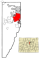
Map showing Lakewood's location in Jefferson County, Colorado.
-
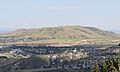
Green Mountain, a prominent landmark in Lakewood.
See also
 In Spanish: Lakewood (Colorado) para niños
