Wheat Ridge, Colorado facts for kids
Quick facts for kids
Wheat Ridge, Colorado
|
|||||
|---|---|---|---|---|---|
| City of Wheat Ridge | |||||

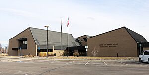
Wheat Ridge Municipal Building
|
|||||
|
|||||

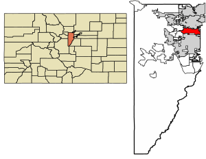
Location of the City of Wheat Ridge in Jefferson County, Colorado.
|
|||||
| Country | |||||
| State | |||||
| County | Jefferson County | ||||
| City | Wheat Ridge | ||||
| Incorporated | June 17, 1969 | ||||
| Area | |||||
| • Total | 9.58 sq mi (24.8 km2) | ||||
| • Land | 9.34 sq mi (24.2 km2) | ||||
| • Water | 0.24 sq mi (0.6 km2) | ||||
| Elevation | 5,459 ft (1,664 m) | ||||
| Population
(2020)
|
|||||
| • Total | 32,398 | ||||
| • Density | 3,381.8/sq mi (1,305.7/km2) | ||||
| Time zone | UTC−7 (MST) | ||||
| • Summer (DST) | UTC−6 (MDT) | ||||
| ZIP codes |
80212, 80214, 80215, 80033, 80034
|
||||
| Area code(s) | 303, 720 | ||||
| FIPS code | 08-84440 | ||||
| GNIS feature ID | 202840 | ||||
| Interstate highway | |||||
| State highways | |||||
| Commuter rail | G | ||||
The City of Wheat Ridge is a city in Jefferson County, Colorado, United States. It is located just west of Denver. Wheat Ridge is part of the larger Denver–Aurora–Lakewood, CO Metropolitan Statistical Area. The city's main building, the Wheat Ridge Municipal Center, is about 5 miles (8 km) west-northwest of the Colorado State Capitol in Denver. In 2020, about 32,398 people lived in Wheat Ridge.
Contents
The Story of Wheat Ridge
Wheat Ridge is a fairly new city, but it has a long history. It started as a popular rest stop for people traveling during the Gold Rush in the late 1850s.
Over time, it became a farming community. It was even known as the "Carnation City" in the mid-1900s because of all the carnations grown there. As more people moved to the area in the 1950s, new neighborhoods and businesses grew.
Many services like water and fire protection were created. Finally, to protect itself from nearby cities growing too big, Wheat Ridge officially became a city on June 17, 1969.
Where is Wheat Ridge?
Wheat Ridge is in central Colorado. It sits where Interstate 70 and Colorado State Highway 391 meet. The city is right next to Denver and about 66 miles (106 km) north-northwest of Colorado Springs.

The city is on the western edge of the Great Plains, just east of the Front Range of the Southern Rocky Mountains. A river called Clear Creek flows through the city. Lena Gulch, a smaller stream, also flows through the southwest part of the city.
Wheat Ridge has several small lakes. These include Crown Hill Lake, Kestrel Pond, and North Henry Lee Reservoir in the south-central area. West Lake, Tabor Lake, and Prospect Lake are located along Clear Creek in the west-central part of the city.
The city covers about 9.55 square miles (24.7 km2). Most of this area, about 9.30 square miles (24.1 km2), is land. The rest, about 0.25 square miles (0.65 km2), is water.
Wheat Ridge is a suburb of Denver. It shares borders with several other communities:
- Arvada to the north
- Lakeside, Mountain View, and Denver to the east
- Edgewater to the southeast
- Lakewood to the south
- Applewood to the southwest
- Fairmount to the northwest
What is the Weather Like?
Wheat Ridge has a climate called "Humid Continental." This means it has four distinct seasons. Summers are warm, and winters are cold with snow.
| Climate data for Wheat Ridge, Colorado, 1991–2020 normals, extremes 1981–present | |||||||||||||
|---|---|---|---|---|---|---|---|---|---|---|---|---|---|
| Month | Jan | Feb | Mar | Apr | May | Jun | Jul | Aug | Sep | Oct | Nov | Dec | Year |
| Record high °F (°C) | 78 (26) |
79 (26) |
84 (29) |
92 (33) |
97 (36) |
103 (39) |
103 (39) |
102 (39) |
100 (38) |
94 (34) |
84 (29) |
75 (24) |
103 (39) |
| Mean maximum °F (°C) | 68.8 (20.4) |
69.3 (20.7) |
76.4 (24.7) |
81.5 (27.5) |
88.4 (31.3) |
95.6 (35.3) |
98.3 (36.8) |
95.8 (35.4) |
92.7 (33.7) |
85.2 (29.6) |
75.0 (23.9) |
68.1 (20.1) |
98.6 (37.0) |
| Mean daily maximum °F (°C) | 47.2 (8.4) |
48.3 (9.1) |
56.6 (13.7) |
61.9 (16.6) |
70.9 (21.6) |
82.5 (28.1) |
88.2 (31.2) |
86.3 (30.2) |
79.0 (26.1) |
66.0 (18.9) |
54.8 (12.7) |
46.6 (8.1) |
65.7 (18.7) |
| Daily mean °F (°C) | 32.2 (0.1) |
33.3 (0.7) |
41.2 (5.1) |
47.5 (8.6) |
56.7 (13.7) |
66.8 (19.3) |
72.5 (22.5) |
70.4 (21.3) |
62.1 (16.7) |
49.8 (9.9) |
39.4 (4.1) |
31.6 (−0.2) |
50.3 (10.2) |
| Mean daily minimum °F (°C) | 17.1 (−8.3) |
18.3 (−7.6) |
25.9 (−3.4) |
33.0 (0.6) |
42.5 (5.8) |
51.1 (10.6) |
56.8 (13.8) |
54.5 (12.5) |
45.2 (7.3) |
33.6 (0.9) |
23.9 (−4.5) |
16.7 (−8.5) |
34.9 (1.6) |
| Mean minimum °F (°C) | −1.0 (−18.3) |
1.4 (−17.0) |
10.4 (−12.0) |
19.5 (−6.9) |
29.4 (−1.4) |
40.9 (4.9) |
50.0 (10.0) |
46.7 (8.2) |
33.5 (0.8) |
19.0 (−7.2) |
7.8 (−13.4) |
−1.1 (−18.4) |
−6.7 (−21.5) |
| Record low °F (°C) | −21 (−29) |
−23 (−31) |
−8 (−22) |
4 (−16) |
19 (−7) |
33 (1) |
40 (4) |
37 (3) |
14 (−10) |
2 (−17) |
−8 (−22) |
−24 (−31) |
−24 (−31) |
| Average precipitation inches (mm) | 0.64 (16) |
0.78 (20) |
1.48 (38) |
2.31 (59) |
2.65 (67) |
1.67 (42) |
1.88 (48) |
1.60 (41) |
1.34 (34) |
1.22 (31) |
0.92 (23) |
0.62 (16) |
17.11 (435) |
| Average snowfall inches (cm) | 9.6 (24) |
11.9 (30) |
12.9 (33) |
12.1 (31) |
2.2 (5.6) |
0.0 (0.0) |
0.0 (0.0) |
0.0 (0.0) |
1.0 (2.5) |
5.9 (15) |
10.0 (25) |
9.9 (25) |
75.5 (191.1) |
| Average precipitation days (≥ 0.01 in) | 5.1 | 6.0 | 7.1 | 9.1 | 10.3 | 8.3 | 8.8 | 8.3 | 6.9 | 6.0 | 5.9 | 4.9 | 86.7 |
| Average snowy days (≥ 0.1 in) | 5.7 | 6.3 | 5.9 | 5.0 | 1.4 | 0.0 | 0.0 | 0.0 | 0.4 | 2.2 | 5.0 | 5.7 | 37.6 |
| Source 1: NOAA | |||||||||||||
| Source 2: National Weather Service | |||||||||||||
Who Lives in Wheat Ridge?
| Historical population | |||
|---|---|---|---|
| Census | Pop. | %± | |
| 1960 | 21,619 | — | |
| 1970 | 29,778 | 37.7% | |
| 1980 | 30,293 | 1.7% | |
| 1990 | 29,419 | −2.9% | |
| 2000 | 32,913 | 11.9% | |
| 2010 | 30,166 | −8.3% | |
| 2020 | 32,398 | 7.4% | |
| U.S. Decennial Census | |||
In 2010, there were 30,166 people living in Wheat Ridge. There were 13,976 households, which are groups of people living together. About 7,489 of these were families.
Most people in Wheat Ridge are White (85.6%). There are also people of Asian (1.6%), African American (1.2%), and American Indian (1.2%) backgrounds. About 20.9% of the population is Hispanic or Latino.
About 23.1% of households had children under 18. The average household had 2.12 people, and the average family had 2.81 people. The median age in the city was 43.7 years old.
How People Make a Living
In 2013, about 65.2% of people over 16 years old had jobs or were looking for jobs. Most of these jobs were in the civilian workforce.
Many people work in management, business, science, and arts (37.3%). Others work in sales and office jobs (26.2%) or service jobs (18.5%).
The top three industries for jobs were:
- Education, health care, and social help (21.4%)
- Professional, scientific, and management services (12.3%)
- Retail stores (12.1%)
The cost of living in Wheat Ridge is a bit higher than the average for the U.S. In 2013, the average home value was $237,500.
Farming in the City
Before the 1960s, Wheat Ridge was mostly a farming area. There were many orchards and fields with some homes and businesses mixed in.
Today, Wheat Ridge has grown a lot with more homes and businesses. But you can still see hints of its farming past. The city now allows "urban agriculture." This means people can grow and sell food, and even keep animals like bees and chickens in their homes.
In 2011, the city passed a rule (Ordinance 1491) to support urban farming. This rule made it easier for community gardens, farmers' markets, and produce stands to exist in different parts of the city.
- Urban Gardens: These are areas where individuals or groups grow food or flowers. They can be community gardens where plots are rented, market gardens where crops are sold, or community supported agriculture (CSA) where people buy shares of a farm's harvest. Urban gardens are allowed in all parts of the city, even in neighborhoods with homes.
- Farmers' Markets: These markets are allowed in most areas, but not usually in residential areas with single or two-family homes. You need a business license to run a farmers' market.
- Produce Stands: These are temporary stands that sell fresh farm products like vegetables, fruits, herbs, flowers, nuts, honey, and eggs. They can also sell things made from these products, like jams. Produce stands also need a business license. If they are on private property, they must follow rules for home businesses.
City Planning and Growth
Wheat Ridge has been working to improve its community. This includes helping people connect with each other and making the city a better place to live.
Envision Wheat Ridge Plan
In 2008, the city started updating its "Comprehensive Plan." This plan helps guide how the city will grow and develop in the future. They hired experts and formed a group of citizens to help.
In 2009, the City Council approved the Envision Wheat Ridge Comprehensive Plan. This plan helps the city make good decisions about its future.
Fun Places to Visit
Wheat Ridge has some interesting historical spots.
Historic Sites
The James H. Baugh House is a special place in Wheat Ridge. It is listed on the National Register of Historic Places. The house started as a log cabin in the 1860s and was later covered by a farmhouse around 1904.
The Baugh House is one of several old buildings in the Wheat Ridge Historic Park. The Wheat Ridge Historical Society helped restore the house, which was officially recognized as historic in 2012.
Famous People from Wheat Ridge
Many interesting people have lived in Wheat Ridge, including:
- Dean Reed: An actor and singer.
- Bill and Dorothy Harmsen: They founded the famous Jolly Rancher candy company.
- Matthew Dominick: A NASA astronaut.
- Linda Brenneman: A U.S. Olympic cyclist.
See also
 In Spanish: Wheat Ridge para niños
 | Claudette Colvin |
 | Myrlie Evers-Williams |
 | Alberta Odell Jones |


