
Clear Creek (Colorado) facts for kids
Quick facts for kids Clear Creek |
|
|---|---|

US 6 in Clear Creek Canyon west of Golden
|
|
| Physical characteristics | |
| Main source | Clear Creek County, Colorado 39°40′29″N 105°55′23″W / 39.67472°N 105.92306°W |
| River mouth | Confluence with South Platte 5,092 ft (1,552 m) 39°49′39″N 104°56′57″W / 39.82750°N 104.94917°W |
| Length | 66 mi (106 km) |
| Basin features | |
| Progression | South Platte—Platte— Missouri—Mississippi |
Clear Creek is a river in central Colorado, USA. It's about 66 miles (106 km) long. This creek flows through a deep canyon in the Rocky Mountains, west of Denver. It then reaches the town of Golden. Finally, Clear Creek joins the South Platte River in the Eastern Plains.
Clear Creek is a bit unusual. It's called a "creek" but a "river" (Fall River) flows into it. Usually, rivers are bigger than creeks.
Contents
Why is Clear Creek Famous?
,_1833-1880.jpg)
Clear Creek became very famous during the Pike's Peak Gold Rush in 1859. This was a time when many people rushed to Colorado to find gold. The creek was a major spot for early gold mining.
A famous mountain man named Jim Baker lived near the creek. He had a cabin there from 1873 until he passed away in 1898.
The path of Clear Creek was also important for transportation. The Colorado Central Railroad used this route. Later, U.S. Highway 6 and Interstate 70 were built along the creek. These roads help people travel up to the Continental Divide west of Denver.
Where Does Clear Creek Flow?

Clear Creek starts high up in the mountains. Its source is near Loveland Pass in the Front Range. This area is in western Clear Creek County.
The creek flows east through Clear Creek Canyon. Along its way, it passes several towns. These towns include Silver Plume, Georgetown, and Idaho Springs. All these towns began as mining camps during the 1859 gold rush. Many smaller creeks flow into Clear Creek from the mountains around it.

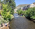
After leaving the canyon, the creek flows through Golden. It passes by the Coors brewery there. East of Golden, Clear Creek enters the Denver Metropolitan Area. It flows through parts of Lakewood and Wheat Ridge.
In this area, the creek is mostly an urban stream. There's a wooded park along part of the creek. This park has paths for bicycles and walking. Clear Creek then goes under Interstate 25. It finally joins the South Platte River in southeast Thornton.
What is the History of Clear Creek's Name?

Clear Creek had different names in the past. Around 1820, it was called Cannonball Creek. French hunters gave it this name because of the round rocks in its bed.
In the 1830s, it became known as Vasquez Fork or Vasquez River. This name came from a fur trader named Louis Vasquez. He had a fort near the mouth of the river. The name "Clear Creek" was given by the gold rushers in 1859.
Images for kids
-
Looking east from the Washington Avenue bridge in Golden

