
Loveland Pass facts for kids
Quick facts for kids Loveland Pass |
|
|---|---|

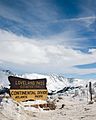
Loveland Pass in late March 2005
|
|
| Elevation | 11,990 ft (3,655 m) |
| Traversed by | |
| Location | Clear Creek / Summit counties, Colorado, U.S. |
| Range | Front Range |
| Coordinates | 39°39′49″N 105°52′45″W / 39.66361°N 105.87917°W |
| Topo map | USGS Loveland Pass |
Loveland Pass is a very high mountain pass in the Rocky Mountains of Colorado. It sits at an elevation of 11,990 feet (3,655 m) above sea level. This makes it one of the highest points you can drive over in the United States.
Contents
What is Loveland Pass?
.jpg)
Loveland Pass is located in north-central Colorado. It crosses the Continental Divide. This is an imaginary line where water on one side flows to the Pacific Ocean and water on the other side flows to the Atlantic Ocean. The pass is part of the Front Range mountains, west of Denver.
The pass is on U.S. Highway 6 (US 6). The road is known for being tricky, especially in winter. It has a steep 6.7% slope and many sharp turns. This makes it hard for snowplows to keep the road clear.
Who was Loveland Pass named after?
The pass is named after William A.H. Loveland. He was the president of the Colorado Central Railroad in the late 1800s. He lived in Golden. The city of Loveland in Larimer County is also named after him.
Loveland wanted a wagon road between Denver and Leadville. In 1869, he opened the section of road that became Loveland Pass. It was closed in 1906 but reopened for cars in 1920. The U.S. Forest Service helped restore it.
Why is Loveland Pass important for travel?
Loveland Pass is the highest mountain pass in Colorado that usually stays open all winter. In March 1973, the Eisenhower Tunnel opened. This tunnel allows most drivers on Interstate 70 (I-70) to avoid the pass.
However, some vehicles still use Loveland Pass. Trucks carrying dangerous materials or those taller than 13 feet 11 inches (4.24 m) cannot go through the tunnel. They must use US 6 over the pass. This route is about 800 vertical feet (240 m) higher than the tunnel. Also, bicyclists, walkers, and people who want to see the views still use the pass.
What activities can you do at Loveland Pass?
Loveland Ski Area is located north of the pass. Arapahoe Basin is to the south. The pass itself is a popular spot for backcountry skiing. This is skiing in undeveloped areas.
Sometimes in winter, blizzards can close the pass road. When this happens, all traffic, even hazardous material trucks, must use the tunnel. During smaller storms, drivers might need to use chains on their tires. At the Loveland Pass parking lot, visitors can find trails. These trails lead to mountain peaks like Mount Sniktau.
What is the climate like at Loveland Pass?
Loveland Pass has a cold climate, known as a subarctic climate. This means it has long, cold winters and short, cool summers. The Loveland Basin, near the pass summit, is part of the Loveland Ski Area.
| Climate data for Loveland Basin, Colorado, 1994–2020 normals: 11400ft (3475m) | |||||||||||||
|---|---|---|---|---|---|---|---|---|---|---|---|---|---|
| Month | Jan | Feb | Mar | Apr | May | Jun | Jul | Aug | Sep | Oct | Nov | Dec | Year |
| Mean daily maximum °F (°C) | 25.0 (−3.9) |
27.4 (−2.6) |
36.1 (2.3) |
42.2 (5.7) |
50.4 (10.2) |
59.5 (15.3) |
65.2 (18.4) |
62.6 (17.0) |
56.1 (13.4) |
44.1 (6.7) |
33.0 (0.6) |
24.3 (−4.3) |
43.8 (6.6) |
| Daily mean °F (°C) | 16.4 (−8.7) |
17.5 (−8.1) |
24.5 (−4.2) |
30.1 (−1.1) |
38.7 (3.7) |
47.6 (8.7) |
53.1 (11.7) |
51.2 (10.7) |
45.2 (7.3) |
34.3 (1.3) |
24.2 (−4.3) |
16.1 (−8.8) |
33.2 (0.7) |
| Mean daily minimum °F (°C) | 7.7 (−13.5) |
7.6 (−13.6) |
12.8 (−10.7) |
18.0 (−7.8) |
26.9 (−2.8) |
35.8 (2.1) |
41.1 (5.1) |
39.9 (4.4) |
34.2 (1.2) |
24.6 (−4.1) |
15.3 (−9.3) |
7.8 (−13.4) |
22.6 (−5.2) |
| Average precipitation inches (mm) | 3.06 (78) |
2.90 (74) |
3.24 (82) |
4.20 (107) |
3.16 (80) |
1.60 (41) |
2.46 (62) |
2.36 (60) |
2.11 (54) |
2.51 (64) |
2.90 (74) |
2.76 (70) |
33.26 (846) |
| Source 1: XMACIS2 | |||||||||||||
| Source 2: NOAA (Precipitation 1991-2020) | |||||||||||||
Notable Events at Loveland Pass

Loveland Pass has been the site of some serious events.
What happened with the plane crash near Loveland Pass?
In October 1970, a plane carrying the Wichita State University football team crashed near the pass. It happened about two miles (3.2 km) north of the summit. Sadly, many people on board did not survive. Investigators found that mistakes made by the pilot caused the crash.
Has there been an avalanche at Loveland Pass?
Yes, on April 20, 2013, a large avalanche occurred at Loveland Pass. This avalanche was very serious. It was the deadliest avalanche in Colorado since 1962. One snowboarder involved in the incident was rescued by a search and rescue team.
Images for kids
-
Loveland Pass in late March 2005
-
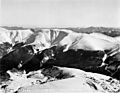
Loveland Pass, 1941
-
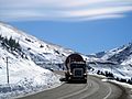
US 6 through Loveland Pass is the primary route for trucks that are prohibited from passing through the Eisenhower Tunnel.
