
Loveland, Colorado facts for kids
Quick facts for kids
Loveland, Colorado
|
||
|---|---|---|
 |
||
|
||
| Nickname(s):
The Sweetheart City
|
||

Location within Larimer County, Colorado
|
||

Loveland, Colorado
Location in the United States
|
||
| Country | United States | |
| State | Colorado | |
| County | Larimer County | |
| City | Loveland | |
| Founded | 1877 | |
| Incorporated | April 30, 1881 | |
| Named for | William A. H. Loveland | |
| Government | ||
| • Type | Home rule municipality | |
| Area | ||
| • Total | 35.88 sq mi (92.94 km2) | |
| • Land | 34.41 sq mi (89.11 km2) | |
| • Water | 1.48 sq mi (3.83 km2) 4.13% | |
| Elevation | 4,997 ft (1,523 m) | |
| Population
(2020)
|
||
| • Total | 76,378 | |
| • Density | 2,128.71/sq mi (821.80/km2) | |
| Time zone | UTC−7 (MST) | |
| • Summer (DST) | UTC−6 (MDT) | |
| ZIP Codes |
80534, 80537–80539
|
|
| Area code(s) | 970 | |
| FIPS code | 08-46465 | |
| GNIS feature ID | 2410886 | |
| Highways | I-25, US 34, US 287, SH 60, SH 402 | |

Loveland is a city in Larimer County, Colorado, United States. It is the second-biggest city in Larimer County. Loveland is about 46 miles (74 km) north of Denver, the capital of Colorado. It is also the 14th largest city in Colorado.
In 2020, about 76,378 people lived in Loveland. The city is part of a larger area called the Fort Collins-Loveland Metropolitan Statistical Area. The public schools in Loveland are part of the Thompson R2-J School District.
Contents
History of Loveland
The area where Loveland is now was once a busy place for French fur trappers in the late 1700s and early 1800s. The first settlement was built by Mariano Medina in 1858. It was called Fort Namaqua and served as a place for trading and a stop for stagecoaches. Today, this spot is Namaqua Park.
Loveland was officially started in 1877. It was built along the new Colorado Central Railroad line, close to where it crossed the Big Thompson River. The city was named after William A.H. Loveland, who was the president of the railroad. The town of Loveland was officially made a city on April 30, 1881.
For the first half of the 1900s, Loveland's economy depended on farming. Farmers grew mostly sugar beets and sour cherries. A sugar factory was built in 1901, providing many jobs until it closed in 1977. In the late 1920s, the Spring Glade Orchard was the biggest cherry orchard west of the Mississippi River.
Cherry farming eventually stopped because of dry weather, plant diseases, and competition from other states. By the late 1960s, cherries were no longer a major crop. Later in the 1900s, the city's economy changed. Companies like Hewlett-Packard and Teledyne opened factories there. A new medical center also created many jobs.
Floods in Loveland
Loveland has experienced major floods. On September 12, 2013, heavy rain fell for four days. This caused rivers and creeks to overflow. The Big Thompson River swelled, damaging parts of U.S. Highway 34, which connects Loveland to Estes Park.
This 2013 flood is often compared to the Big Thompson Flood of 1976. Both were very rare events, sometimes called "500-year floods." In 2013, two people died in Larimer County. In the 1976 flood, 144 people lost their lives.
Geography of Loveland
Loveland is located in the Colorado Front Range area. It sits at the base of the foothills, just east of the Big Thompson River Canyon. You can see Longs Peak and other mountains from many parts of the city.
Loveland is in the southeastern part of Larimer County. It is south of Fort Collins, which is a larger city and the county seat. The two cities have grown closer over time. The U.S. government considers them one metropolitan area.
The city has a total area of about 35.88 square miles (92.94 square kilometers). About 1.48 square miles (3.83 square kilometers) of this area is water.
It's interesting to know that Loveland Pass, a mountain pass also named after William A.H. Loveland, is not actually near the city of Loveland.
Climate in Loveland
Loveland has a climate with warm to hot summers and long, moderately cold winters. Sometimes, winters can be very cold. Because it doesn't get a lot of rain, Loveland's climate can also be described as cold semi-arid.
Loveland gets about 47 inches (119 cm) of snow each year. The hottest temperature ever recorded in Loveland was 106°F (41°C) on July 19, 2022. The coldest temperature was -31°F (-35°C) on December 22, 1990.
| Climate data for Loveland, Colorado, 1991–2020 normals, extremes 1989–present | |||||||||||||
|---|---|---|---|---|---|---|---|---|---|---|---|---|---|
| Month | Jan | Feb | Mar | Apr | May | Jun | Jul | Aug | Sep | Oct | Nov | Dec | Year |
| Record high °F (°C) | 74 (23) |
75 (24) |
83 (28) |
89 (32) |
98 (37) |
103 (39) |
106 (41) |
103 (39) |
103 (39) |
89 (32) |
81 (27) |
73 (23) |
106 (41) |
| Mean maximum °F (°C) | 63.3 (17.4) |
66.1 (18.9) |
75.9 (24.4) |
81.5 (27.5) |
88.8 (31.6) |
96.1 (35.6) |
98.6 (37.0) |
96.6 (35.9) |
93.1 (33.9) |
84.2 (29.0) |
73.8 (23.2) |
63.4 (17.4) |
99.5 (37.5) |
| Mean daily maximum °F (°C) | 43.9 (6.6) |
46.2 (7.9) |
56.1 (13.4) |
62.4 (16.9) |
71.0 (21.7) |
82.7 (28.2) |
88.6 (31.4) |
86.7 (30.4) |
78.9 (26.1) |
65.2 (18.4) |
52.8 (11.6) |
43.6 (6.4) |
64.8 (18.3) |
| Daily mean °F (°C) | 28.4 (−2.0) |
30.8 (−0.7) |
39.5 (4.2) |
46.5 (8.1) |
55.4 (13.0) |
66.0 (18.9) |
71.9 (22.2) |
69.8 (21.0) |
61.5 (16.4) |
48.7 (9.3) |
37.0 (2.8) |
28.5 (−1.9) |
48.7 (9.3) |
| Mean daily minimum °F (°C) | 12.9 (−10.6) |
15.4 (−9.2) |
23.0 (−5.0) |
30.6 (−0.8) |
39.8 (4.3) |
49.2 (9.6) |
55.1 (12.8) |
52.9 (11.6) |
44.2 (6.8) |
32.2 (0.1) |
21.1 (−6.1) |
13.4 (−10.3) |
32.5 (0.3) |
| Mean minimum °F (°C) | −7.3 (−21.8) |
−2.2 (−19.0) |
7.7 (−13.5) |
18.8 (−7.3) |
28.3 (−2.1) |
41.0 (5.0) |
49.7 (9.8) |
46.5 (8.1) |
33.1 (0.6) |
17.1 (−8.3) |
4.3 (−15.4) |
−5.4 (−20.8) |
−12.5 (−24.7) |
| Record low °F (°C) | −24 (−31) |
−22 (−30) |
−13 (−25) |
4 (−16) |
10 (−12) |
34 (1) |
42 (6) |
38 (3) |
25 (−4) |
−8 (−22) |
−15 (−26) |
−31 (−35) |
−31 (−35) |
| Average precipitation inches (mm) | 0.52 (13) |
0.62 (16) |
1.28 (33) |
2.18 (55) |
2.68 (68) |
1.63 (41) |
1.47 (37) |
1.29 (33) |
1.36 (35) |
1.18 (30) |
0.81 (21) |
0.58 (15) |
15.60 (396) |
| Average snowfall inches (cm) | 6.0 (15) |
8.2 (21) |
7.9 (20) |
5.7 (14) |
1.1 (2.8) |
0.0 (0.0) |
0.0 (0.0) |
0.0 (0.0) |
0.0 (0.0) |
3.5 (8.9) |
7.0 (18) |
7.6 (19) |
47.0 (119) |
| Average precipitation days (≥ 0.01 in) | 4.9 | 6.8 | 7.2 | 9.9 | 12.5 | 10.0 | 9.4 | 9.1 | 7.5 | 6.4 | 6.0 | 4.6 | 94.3 |
| Average snowy days (≥ 0.1 in) | 3.9 | 4.8 | 2.8 | 2.4 | 0.4 | 0.0 | 0.0 | 0.0 | 0.0 | 1.3 | 3.5 | 3.9 | 23.0 |
| Source 1: NOAA | |||||||||||||
| Source 2: National Weather Service | |||||||||||||
People in Loveland
| Historical population | |||
|---|---|---|---|
| Census | Pop. | %± | |
| 1880 | 236 | — | |
| 1890 | 698 | 195.8% | |
| 1900 | 1,091 | 56.3% | |
| 1910 | 3,651 | 234.6% | |
| 1920 | 5,065 | 38.7% | |
| 1930 | 5,506 | 8.7% | |
| 1940 | 6,145 | 11.6% | |
| 1950 | 6,773 | 10.2% | |
| 1960 | 9,734 | 43.7% | |
| 1970 | 16,220 | 66.6% | |
| 1980 | 30,215 | 86.3% | |
| 1990 | 37,352 | 23.6% | |
| 2000 | 50,608 | 35.5% | |
| 2010 | 66,859 | 32.1% | |
| 2020 | 76,378 | 14.2% | |
| U.S. Decennial Census 2020 | |||
In 2000, Loveland had 50,608 people. By 2020, the population grew to 76,378. This is a 51% increase!
Most people in Loveland are White. In 2020, about 84% of the population was White. About 13% of the people in Loveland are of Hispanic or Latino background.
In 2000, there were about 19,741 households in the city. Over a third of these households (35.3%) had children under 18 living there. Most households (57.5%) were married couples. The average household had about 2.55 people.
The median age in Loveland was 36 years old. This means half the people were younger than 36, and half were older.
Economy of Loveland
Loveland is located on U.S. Highway 34, which is a main road to Estes Park and Rocky Mountain National Park. This means many tourists pass through Loveland, especially in the summer.
The city is also a "bedroom community." This means many people who live in Loveland travel to nearby cities for work. They might commute to Boulder, Westminster, or the Denver area. Some also work in college towns like Fort Collins (home to CSU), Greeley (UNC), and Boulder (CU).
Loveland has been expanding its city limits eastward. This area, near Interstate 25 and U.S. Highway 34, is becoming a major business center for northern Colorado. New shopping centers, a medical center, and the Blue Arena have been built there. This area is called Centerra.
Loveland's Valentine Re-Mailing Program
Loveland is famous for its special Valentine Re-Mailing Program. For many years, people from all over the world send their valentines to Loveland. Here, volunteers hand-stamp the cards with a unique design and a special postal cancellation mark.
Each year, a new design and poem are chosen for the stamp through a contest. On average, this program re-mails over 160,000 cards from the United States and more than 110 other countries!
The program started in 1947. The postmaster, Elmer Ivers, received about 30 valentines from people who wanted them postmarked from Loveland for a "romantic extra touch." He and Ted Thompson realized this could be a great way to promote Loveland. The Loveland Chamber of Commerce agreed to help.
Ted Thompson designed the first stamp with the message, "A Valentine Greeting from Sweetheart Town, Loveland, Colorado." It showed a heart with an arrow over the Rocky Mountains. Since then, a different verse and design have been used every year.
Besides the mailing program, people can also pay to have large valentine messages placed on wooden hearts. These hearts are displayed on the streets of Loveland. Many of these public valentines are for marriage proposals, anniversaries, or yearly traditions.
Arts and Culture in Loveland

Loveland has many artists. Because of this, the city has three art foundries (places where sculptures are made), an art museum, and hosts annual sculpture shows in August.

The city of Loveland has a large collection of public art, with 475 pieces. Most of these are sculptures, but there are also murals and other artworks. Over 150 sculptures can be found in the beautiful Benson Sculpture Garden.
The Sculpture in the Park show is held every August. It features amazing artwork from artists from the United States and around the world.
Parks and Recreation
Lake Loveland is an important lake within the city. It was originally built to help with irrigation for farming. Today, it provides water for the city of Greeley.
While the city used to have a swimming beach on Lake Loveland, the rights for recreation now belong to the homeowners around the lake. However, you can still go fishing from the public areas along Southshore Parkway and North Lake Park.
Education in Loveland
Colleges and Universities
- Aims Community College
- Colorado Christian University (Northern Colorado Center satellite site)
High Schools
- Harold Ferguson High School
- Loveland High School
- Mountain View High School
- Thompson Valley High School
- Loveland Classical High School
Transportation in Loveland

The Fort Collins / Loveland Airport is used for private and general flights. It does not have commercial airline service. The closest airport with commercial flights is Denver International Airport, which is about 70 miles (113 km) south.
You can reach Loveland from Denver by car using Interstate 25. There are also shared shuttle services like Green Ride Colorado and Red Lion that offer rides to and from Denver International Airport.
U.S. Highway 34 runs east to west through Loveland. It is called Eisenhower Boulevard within the city and divides Loveland in half.
Loveland has its own city bus system called COLT, which stands for City of Loveland Transit. Loveland is also connected to other nearby towns like Fort Collins, Berthoud, and Longmont by the FLEX regional bus route. You can also take the Bustang express bus to Denver.
Notable People from Loveland
- Wayne Allard, a former U.S. Senator from Colorado
- Jeremy Bloom, an Olympic skier and former football player
- Molly Bloom, an author
- Jeff Byers, a football player for the Carolina Panthers
- Lindsey Daugherty, a member of the Colorado House of Representatives
- Alexi Grewal, an Olympic gold medal winning cyclist
- Meredith Hodges, an equine (horse) trainer and author
- Kyle Howard, an actor
- Collin Klein, a former college football quarterback
- Jeff Lucas, a writer and broadcaster
- Don Marostica, a former Colorado Director of Economic Development
- Marilyn Martinez, a comedian
- Scot McCloughan, a former general manager for the Washington Redskins
- James Niehues, a famous illustrator of ski area maps
- Emily Rosa, a scientist who was the youngest person to publish in a medical journal
- Sarah Milner Smith, Loveland's first teacher
Images for kids
-
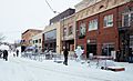
A view of Loveland, Colorado
-

The flag of Loveland, Colorado
-
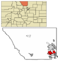
Map showing Loveland's location in Larimer County
See also
 In Spanish: Loveland (Colorado) para niños
