Westminster, Colorado facts for kids
Quick facts for kids
Westminster, Colorado
|
||
|---|---|---|
| City of Westminster | ||
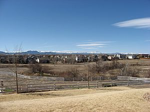
Houses in Westminster with the Front Range in the background.
|
||
|
||
|
||
| Country | ||
| State | ||
| Counties | Jefferson County Adams County |
|
| City | Westminster | |
| Settled | 1859 | |
| Platted | 1885 as DeSpain Junction, later Harris | |
| Incorporated | April 4, 1911, as the Town of Westminster | |
| Government | ||
| • Type | Home rule municipality | |
| Area | ||
| • Total | 33.898 sq mi (87.796 km2) | |
| • Land | 31.585 sq mi (81.806 km2) | |
| • Water | 2.313 sq mi (5.990 km2) | |
| Elevation | 5,325 ft (1,623 m) | |
| Population
(2020)
|
||
| • Total | 116,317 | |
| • Rank | 8th in Colorado 250th in the United States |
|
| • Metro | 2,963,821 (19th) | |
| • CSA | 3,623,560 (17th) | |
| • Front Range | 5,055,344 | |
| Time zone | UTC−07:00 (MST) | |
| • Summer (DST) | UTC−06:00 (MDT) | |
| ZIP codes |
80003, 80005, 80020-80021, 80023, 80030-80031, 80221, 80234, 80241, 80260
|
|
| Area code(s) | Both 303 and 720 | |
| FIPS code | 08-83835 | |
| GNIS feature ID | 2412237 | |
The City of Westminster is a special kind of city, called a home rule municipality. It is located in Adams and Jefferson counties in Colorado, United States. In 2020, about 116,317 people lived there. This makes Westminster the eighth largest city in Colorado.
Westminster is part of a larger area called the Denver–Aurora–Lakewood, CO Metropolitan Statistical Area. It is also part of the Front Range Urban Corridor, which is a long stretch of cities along the mountains. The city's main government building is about 9 miles (14 km) northwest of the Colorado State Capitol in Denver.
| Top - 0-9 A B C D E F G H I J K L M N O P Q R S T U V W X Y Z |
History of Westminster
In 1858, people found Gold in the South Platte River Valley. This made many people interested in the area that would later become Westminster. Many pioneers from the eastern United States decided to settle in Colorado. They were encouraged by the chance to find gold and by the Homestead Act of 1862. This act allowed people to claim land for farming.
Before people settled here, animals like antelope and buffalo lived in the area. There is also proof that Arapaho Native Americans lived near Crown Point (Gregory Hill).
Early Settlers and Farming Life
Westminster's first permanent settler was Pleasant DeSpain, a farmer from Kentucky. He built his home in 1870 on 160 acres of land. This was near where West 76th Avenue and Lowell Street are today. The area became known as DeSpain Junction.
More settlers came, including Edward Bruce Bowles. In 1881, he built a brick Italianate style house. This house is now called the Bowles House. It was added to the National Register of Historic Places in 1988. DeSpain Junction grew into a small farming community. Settlers kept coming, even though farming in Colorado's dry climate was hard.
From DeSpain Junction to Westminster
In 1885, a real estate developer named C.J. Harris arrived. He bought DeSpain's farm and other lands. Harris combined these lands and divided them into smaller plots. He sold these plots to fruit farmers. Harris then renamed DeSpain Junction after himself, and the area became known as Harris, Colorado.
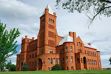
In 1890, Henry T. Mayham from New York convinced a church group to build a university on land he owned in Harris. After some delays, the school was built from red sandstone. This stone came from Colorado's Red Rocks area. The school was designed to be like Princeton University. People called it the "Princeton of the West."
The school was officially named Westminster University of Colorado. Classes started in 1908. One year of tuition cost $50 back then. The school closed in 1917 because all the students left to fight in World War I. Later, it was used as a church and another school.
In 1911, the people of Harris voted to become an official city. They changed the city's name to Westminster. This was done to honor the university, which is now a historic landmark.
In July 2006, Money magazine said Westminster was the 24th best place to live in the United States.
Westminster's Bell Tower
Westminster City Hall has a tall, 14-story bell tower. It has a pyramid-shaped steel mesh top. This 130-foot (40-meter) spire is a well-known landmark in the community. It was designed to look like the famous clock tower of Westminster Palace in England, known as Big Ben.
The bell tower was officially opened in 1986. The mayor of Westminster, England even came for the event. Today, you can see an English Oak tree on the City Hall property. It was a gift to Westminster, Colorado, from Westminster, England.
Where is Westminster?
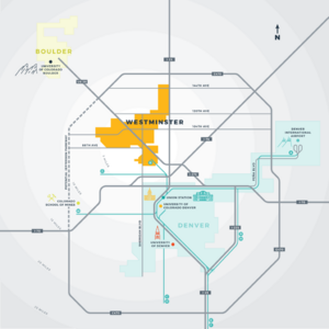
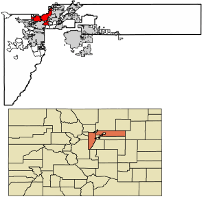
Westminster is located in the western part of Adams County and the northeastern part of Jefferson County. It shares borders with several other cities. To the north is Broomfield. To the northeast is Thornton. To the east are Northglenn and Federal Heights. To the southeast are Sherrelwood, Twin Lakes, and Berkley. To the south is Arvada.
In 2020, the city covered a total area of about 33.89 square miles (87.796 square kilometers). About 2.31 square miles (5.990 square kilometers) of this area is water.
People of Westminster
| Historical population | |||
|---|---|---|---|
| Census | Pop. | %± | |
| 1920 | 235 | — | |
| 1930 | 436 | 85.5% | |
| 1940 | 534 | 22.5% | |
| 1950 | 1,686 | 215.7% | |
| 1960 | 13,850 | 721.5% | |
| 1970 | 19,512 | 40.9% | |
| 1980 | 50,211 | 157.3% | |
| 1990 | 74,625 | 48.6% | |
| 2000 | 100,940 | 35.3% | |
| 2010 | 106,114 | 5.1% | |
| 2020 | 116,317 | 9.6% | |
| U.S. Decennial Census | |||
According to the 2020 United States Census, Westminster had a population of 116,317 people.
In 2000, there were 100,940 people living in the city. About 35.7% of households had children under 18 years old. The average household had 2.62 people. The average family had 3.15 people.
The population was spread out by age. About 26.9% were under 18. About 36.0% were between 25 and 44 years old. The average age was 33 years.
Getting Around Westminster
Westminster has several main roads that go through it. These include I-25, US 36, and US 287. Other important roads are SH 95, SH 121, and SH 128.
The Denver Regional Transportation District (RTD) offers bus services in Westminster. Their Flatiron Flyer is a fast bus service that connects Westminster to Boulder and Denver. It uses special express lanes on US 36.
The RTD also has a park-n-Ride lot at Westminster Center. Many people use this lot to park their cars and take the bus.
In 2016, the RTD opened the B Line. This is a commuter train service that runs between downtown Denver and Westminster Station. This train line helps people travel quickly from Westminster's historic center to Denver's Union Station. From Union Station, riders can connect to other train lines, buses, and downtown shuttles.
For air travel, Westminster is served by Denver International Airport. The nearby Rocky Mountain Metropolitan Airport also serves the area.
Westminster's Economy
Several important companies have their main offices in Westminster. These include DigitalGlobe, Ball, and the Western Fuels Association.
Top Employers in Westminster
Westminster has many leading companies in different fields like technology, medicine, and energy. Here are some of the top employers in Westminster in 2019, based on how many people they employed:
- Ball Corporation
- Maxar
- St. Anthony's North Hospital
- Trimble Navigation
- Alliance Data Systems
- Tri-State Generation and Transmission Association
- MTech Mechanical Technologies Group
- ReedGroup
- Epsilon
- CACI International
Education in Westminster
There are several high schools in or near Westminster. These include:
- The Academy of Charter Schools
- Hidden Lake High School
- Jefferson Academy High School
- Legacy High School
- Mountain Range High School
- Northglenn High School
- Pomona High School
- Standley Lake High School
- Westminster High School
In 2010, the Adams County School District 50 opened a new Westminster High School. This new school replaced the old Westminster High School and Ranum High School.
Shepherd of the Valley Lutheran School is a Christian school in Westminster. It teaches students from pre-kindergarten through 8th grade.
Parks and Open Spaces
Westminster has many trails and open spaces. A great part of the trail system is the Big Dry Creek Trail. It is about 12 miles (19 km) long and goes from the east side of the city to Standley Lake. Other trails follow the Farmers' High Line Canal, Walnut Creek, and Little Dry Creek.
Westminster started protecting open spaces in 1985. Voters approved a special sales tax to buy and take care of these areas. The city now owns over 3,000 acres of open land. Large areas have been saved in the Standley Lake Regional Park and the Westminster Hills area.
Westminster City Park, City Park Recreation Center, and many other parks offer different fun activities. Westminster also has several golf courses, like Legacy Ridge Golf Course and The Heritage Golf Course at Westmoor.
Downtown Westminster is connected to the new U.S. 36 Bikeway. This bikeway links to the largest trail system in the Front Range, which has over 145 miles (233 km) of trails.
Shopping and Entertainment
Westminster is home to The Orchard Town Center. This is an outdoor mall with over 90 stores, restaurants, and entertainment options. It is located where I-25 and 144th Avenue meet.
The city's main mall used to be the Westminster Mall. It was torn down in 2012 to make way for the new Downtown Westminster area.
Downtown Westminster Development
Downtown Westminster is a 105-acre area located almost exactly between downtown Denver and Boulder. This new downtown will have 18 acres of parks and public spaces. It will use Smart City technology to save water and energy. This includes smart streetlights, parking garages, and parking meters.
Building started with over 300 new homes, including 118 affordable housing units. Downtown Westminster now has an Alamo Drafthouse Cinema and a 125-room hotel called the Origin Hotel.
The plans for Downtown Westminster include 300 hotel rooms, 2,300 homes (apartments, condos, and townhouses), 2 million square feet of office space, and 750,000 square feet of shopping areas.
Notable People from Westminster
Many interesting people have lived in Westminster. These include:
- Mariah Bell, a figure skater
- Frank Willis Mayborn, a newspaper publisher from Texas
- Pete Morrison, a silent film actor
See also
 In Spanish: Westminster (Colorado) para niños
 | Emma Amos |
 | Edward Mitchell Bannister |
 | Larry D. Alexander |
 | Ernie Barnes |


