
Adams County, Colorado facts for kids
Quick facts for kids
Adams County
|
||
|---|---|---|

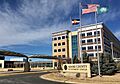
Adams County Government Center in Brighton
|
||
|
||

Location within the U.S. state of Colorado
|
||
 Colorado's location within the U.S. |
||
| Country | ||
| State | ||
| Founded | April 15, 1901 | |
| Named for | Alva Adams | |
| Seat | Brighton | |
| Largest city | Thornton | |
| Area | ||
| • Total | 1,184 sq mi (3,070 km2) | |
| • Land | 1,168 sq mi (3,030 km2) | |
| • Water | 16 sq mi (40 km2) 1.4%% | |
| Population
(2020)
|
||
| • Total | 519,572 | |
| • Estimate
(2023)
|
533,365 |
|
| • Density | 438.83/sq mi (169.43/km2) | |
| Time zone | UTC−7 (Mountain) | |
| • Summer (DST) | UTC−6 (MDT) | |
| Congressional districts | 4th, 6th, 7th, 8th | |
|
|
||

Adams County is a county located in the state of Colorado in the United States. It's a busy and growing area! In 2020, about 519,572 people lived here. The main town where the county government is located is Brighton. The biggest city in Adams County is Thornton.
The county is named after Alva Adams. He was an early Governor of Colorado from 1887 to 1889. Adams County is part of the larger Denver area, which includes cities like Denver, Aurora, and Lakewood.
Contents
History of Adams County
How Adams County Began
The story of Adams County starts a long time ago. On May 30, 1854, the U.S. government created two new areas called the Territory of Nebraska and the Territory of Kansas. These territories were divided by a line called the 40th parallel north. This line is now known as 168th Avenue in Adams County. The land that would become Adams County was in the northern part of the Kansas Territory.
Early Settlements and Gold Rush
In 1859, a man named John D. "Colonel Jack" Henderson built a ranch and trading post on an island in the South Platte River. This was in the Kansas Territory. He sold food and supplies to people who were traveling to the gold fields during the Pike's Peak Gold Rush. Henderson Island was the first permanent settlement in this river valley. Today, this spot is where the Adams County Regional Park and Fairgrounds are located.
Becoming Part of Colorado
The eastern part of the Kansas Territory became the State of Kansas in 1861. The remaining western part, which included the future Adams County, became part of the new Colorado Territory on February 28, 1861. Later, on August 1, 1876, Colorado officially became a state.
Forming Adams County
In 1901, the Colorado government decided to divide Arapahoe County into three parts. These parts were a new Adams County, the City and County of Denver, and a smaller Arapahoe County. It took a little while for everything to be official. Adams County was finally created on November 15, 1902.
Governor James Bradley Orman chose Brighton as the temporary county seat. This is the main town for the county government. Adams County was originally very long, stretching about 160 miles (257 km) from Sheridan Boulevard to the Kansas border.
Changes to County Borders
In 1903, the eastern part of Adams County was given to two new counties: Washington County and Yuma County. This made Adams County shorter, about 72 miles (116 km) long. In 1904, people in Adams County voted to make Brighton the permanent county seat.
Later, in 1989, about 53 square miles (137 km²) of Adams County land was transferred to the City and County of Denver. This land was used to build the Denver International Airport. In 2001, Adams County lost a small piece of its northwest corner when the City and County of Broomfield was created.
Geography of Adams County
Adams County covers a total area of about 1,184 square miles (3,066 km²). Most of this area is land, with only a small part being water. Interestingly, Adams County surrounds most of the Denver International Airport, even though the airport itself is part of the City and County of Denver.
Neighboring Counties
Adams County shares borders with several other counties:
- Weld County – to the north
- Morgan County – to the northeast
- Washington County – to the east
- Arapahoe County – to the south
- City & County of Denver – to the southeast
- Jefferson County – to the west
- City & County of Broomfield – to the northwest
Main Roads and Highways
Many important roads and highways run through Adams County, helping people travel around Colorado and beyond. These include:
 Interstate 25
 Interstate 70
 Interstate 76
 Interstate 225
 Interstate 270
 I-70 Bus.
 U.S. Highway 6
 U.S. Highway 36
 U.S. Highway 40
 U.S. Highway 85
 U.S. Highway 287
 State Highway 2
 State Highway 7
 State Highway 36
 State Highway 40
 State Highway 44
 State Highway 79
 State Highway 128
 State Highway 224
 State Highway 265
- E-470 (a toll road)
Nature and Recreation
Adams County has some great places for nature and outdoor activities:
- Rocky Mountain Arsenal National Wildlife Refuge: A large area dedicated to protecting wildlife.
- Barr Lake State Park: A state park perfect for birdwatching, fishing, and boating.
Historic and Recreational Trails
You can also find several trails for hiking and exploring:
- South Platte Trail: A historic trail that follows the South Platte River.
- American Discovery Trail: A very long trail that crosses the entire United States.
- Big Dry Creek National Recreation Trail
- Highline Canal National Recreation Trail
- Platte River Greenway National Recreation Trail
- Rocky Mountain Arsenal National Recreation Trail
Population of Adams County
The number of people living in Adams County has grown a lot over the years. Here's how the population has changed:
| Historical population | |||
|---|---|---|---|
| Census | Pop. | %± | |
| 1910 | 8,892 | — | |
| 1920 | 14,430 | 62.3% | |
| 1930 | 20,245 | 40.3% | |
| 1940 | 22,481 | 11.0% | |
| 1950 | 40,234 | 79.0% | |
| 1960 | 120,296 | 199.0% | |
| 1970 | 185,789 | 54.4% | |
| 1980 | 245,944 | 32.4% | |
| 1990 | 265,038 | 7.8% | |
| 2000 | 363,857 | 37.3% | |
| 2010 | 441,603 | 21.4% | |
| 2020 | 519,572 | 17.7% | |
| 2023 (est.) | 533,365 | 20.8% | |
| U.S. Decennial Census 1790-1960 1900-1990 1990-2000 2010-2020 |
|||
In 2000, the average age of people in Adams County was 31 years old. This means it's a relatively young and active community.
Education in Adams County
Adams County is home to many schools and school districts that help students learn and grow.
Here are some of the school districts serving the county:
- Adams 12 Five Star Schools
- Adams-Arapahoe School District 28J
- Adams County School District 14
- Bennett School District 29-J
- Byers School District 32J
- Deer Trail School District 26J
- Mapleton School District 1
- School District 27J
- Strasburg School District 31J
- Weld County School District RE-3J
- Westminster Public School District
- Wiggins School District RE-50J
The county also has a campus of Front Range Community College in Westminster. This is the largest community college in Colorado, offering many different programs for students after high school.
Communities in Adams County
Adams County has many different cities, towns, and smaller communities where people live and work.
Cities
- Arvada (part)
- Aurora (part)
- Brighton (part)
- Commerce City
- Federal Heights
- Northglenn (part)
- Thornton (most)
- Westminster (part)
Towns
Census-Designated Places (CDPs)
These are areas that are like towns but are not officially incorporated as cities or towns.
- Berkley
- Derby
- North Washington
- Shaw Heights
- Sherrelwood
- Strasburg (mostly in Arapahoe Co.)
- Todd Creek
- Twin Lakes
- Watkins (mostly in Arapahoe Co.)
- Welby
Other Unincorporated Communities
These are smaller communities that are not part of any city or town.
- Adams City
- Barr Lake
- Cabin Creek
- Comanche
- Dupont
- Eastlake
- Hazeltine
- Henderson
- Leader
- Living Springs
- Manila
Images for kids
-
Adams County Government Center in Brighton
See also
 In Spanish: Condado de Adams (Colorado) para niños
