Broomfield, Colorado facts for kids
Quick facts for kids
Broomfield
|
|||
|---|---|---|---|
 |
|||
|
|||

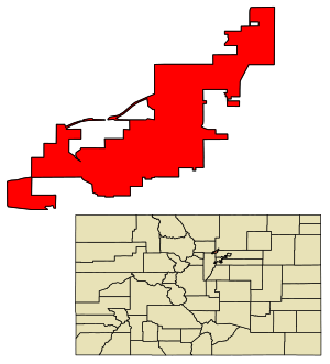
Location of the City and County of Broomfield in Colorado
|
|||
| Country | |||
| State | |||
| City and County | Broomfield | ||
| Incorporated | June 6, 1961 | ||
| Consolidated | November 15, 2001 | ||
| Named for | The broomcorn once grown in the area | ||
| Government | |||
| • Type | Consolidated city and county | ||
| Area | |||
| • Total | 33.548 sq mi (86.890 km2) | ||
| • Land | 32.968 sq mi (85.387 km2) | ||
| • Water | 0.580 sq mi (1.503 km2) | ||
| Elevation | 5,348 ft (1,630 m) | ||
| Population
(2020)
|
|||
| • Total | 74,112 | ||
| • Estimate
(2023)
|
76,860 |
||
| • Density | 2,209.106/sq mi (852.940/km2) | ||
| • Metro | 2,963,821 (19th) | ||
| • CSA | 3,623,560 (17th) | ||
| • Front Range | 5,055,344 | ||
| Time zone | UTC−07:00 (MST) | ||
| • Summer (DST) | UTC−06:00 (MDT) | ||
| ZIP codes |
80020, 80021, 80023,
80038 (PO Box) |
||
| Area code | 303 and 720 | ||
| FIPS code | 08-09280 | ||
| GNIS ID | 2409919 | ||
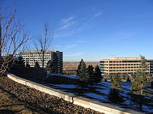
Broomfield is a special kind of city and county located in the state of Colorado, United States. It has a combined government that works under the state's constitution. In 2020, about 74,112 people lived in Broomfield. This makes it one of the most populated cities and counties in Colorado. Broomfield is also part of the larger Denver metropolitan area.
Contents
History of Broomfield
The Broomfield post office first opened on September 26, 1884. Many historians believe the town was named after a plant called sorghum, also known as broomcorn. The stalks of this plant were used to make brooms.
Several railroads helped Broomfield grow. The Colorado Central Railroad built a narrow-gauge line in 1873. Later, the Denver, Utah and Pacific Railroad arrived in 1881. The Denver, Marshall and Boulder Railway also built a line through the area in 1886. One early name for the area was Zang's Spur, named after a railroad line that served Adolph Zang's grain fields.
The Denver–Boulder Turnpike
The Denver–Boulder Turnpike was built to make car travel faster between Denver, the state capital, and Boulder, a university city. Construction started in 1950, and the road opened on January 19, 1952. The only toll booth was in Broomfield. It cost 10 cents to travel from Adams County to Broomfield and 15 cents from Broomfield to Boulder. The whole trip cost 25 cents.
The City of Broomfield officially became a city on June 6, 1961. It was first located in the southeastern part of Boulder County. Because the Denver–Boulder Turnpike was a popular way to travel for work, Broomfield became a popular place to live. On September 14, 1967, the turnpike became free to use because its building costs were paid off. It then became the official route for U.S. Route 36. This turnpike was the first public toll road in the U.S. to become free.
Becoming a Consolidated City and County
By the 1990s, Broomfield had grown a lot. It had expanded into Adams, Jefferson, and Weld counties, as well as Boulder County. City leaders found it difficult to work with four different county governments. They wanted Broomfield to have its own county government, like Denver. This would allow them to provide services more easily.
The city asked for a change to the state constitution to create a new county. This change was approved in 1998. After three years of preparation, Broomfield County officially became Colorado's 64th county on November 15, 2001. It is the newest and smallest county in Colorado.
Geography of Broomfield
Broomfield is located between Denver and Boulder. You can find it along U.S. Routes 36 and 287. The city's elevation is about 5,348 feet (1,630 meters) above sea level.
In 2020, Broomfield covered a total area of about 86.890 square kilometers (33.548 square miles). A small part of this area, about 1.503 square kilometers (0.580 square miles), is water. Broomfield is the smallest county by area in Colorado.
Airport
Rocky Mountain Metropolitan Airport is located in Broomfield.
Major Highways
 Interstate 25
 U.S. Route 36 (Denver–Boulder Turnpike)
 U.S. Route 85
 U.S. Route 287
 State Highway 7
 State Highway 121
 State Highway 128
- E-470 (toll road)
- Northwest Parkway (toll road)
Neighboring Counties
- Weld County — to the northeast
- Adams County — to the southeast
- Jefferson County — to the southwest
- Boulder County — to the northwest
Climate
Broomfield has a cold semi-arid climate. This means it's generally dry with cold winters. The average lowest temperature in winter is around -9.4°C (15°F).
| Climate data for City and County of Broomfield, CO. Elevation 5407 ft | |||||||||||||
|---|---|---|---|---|---|---|---|---|---|---|---|---|---|
| Month | Jan | Feb | Mar | Apr | May | Jun | Jul | Aug | Sep | Oct | Nov | Dec | Year |
| Mean daily maximum °F (°C) | 45.4 (7.4) |
47.5 (8.6) |
54.6 (12.6) |
62.3 (16.8) |
71.6 (22.0) |
81.9 (27.7) |
88.7 (31.5) |
86.2 (30.1) |
78.1 (25.6) |
65.8 (18.8) |
53.0 (11.7) |
44.7 (7.1) |
65.1 (18.4) |
| Mean daily minimum °F (°C) | 18.3 (−7.6) |
20.2 (−6.6) |
27.0 (−2.8) |
33.8 (1.0) |
43.0 (6.1) |
51.7 (10.9) |
57.6 (14.2) |
56.2 (13.4) |
47.3 (8.5) |
35.9 (2.2) |
25.7 (−3.5) |
18.0 (−7.8) |
36.3 (2.4) |
| Average precipitation inches (mm) | 0.44 (11) |
0.43 (11) |
1.64 (42) |
2.07 (53) |
2.26 (57) |
1.73 (44) |
1.76 (45) |
1.86 (47) |
1.26 (32) |
1.12 (28) |
0.87 (22) |
0.68 (17) |
16.12 (409) |
| Average relative humidity (%) | 50.5 | 51.1 | 48.0 | 45.8 | 49.6 | 46.8 | 44.2 | 48.5 | 46.1 | 47.2 | 49.8 | 51.8 | 48.3 |
| Average dew point °F (°C) | 15.6 (−9.1) |
17.7 (−7.9) |
22.6 (−5.2) |
28.2 (−2.1) |
38.6 (3.7) |
45.8 (7.7) |
50.0 (10.0) |
50.8 (10.4) |
41.7 (5.4) |
31.4 (−0.3) |
22.2 (−5.4) |
15.6 (−9.1) |
31.8 (−0.1) |
| Source: PRISM Climate Group | |||||||||||||
Ecology
The natural plant life in Broomfield is mostly shortgrass prairie. This means you would find grasses like Bouteloua and buffalograss growing there naturally.
People of Broomfield (Demographics)
| Historical population | |||
|---|---|---|---|
| Census | Pop. | %± | |
| 1960 | 4,535 | — | |
| 1970 | 7,261 | 60.1% | |
| 1980 | 20,730 | 185.5% | |
| 1990 | 24,638 | 18.9% | |
| 2000 | 38,272 | 55.3% | |
| 2010 | 55,889 | 46.0% | |
| 2020 | 74,112 | 32.6% | |
| 2023 (est.) | 76,860 | 37.5% | |
| U.S. Decennial Census | |||
Broomfield is part of the larger Denver metropolitan area.
In 2020, about 74,112 people lived in Broomfield. It is the second most crowded county in Colorado, after Denver. Most residents (76.0%) were White, 6.9% were Asian, and 1.3% were African American. About 13.4% of the population was Hispanic or Latino. By 2023, about 8.8% of the people living in Broomfield were born outside the U.S.
In 2023, there were about 33,563 households. About 48.0% of these were married couples. Around 22.5% of households had at least one person under 18 years old. Also, 25.6% of households had at least one person aged 65 or older. The average household had 2.28 people.
About 20.2% of Broomfield residents were under 18 years old in 2023. About 16.5% were 65 years or older. The average age of people in Broomfield was 37.9 years. Females made up 49.1% of the population.
In 2023, the average household income in Broomfield was $112,139. The average family income was $130,920. Broomfield had one of the highest average incomes in Colorado. Most adults (97.0%) had graduated from high school or higher. Many (58.8%) had a bachelor's degree or higher.
Economy
In the 1990s, Broomfield and other nearby areas grew very quickly. Much of this growth was in technology companies.
FlatIron Crossing is a large shopping and entertainment center in Broomfield. It has popular stores like Dick's Sporting Goods, Macy's, and Forever 21.
Several well-known companies have their main offices in Broomfield. These include Crocs, Vail Resorts, MWH Global, Flatiron Construction, Webroot, Noodles & Company, and Mrs. Fields.
Top Employers
Here are some of the biggest employers in Broomfield, based on a 2023 report:
| # | Employer | # of Employees |
|---|---|---|
| 1 | Oracle America | 1,650 |
| 2 | Intermountain Health Care | 1,550 |
| 3 | BAE Systems | 1,100 |
| 4 | Hunter Douglas Window Fashions Division | 950 |
| 5 | City and County of Broomfield | 900 |
| 6 | Vail Resorts | 750 |
| 7 | DanoneWave Foods | 600 |
| 8 | Crocs | 600 |
| 9 | Broadcom Inc. | 500 |
| 10 | VMware | 450 |
Media
The local newspaper in Broomfield is the Broomfield Enterprise. KBDI-TV, a public television station for the Denver area, is also based in Broomfield.
Fun Things to Do (Recreation)
Broomfield offers many fun things to do. You can visit the Paul Derda Recreation Center, which has a pool, athletic fields, and courts. There are also many open spaces and trails for outdoor activities.
Broomfield has a large system of trails that connect different lakes and parks. A beautiful trail links Stearns Lake and the Josh's Pond memorial. Broomfield also has a 9/11 memorial that includes a piece of steel from one of the towers.
There is also a skate park in Broomfield with bowls, a large half-pipe, and other features for skateboarding.
The Broomfield Community Center was updated in 2020. It offers many fitness classes, activities for older adults, and hosts swim meets and kids' camps.
Many Broomfield residents enjoy playing tennis and golf. There are several golf courses and tennis courts open to everyone. The Community Center also hosts pickleball games and tournaments.
Education
Because Broomfield used to be part of four different counties, students living there went to different school districts. Even though it's now one county, students still attend schools in six different districts:
- Boulder Valley School District
- 27J Schools
- Weld County School District RE-8
- Jefferson County Public Schools
- St. Vrain Valley School District
- Adams 12 Five Star Schools
Four of Colorado's ten largest school districts have parts in Broomfield.
Broomfield has two large public high schools: Broomfield High School and Legacy High School. There are also two public middle schools and eight public elementary schools. For private education, there are four schools: Brightmont Academy, Broomfield Academy, Holy Family (a Catholic high school), and Nativity of Our Lord Parish (a Catholic elementary school). Broomfield also has two K–12 charter schools: Prospect Ridge Academy and Front Range Academy.
Famous People from Broomfield
Here are some notable people who were born in or have lived in Broomfield:
- Mark Boslough, a physicist
- Drew Brown, a musician and guitarist for the band OneRepublic
- Dianne Primavera, a former Lieutenant Governor of Colorado
- Anna Prins, a basketball player
- Vince Russo, a pro wrestling personality
- Steve Schmuhl, a swimmer
- Mike Wilpolt, a football player and coach
- Cat Zingano, a mixed martial arts (MMA) fighter
Sister City
Broomfield has a sister city, which is a city in another country that it shares a special friendship with:
 Ueda, Nagano Prefecture, Japan
See also
 In Spanish: Broomfield para niños
 | Precious Adams |
 | Lauren Anderson |
 | Janet Collins |


