
Boulder County, Colorado facts for kids
Quick facts for kids
Boulder County
|
||
|---|---|---|
.jpg)
Boulder County Courthouse
|
||
|
||

Location within the U.S. state of Colorado
|
||
 Colorado's location within the U.S. |
||
| Country | ||
| State | ||
| Founded | November 1, 1861 | |
| Named for | large granite boulders in area | |
| Seat | Boulder | |
| Largest city | Boulder | |
| Area | ||
| • Total | 740 sq mi (1,900 km2) | |
| • Land | 726 sq mi (1,880 km2) | |
| • Water | 14 sq mi (40 km2) 1.9%% | |
| Population
(2020)
|
||
| • Total | 330,758 | |
| • Density | 460/sq mi (176/km2) | |
| Time zone | UTC−7 (Mountain) | |
| • Summer (DST) | UTC−6 (MDT) | |
| Congressional districts | 2nd, 4th | |

Boulder County is a county in the state of Colorado in the United States. In 2020, about 330,758 people lived there. The biggest city and the main government center is Boulder.
Boulder County is part of a larger area called the Boulder, Colorado Metropolitan Statistical Area. This area is also included in the bigger Denver–Aurora, Colorado Combined Statistical Area.
Contents
History of Boulder County
Boulder County was one of the first 17 counties created in the Territory of Colorado on November 1, 1861. It was named after Boulder City and Boulder Creek. These places got their names because of the many large boulders found in the creek. These boulders made it hard for early gold miners to find gold.
The borders of Boulder County are mostly the same as they were in 1861. However, in 2001, a part of its southeastern corner became part of the City and County of Broomfield.
Before the first US settlers arrived, Native American tribes lived in the area. Chief Niwot led tribes on the plains, and Utes lived in the mountains during certain seasons. The first European American settlers were gold prospectors led by Captain Thomas Aikins. His group settled near Boulder Creek Canyon in October 1858. Chief Niwot told them not to stay.
In February 1859, the settlers founded the town of Boulder. Around the same time, they also started the first gold mining town in Colorado, called Gold Hill. This town is about 10 miles west of Boulder. Gold Hill was important because a lot of gold was found there. It was the site of Colorado's first large-scale gold mine, which produced over 5,500 ounces of gold in its first year.
In December 2021, a very destructive fire called the Marshall Fire happened near Boulder, Colorado. This fire is known as the most damaging fire in Colorado's history. It affected the cities of Superior and Louisville, as well as other areas in Boulder County. The fire destroyed 991 homes and damaged 127 others. More than 13,000 people in Superior and 21,000 in Louisville had to leave their homes because of strong winds (up to 100 miles per hour) that spread the fire quickly. The cause of the fire is still being investigated.
Geography of Boulder County

Boulder County covers a total area of about 740 square miles. Most of this (726 square miles) is land, and 14 square miles (1.9%) is water.
Neighboring Counties
- Larimer County, Colorado – to the north
- Weld County, Colorado – to the east
- City and County of Broomfield, Colorado – to the southeast
- Jefferson County, Colorado – to the south
- Gilpin County, Colorado – to the south
- Grand County, Colorado – to the west
Main Roads
 U.S. Highway 36 (also known as the Denver-Boulder Turnpike)
 U.S. Highway 287
 State Highway 7
 State Highway 42
 State Highway 52
 State Highway 66
 State Highway 72
 State Highway 93
 State Highway 119
 State Highway 170
- Northwest Parkway (a toll road)
Protected Natural Areas
- Arapaho National Forest
- Roosevelt National Forest
- Indian Peaks Wilderness
- James Peak Wilderness
- Rocky Mountain National Park (shared with Larimer and Grand Counties)
- Longs Peak, the highest point in the park, is in Boulder County.
State Parks
Fun Trails and Drives
- Continental Divide National Scenic Trail
- Peak to Peak Scenic and Historic Byway
Historic Places
People of Boulder County
| Historical population | |||
|---|---|---|---|
| Census | Pop. | %± | |
| 1870 | 1,939 | — | |
| 1880 | 9,723 | 401.4% | |
| 1890 | 14,082 | 44.8% | |
| 1900 | 21,544 | 53.0% | |
| 1910 | 30,330 | 40.8% | |
| 1920 | 31,861 | 5.0% | |
| 1930 | 32,456 | 1.9% | |
| 1940 | 37,438 | 15.4% | |
| 1950 | 48,296 | 29.0% | |
| 1960 | 74,254 | 53.7% | |
| 1970 | 131,889 | 77.6% | |
| 1980 | 189,625 | 43.8% | |
| 1990 | 226,374 | 19.4% | |
| 2000 | 271,651 | 20.0% | |
| 2010 | 294,567 | 8.4% | |
| 2020 | 330,758 | 12.3% | |
| 2023 (est.) | 326,831 | 11.0% | |
| U.S. Decennial Census 1790-1960 1900-1990 1990-2000 2010-2020 |
|||
In 2000, there were 271,651 people living in Boulder County. The population density was about 392 people per square mile. Most people (88.54%) were White. About 10.46% of the people were Hispanic or Latino.
The average age of people in the county was 33 years old. In 2014, the average income for a family was $94,938.
In 2017, Bloomberg magazine said that the Boulder area was the top "brain" area in the US. This means it has a lot of smart and educated people.
Communities in Boulder County

Cities
- Boulder
- Lafayette
- Longmont (partly in Weld County)
- Louisville
Towns
- Erie (partly in Weld County)
- Jamestown
- Lyons
- Nederland
- Superior (partly in Jefferson County)
- Town of Ward
Census-Designated Places
These are areas that are like towns but are not officially incorporated as cities or towns.
- Allenspark
- Altona
- Bark Ranch
- Bonanza Mountain Estates
- Coal Creek (partly in Gilpin County and Jefferson County)
- Crisman
- Eldora
- Eldorado Springs
- Glendale
- Gold Hill
- Gunbarrel
- Hidden Lake
- Lazy Acres
- Leyner
- Mountain Meadows
- Niwot
- Paragon Estates
- Pine Brook Hill
- Seven Hills
- St. Ann Highlands
- Sugarloaf
- Sunshine
- Tall Timber
- Valmont
Other Unincorporated Communities
These are smaller communities that are not officially part of a city or town.
- Caribou
- Canfield
- Gooding
- Hygiene
- Highland
- Liggett
- Morey
- Pinecliffe
- Pleasant View Ridge (partly in Weld County)
- Tabor
Education in Boulder County
Several school districts serve the students in Boulder County:
- Boulder Valley School District RE-2
- Estes Park School District R-3
- St. Vrain Valley School District RE-1J
- Thompson School District R-2J
Images for kids
-
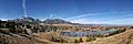
A wide view of Boulder and the mountains to the west.
See also
 In Spanish: Condado de Boulder para niños
