Sunshine, Colorado facts for kids
Quick facts for kids
Sunshine, Colorado
|
|
|---|---|

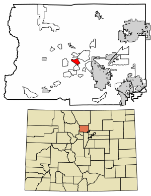
Location of the Sunshine CDP in Boulder County, Colorado
|
|
| Country | |
| State | |
| County | Boulder County |
| Government | |
| • Type | unincorporated community |
| Area | |
| • Total | 4.481 km2 (1.730 sq mi) |
| • Land | 4.481 km2 (1.730 sq mi) |
| • Water | 0.000 km2 (0 sq mi) |
| Elevation | 2,239 m (7,346 ft) |
| Population
(2020)
|
|
| • Total | 198 |
| • Density | 44.19/km2 (114.44/sq mi) |
| Time zone | UTC-7 (MST) |
| • Summer (DST) | UTC-6 (MDT) |
| ZIP Code |
Boulder 80302
|
| Area codes | 303 & 720 |
| GNIS feature ID | 2583302 |
Sunshine is a small community in Boulder County, Colorado, United States. It is also known as Sunshine Canyon. This area is called an unincorporated community, which means it doesn't have its own city government. It's also a census-designated place (CDP), which is a special area defined by the government for counting people.
Sunshine is part of the larger Boulder, Colorado area. In 2020, about 198 people lived in Sunshine. The mail for Sunshine is handled by the Boulder post office, using the Zip Code 80302.
Contents
History of Sunshine
Gold Discovery and Mining Boom
In 1873, people found gold ore in Sunshine. This discovery brought many prospectors, or gold seekers, to the area. They hoped to find their fortune. By 1876, Sunshine had grown into a busy mining camp. Its population reached 1,200 people.
At its peak, Sunshine had many businesses and services. There was a post office, a school, and a newspaper called The Sunshine Courier. The community also had hotels, boarding houses, two general stores (called mercantile firms), three blacksmiths, and two saloons.
The Historic Schoolhouse
In 1900, Sunshine built a stone schoolhouse. This building is still in great shape today. It is used for different community events. The schoolhouse is known for its strong construction and beautiful design. Because of its importance, it was added to the National Register of Historic Places in 1989.
Decline of Mining and Community Change
Over time, finding and digging for gold became harder. Most of the mines in Sunshine eventually closed down. By 1908, Sunshine's population had dropped to about 200 people. After World War I, ranching became more common in the area. Only a few mines continued to operate.
The remaining mines were finally closed in July 1942. This happened because President Franklin D. Roosevelt issued a special order. The United States needed to focus on making materials for the war effort.
Geography of Sunshine
Sunshine is located in the middle of Boulder County. It sits in the hills to the northwest of the city of Boulder. To the south, it borders the Crisman CDP. The Glendale and Lazy Acres CDPs are to the north.
The Sunshine CDP covers an area of about 4.481 square kilometers (1.730 square miles). All of this area is land.
Population Data
The United States Census Bureau first defined Sunshine as a CDP for the United States Census 2010. This means they officially counted the population for this specific area.
| Sunshine CDP, Colorado | ||
|---|---|---|
| Year | Pop. | ±% |
| 2010 | 230 | — |
| 2020 | 198 | −13.9% |
| Source: United States Census Bureau | ||
See also
 In Spanish: Sunshine (Colorado) para niños


