Crisman, Colorado facts for kids
Quick facts for kids
Crisman, Colorado
|
|
|---|---|

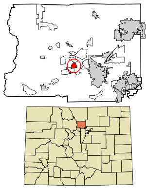
Location of the Crisman CDP in Boulder County, Colorado
|
|
| Country | |
| State | |
| County | Boulder County |
| Founded | 1874 |
| Government | |
| • Type | unincorporated community |
| Area | |
| • Total | 3.774 km2 (1.457 sq mi) |
| • Land | 3.774 km2 (1.457 sq mi) |
| • Water | 0.0004 km2 (0.0002 sq mi) |
| Elevation | 2,009 m (6,592 ft) |
| Population
(2020)
|
|
| • Total | 179 |
| • Density | 47.43/km2 (122.8/sq mi) |
| Time zone | UTC-7 (MST) |
| • Summer (DST) | UTC-6 (MDT) |
| ZIP Code |
Boulder 80302
|
| Area codes | 303 & 720 |
| GNIS feature ID | 2583229 |
Crisman is a small, unincorporated community in Boulder County, Colorado, United States. It is also known as a census-designated place (CDP). This means the United States Census Bureau defines it for collecting statistics, even though it doesn't have its own city government. In 2020, about 179 people lived in Crisman. The Boulder post office serves the area.
Contents
History of Crisman
Crisman was founded in 1874. It began as a mining camp, which was a place where miners lived and worked. The community was named after the nearby Crisman Mill. This mill processed ore and was owned by an early settler named Obed Crisman.
Boomtown Days and Silver Strikes
In 1881, Crisman became a "boomtown." This happened when the Yellow Pine Mine found a huge amount of silver. A boomtown is a place that grows very quickly because of a sudden economic boost, like a mining discovery. The Greeley, Salt Lake and Pacific Railway even made Crisman a stop on its line.
Economic Challenges and Floods
However, things changed in 1893. The "Panic of 1893" was a big economic crisis in the United States. It caused the price of silver to drop a lot. This severely hurt Crisman's economy, even though some mines stayed open.
In 1894, Boulder Creek flooded. Much of the town was destroyed, including a section of the railroad track. The destroyed buildings were never rebuilt, and Crisman became much smaller.
Gold Discovery and Decline
In 1901, the Logan Mine, a large gold mining operation near Crisman, found another big strike. This helped prevent the town from completely disappearing. However, by 1918, fewer and fewer people lived in Crisman, and the post office closed that year.
In 1919, another terrible flood swept through Fourmile Canyon. It again destroyed a section of railroad track and left very little of Crisman standing. Since then, the town has been reduced to a small settlement, often called a hamlet.
Geography of Crisman
Crisman is located in the middle of Boulder County. It sits in the Front Range of the Colorado Rocky Mountains. The community is in the valley of Fourmile Creek. Its elevation is about 6,578 feet (2,005 meters) above sea level.
Four Mile Canyon Drive is a road that connects Crisman to other places. It leads about 7 miles (11 km) southeast to Boulder. It also goes about 5 miles (8 km) northwest to Gold Hill.
The Crisman CDP covers an area of about 1.46 square miles (3.774 square kilometers). A very small part of this area, about 0.00015 square miles (0.0004 square kilometers), is water.
Crisman Population Data
The United States Census Bureau first defined Crisman as a census-designated place for the United States Census 2010. This means they started counting its population separately for official records at that time.
| Crisman CDP, Colorado | ||
|---|---|---|
| Year | Pop. | ±% |
| 2010 | 186 | — |
| 2020 | 179 | −3.8% |
| Source: United States Census Bureau | ||
See also
 In Spanish: Crisman (Colorado) para niños
 | Emma Amos |
 | Edward Mitchell Bannister |
 | Larry D. Alexander |
 | Ernie Barnes |


