
Boulder, Colorado facts for kids
Quick facts for kids
Boulder
|
||
|---|---|---|

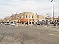
Pearl Street Mall in downtown Boulder
|
||
|
||

Location of Boulder in Boulder County, Colorado
|
||

Boulder
Location in Colorado

Boulder
Location in the United States
|
||
| Country | United States | |
| State | Colorado | |
| County | Boulder | |
| Settled | 1858 as Boulder City, N.T. | |
| Incorporated | November 4, 1871 | |
| Government | ||
| • Type | Home rule municipality | |
| Area | ||
| • Home rule city | 27.366 sq mi (70.877 km2) | |
| • Land | 26.328 sq mi (68.188 km2) | |
| • Water | 1.038 sq mi (2.689 km2) | |
| Elevation | 5,269 ft (1,606 m) | |
| Population
(2020)
|
||
| • Home rule city | 108,250 | |
| • Rank | 12th in Colorado 289th in United States |
|
| • Density | 4,112/sq mi (1,588/km2) | |
| • Metro | 330,758 (155th) | |
| • CSA | 3,623,560 (17th) | |
| • Front Range | 5,055,344 | |
| Demonym(s) | Boulderite | |
| GDP | ||
| • Metro | $35.608 billion (2022) | |
| Time zone | UTC−07:00 (MST) | |
| • Summer (DST) | UTC−06:00 (MDT) | |
| ZIP Codes |
80301-80310, 80314, 80321-80323, 80328, 80329
|
|
| Area codes | 303 and 720 | |
| FIPS code | 08-07850 | |
| GNIS feature ID | 2409883 | |
Boulder is a city in Boulder County, Colorado, United States. It's the main city of the county. In 2020, about 108,250 people lived there. This makes it the 12th largest city in Colorado. Boulder is part of a larger area called the Front Range Urban Corridor.
The city sits at the bottom of the Rocky Mountains. It's about 5,269 feet (1,606 meters) above sea level. Boulder is about 25 miles (40 km) northwest of Denver, the capital of Colorado. It's known as a college town because it's home to the University of Colorado Boulder. This is the biggest campus in the University of Colorado system. Many research centers are also in Boulder.
Contents
- Boulder's History: From Ancient Times to Today
- Boulder's Geography and Environment
- People and Population
- Boulder's Economy and Jobs
- Fun Things to Do in Boulder
- Parks and Outdoor Fun
- Learning and Education
- Media and News
- Getting Around Boulder
- Famous People from Boulder
- Sister Cities Around the World
- Images for kids
- See also
Boulder's History: From Ancient Times to Today
People have lived in the Boulder valley for over 13,000 years. Native American tribes moved between the mountains and plains. They found shelter in the Boulder area during winter. By the 1500s, Ute tribes lived here. Later, Arapaho tribes joined them in the early 1800s. Many Indigenous Nations have ties to this valley. These include the Apache, Cheyenne, Comanche, Kiowa, Pawnee, Shoshone, Sioux, and Ute peoples.
How Boulder Was Founded
Modern Boulder started in late 1858. Gold seekers arrived during the Colorado Gold Rush. An Arapaho leader named Niwot let them stay for the winter. But this decision eventually led to his people losing their land. In early 1859, gold was found along Boulder Creek. This brought more miners and traders to the area. The Boulder City Town Company was formed in February 1859. They wanted to build a settlement at the canyon's opening. By 1860, there were 70 cabins.
In 1861, Boulder County was created. The Arapaho people were forced to move. By 1862, the creek had produced $100,000 in gold. Boulder's population grew to over 300 people.
Growth and Development
On November 7, 1861, the Colorado General Assembly decided to put the University of Colorado in Boulder. The first building, Old Main, started being built on September 20, 1875. The university officially opened on September 5, 1877.
In 1907, Boulder made a rule against selling alcohol in bars. Later, a statewide ban on alcohol started in Colorado in 1916. This ban ended in 1933.

Protecting Boulder's Views
Boulder has worked to control its growth. In 1959, voters approved the "Blue Line" rule. This stopped city water service to higher mountain areas. It helped protect the mountains from too much building. In 1967, people voted for a special tax. This tax helps buy open land to stop the city from spreading out too much. In 1972, the city limited how tall new buildings could be. This was to keep mountain views clear.
Boulder's Geography and Environment

Boulder is in the Boulder Valley. This is where the Rocky Mountains meet the Great Plains. The Flatirons are large, tilted rock slabs west of the city. They are a well-known symbol of Boulder.
Boulder Creek is the main waterway in Boulder. It was named for the many large granite boulders in it. The city is thought to have gotten its name from this creek. The creek gets its water from melting snow and small springs. Boulder Creek flows into St. Vrain Creek to the east.
In 2020, the city covered about 27.37 square miles (70.877 square kilometers). About 1.04 square miles (2.689 square kilometers) of this is water. The 40th parallel (40 degrees north latitude) goes through Boulder. You can see it as Baseline Road today.
Boulder is in a wide basin below Flagstaff Mountain. This is just a few miles east of the continental divide. The Arapahoe Glacier and Boulder Creek provide water for the city.
Protecting Nature in Boulder
Boulder has a plan to manage and protect wildlife in the city. Parks and hiking trails are sometimes closed. This helps protect or restore natural areas.
Boulder usually avoids using chemicals to control insects. But because of the West Nile virus, the city started a plan in 2003. This plan includes some chemical pesticides. Residents can ask for their areas not to be sprayed.
Under Boulder law, you need a permit to remove prairie dogs. In 2005, the city tried using goats to control weeds. Goats eat certain weeds naturally. Even though it wasn't as effective as hoped, goats are still considered for future weed control.
The city also manages about 8,000 acres (32 square kilometers) of protected forest land. This plan helps protect native plants and animals. It also reduces the risk of wildfires.
Boulder's Climate and Weather


Boulder has a mild climate. It gets many sunny days each year. Winters are usually mild, but can get very cold sometimes. High temperatures in winter are often around 40s °F (7–9 °C). It snows about 88 inches (224 cm) per season. But the snow usually melts quickly because of the strong sun. Warm winds called Chinook winds also bring quick warm-ups in winter.
Summers are warm with frequent afternoon thunderstorms. About 30 days each year reach 90 °F (32 °C) or higher. Temperatures can change a lot between day and night. Boulder's daytime highs are generally cooler than other Colorado cities at similar elevations. However, nighttime lows are mild, especially in winter. The average January temperature is 34.5 °F (1.4 °C). This is the warmest January average in the state.
The highest temperature ever recorded was 104 °F (40 °C) on June 25, 2012. The lowest was -33 °F (-36 °C) on January 17, 1930.
People and Population

Boulder is the main city of the Boulder Metropolitan Statistical Area. This means it's the center of a larger urban area.
Population Growth Over Time
Boulder's population has grown steadily.
- 1870: 343 people
- 1900: 6,150 people
- 1950: 19,999 people
- 2000: 94,673 people
- 2020: 108,250 people
Who Lives in Boulder?
In 2010, there were 97,385 people in Boulder. The city had 41,302 households. About 19.1% of these households had children under 18. Many people live alone or with roommates.
Boulder's population is younger than the national average. This is mainly because of the many university students. The average age in Boulder in 2010 was 28.7 years. This is younger than the U.S. average of 37.2 years. About 29.1% of residents were between 18 and 24 years old.
Boulder's Economy and Jobs

In 2010, the Boulder area's economy was worth $18.3 billion. This made it the 110th largest city economy in the United States. In 2007, Boulder was the first U.S. city to add a carbon tax. This tax is on things that create carbon pollution. In 2013, Forbes magazine listed Boulder as one of the Best Places for Business and Careers.
Major Employers in Boulder
Many people work for large organizations in Boulder. Here are some of the top employers in 2022:
- University of Colorado Boulder: 6,200 employees
- Ball Corporation: 4,800 employees
- Boulder Valley School District: 3,832 employees
- St. Vrain Valley School District: 3,570 employees
- Boulder Community Health: 2,360 employees
- Boulder County: 2,040 employees
- City of Boulder: 1,461 employees
- National Center for Atmospheric Research: 1,187 employees
- University Corporation for Atmospheric Research: 1,187 employees
- National Oceanic and Atmospheric Administration: 870 employees
Fun Things to Do in Boulder
Bolder Boulder Race
Boulder hosts a 10-kilometer (6.2-mile) road race called the Bolder Boulder. It happens every year on Memorial Day since 1979. Over 50,000 runners, joggers, and walkers take part. It's one of the biggest road races in the world. The race ends at Folsom Field with a special Memorial Day tribute.
Music and Dance
- The Boulder Philharmonic Orchestra started in 1958. It's a professional orchestra.
- The Colorado Music Festival began in 1976. It holds summer concerts at Chautauqua Auditorium.
- The Boulder Bach Festival started in 1981. It celebrates the music of J.S. Bach every year.
- Colorado MahlerFest began in 1988. It honors composer Gustav Mahler with an annual festival.
Boulder also has several dance companies. Boulder Ballet started in the 1970s. Lemon Sponge Cake Contemporary Ballet was founded in 2004.
Conference on World Affairs
The Conference on World Affairs started in 1948. It's a week-long event each year. It has many discussions about current topics.
eTown Radio Show
The radio show eTown has its main office in downtown Boulder. Most of the weekly show's recordings happen at eTown Hall.
Polar Bear Plunge
Every New Year's Day, hundreds of people go to the Boulder Reservoir. They take part in the annual polar bear plunge. People jump into the freezing reservoir. Rescue teams are ready to help. After the plunge, swimmers warm up in hot tubs on the beach.
Boulder Cruiser Ride

The Happy Thursday Cruiser Ride is a weekly bike ride in Boulder. It started with a small group of friends in the 1990s. Now, it's a big social cycling event. Many riders wear costumes and decorate their bikes. The rides used to be public, but now they are more private. Riders need to be part of a social network to find out about them.
Parks and Outdoor Fun

Boulder is surrounded by thousands of acres of open space. This land is used for recreation and nature protection. Almost 60% of this open space is open to the public.
The area south of Boulder, Eldorado Springs, is great for rock climbing. There are also climbing routes in the city's open space. This includes routes on the Flatirons. Boulder Canyon, west of downtown, also has many climbing routes. Some areas might be closed at certain times to protect wildlife.
Learning and Education
Public Schools
The Boulder Valley School District (BVSD) runs most public schools in Boulder. A small part of northeast Boulder is served by the St. Vrain Valley School District.
Charter Schools
Charter schools in Boulder include Preparatory High School (grades 9–12), Summit Middle School (grades 6–8), and Horizons Alternative School (grades K–8).
Private Schools
Boulder also has many private high schools, middle schools, and elementary schools.
Colleges and Universities
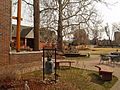
.jpg)

- University of Colorado Boulder: This is a public university. It adds about 46,000 students and staff to the population.
- Naropa University: This is a private university based on Buddhist ideas. It has about 400 undergraduate and over 600 graduate students.
- Auguste Escoffier School of Culinary Arts: This is a cooking school with a campus in Boulder.
Science and Research Centers
Boulder is home to many important science and research institutes. These include:
- Cooperative Institute for Research in Environmental Sciences (CIRES)
- National Center for Atmospheric Research (NCAR)
- National Institute of Standards and Technology (NIST)
- National Oceanic and Atmospheric Administration (NOAA)
- United States Geological Survey (USGS)
These centers study things like weather, climate, space, and the environment.
Media and News
Boulder has its own daily newspaper, the Daily Camera. It started in 1890. The Colorado Daily began in 1892 as a university newspaper. Boulder Magazine is a lifestyle magazine that started in 1978.
Boulder is part of the Denver area for TV stations. It also gets many radio stations from Denver or Fort Collins. The city has its own public TV channel, Boulder 8 TV. It shows city council meetings and local news.
Radio stations in Boulder include:
- KGNU: A non-commercial community radio station founded in 1978.
- KBCO: A commercial music station founded in 1977.
- KVCU (Radio 1190): A non-commercial station run by university students.
- KCFC 1490 AM: Plays NPR programs.
- KRKS-FM 94.7: Offers Christian talk and teaching programs.
Several publishers are also in Boulder. The University of Colorado Press publishes academic books. Paladin Press and Soldier of Fortune magazine also have their headquarters here.
Getting Around Boulder

Many people travel into Boulder for work each day. This is because job growth has been faster than population growth. Boulder is connected by US 36 and other state highways. Parking rules in Boulder try to encourage people to use public transportation.
Boulder has invested a lot in its transportation system. It has many paths for bikes and walkers. These are connected to bike lanes and routes. Boulder also has a community bus network. This connects downtown, the university, and shopping areas. Boulder is known for its great transportation system.
In 2009, Boulder was ranked fourth in the U.S. for the percentage of people who biked to work. In 2013, it was ranked fourth lowest for people who drove alone to work.
Bus Service
Boulder has a large bus system run by the Regional Transportation District (RTD). Routes like HOP, SKIP, JUMP, and DASH run throughout the city. They connect to nearby towns. Buses run every ten minutes during busy times on weekdays. Regional routes connect Boulder to cities like Longmont, Golden, and Denver. There are also buses to Denver International Airport.
Cycling in Boulder
Boulder is famous for its bicycle culture. It has hundreds of miles of paths, lanes, and routes for bikes and walkers. These bikeways can be used all year. Boulder has 74 underpasses for bikes and pedestrians. These help people travel safely without stopping. The city has a website to help people plan bike routes. Boulder has a "Platinum Bicycle Friendly Community" rating.
Warm Showers, a network for cyclists to find places to stay, is based in Boulder. In May 2011, a bike-sharing program called B-cycle started in Boulder. It had 100 bikes and 12 stations.
Airport
Boulder Municipal Airport is about 3 miles (5 km) northeast of central Boulder. The City of Boulder owns it. It's used for small planes and gliders.
Famous People from Boulder
Many notable people have lived in or are from Boulder:
- Albert Allen Bartlett: Physics professor.
- Jello Biafra: Singer for the band Dead Kennedys.
- Scott Carpenter: A Project Mercury astronaut.
- Thomas Cech: Chemist who won a Nobel Prize.
- Joey Diaz: Comedian.
- Allen Ginsberg: Poet who taught at Naropa University.
- Scott Jurek: Ultramarathon runner and writer.
- Kimbal Musk: Entrepreneur and restaurateur.
- Chief Niwot: A tribal leader of the Arapaho people.
- Phil Plait: Astronomer and science blogger.
- Jared Polis: Current Governor of Colorado.
- Joanna Zeiger: Olympic triathlete.
Sister Cities Around the World
Boulder has "sister cities" in different countries. These connections help people learn about other cultures.
- Dushanbe, Tajikistan (1987)
- Jalapa, Nicaragua (1983)
- Kathmandu, Nepal (2018)
- Kisumu, Kenya (2008)
- Lhasa, China (1986)
- El Mante, Mexico (2000)
- Nablus, Palestine (2016)
- Ramat HaNegev, Israel (2018)
- Yamagata, Japan (1994)
- Yateras, Cuba (2002)
You can find landmarks in Boulder that show these connections. The Sister City Plaza was opened in 2007. It honors all of Boulder's sister city relationships. The Dushanbe Tea House on 13th Street was a gift from Dushanbe. It was built in Tajikistan and then moved and rebuilt in Boulder in 1998. A mural representing the connection with Mante, Mexico, was painted by a Mexican artist in 2001. It's at the Dairy Center for the Performing Arts.
Images for kids
-
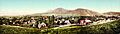
Boulder in 1900
-
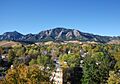
Autumn in Boulder
-
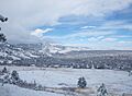
Snowfall is common in Boulder throughout the winter.
-
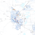
A map of racial distribution in Boulder, 2020 US census. Each dot is one person: ⬤ White ⬤ Black ⬤ Asian ⬤ Hispanic ⬤ Multiracial ⬤ Native American/other
-
"The Hill" is one of the centers of off-campus life for students at the University of Colorado.
-
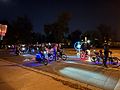
Bicycle riders joining together on Happy Thursday Cruiser Ride
-
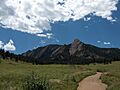
Trailheads for many popular hikes are located at Chautauqua Park.
-
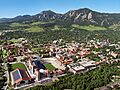
Boulder is home to the University of Colorado Boulder, flagship university of the University of Colorado system.
-
Part of the campus of Naropa University
-
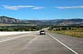
The city from northbound US 36 as the highway descends into Boulder
See also
 In Spanish: Boulder para niños
