
Longmont, Colorado facts for kids
Quick facts for kids
Longmont, Colorado
|
||
|---|---|---|

The Longmont Safety and Justice Center
|
||
|
||

|
||

Longmont, Colorado
Location in the United States
|
||
| Country | ||
| State | ||
| Counties | Boulder County Weld County |
|
| City | Longmont | |
| Founded | 1871 | |
| Incorporated | November 15, 1885 | |
| Named for | Stephen Harriman Long and Longs Peak | |
| Government | ||
| • Type | Home rule municipality | |
| Area | ||
| • Total | 78.74 km2 (30.40 sq mi) | |
| • Land | 74.49 km2 (28.76 sq mi) | |
| • Water | 4.26 km2 (1.64 sq mi) | |
| Elevation | 1,518 m (4,981 ft) | |
| Population
(2020)
|
||
| • Total | 98,885 | |
| • Density | 1,305.70/km2 (3,381.70/sq mi) | |
| Demonym(s) | Longmonter | |
| Time zone | UTC−7 (MST) | |
| • Summer (DST) | UTC−6 (MDT) | |
| ZIP Codes |
80501–80504
|
|
| Area code(s) | 303/720 | |
| FIPS code | 08-45970 | |
| GNIS feature ID | 2410869 | |

Longmont is a city in Colorado, United States. It is located in Boulder and Weld counties. In 2020, about 98,885 people lived there. Longmont is northeast of Boulder. The city is named after Longs Peak, a tall mountain you can see from the city. The word mont means "mountain" in French.
Contents
History of Longmont
Longmont was started in 1871 by a group from Chicago, Illinois. They called themselves the Chicago-Colorado Colony. The group sold memberships to buy land for the town. Longmont was the first planned community in Boulder County. Its streets were laid out in a grid plan, like a checkerboard. The city grew as a farming community after the Colorado Central Railroad arrived in 1877.
In 1925, a group called the Ku Klux Klan took control of Longmont's City Council. They started building a dam called Chimney Rock Dam. They were voted out of office in 1927, and their power soon ended. The dam project was stopped.
In 1955, a plane called United Airlines Flight 629 crashed near Longmont. All 44 people on board died.
During the 1960s, the government built the Denver Air Route Traffic Control Center in Longmont. Also, IBM built a large factory and research center there. Longmont Foods was a company that sold turkey products across the U.S. It closed in 2011. As farming became less important, more technology companies came to Longmont. These included Seagate and Amgen. In 2009, GE Energy moved its control solutions business to the area.
The downtown area along Main Street has become lively again since the 1990s. In the mid-1990s, a new type of community called Prospect New Town was built in Longmont. It was the first "New Urbanist" project in Colorado.
Longmont had Colorado's first library, started in 1871 by Elizabeth Rowell Thompson. Later, a Carnegie library opened in 1913. It closed in 1972 when a new, bigger library opened next door.
In 2013, the Longmont City Council decided to build its own fast internet network. It is called NextLight. This network provides super-fast internet to homes and businesses.
Geography and Climate
Where Longmont Is Located
Longmont is in the northeastern part of Boulder County. It also reaches into western Weld County. U.S. Highway 287 (Main Street) goes through the middle of the city. It leads north to Loveland and south to downtown Denver. State Highway 119 goes through the city south of downtown. It leads southwest to Boulder and east to Interstate 25.
The city hall is about 4,978 feet above sea level. St. Vrain Creek, a small river, flows through the city. It is just south of the city center.
Longmont covers about 71.6 square kilometers. Most of this area is land (67.8 square kilometers). About 3.8 square kilometers, or 5.30%, is water.
Longmont's Weather
Longmont has a cold semi-arid climate. This means it is usually dry with cold winters. The hottest temperature ever recorded in Longmont was 106°F. This happened on July 7, 1973, and June 27, 1994. The coldest temperature was -38°F on January 16, 1930.
| Climate data for Longmont, Colorado, 1991–2020 normals, extremes 1893–present | |||||||||||||
|---|---|---|---|---|---|---|---|---|---|---|---|---|---|
| Month | Jan | Feb | Mar | Apr | May | Jun | Jul | Aug | Sep | Oct | Nov | Dec | Year |
| Record high °F (°C) | 75 (24) |
79 (26) |
85 (29) |
91 (33) |
100 (38) |
106 (41) |
106 (41) |
104 (40) |
101 (38) |
92 (33) |
83 (28) |
78 (26) |
106 (41) |
| Mean maximum °F (°C) | 63.4 (17.4) |
67.0 (19.4) |
74.8 (23.8) |
81.8 (27.7) |
89.2 (31.8) |
97.2 (36.2) |
100.6 (38.1) |
97.8 (36.6) |
94.0 (34.4) |
84.2 (29.0) |
72.2 (22.3) |
64.3 (17.9) |
101.4 (38.6) |
| Mean daily maximum °F (°C) | 44.5 (6.9) |
46.8 (8.2) |
56.8 (13.8) |
63.2 (17.3) |
72.7 (22.6) |
83.9 (28.8) |
90.8 (32.7) |
87.8 (31.0) |
80.3 (26.8) |
66.2 (19.0) |
53.5 (11.9) |
44.8 (7.1) |
65.9 (18.8) |
| Daily mean °F (°C) | 29.4 (−1.4) |
32.0 (0.0) |
41.5 (5.3) |
47.8 (8.8) |
57.1 (13.9) |
67.2 (19.6) |
73.1 (22.8) |
70.8 (21.6) |
63.0 (17.2) |
49.5 (9.7) |
38.5 (3.6) |
29.6 (−1.3) |
50.0 (10.0) |
| Mean daily minimum °F (°C) | 14.4 (−9.8) |
17.1 (−8.3) |
26.1 (−3.3) |
32.3 (0.2) |
41.4 (5.2) |
50.5 (10.3) |
55.4 (13.0) |
53.7 (12.1) |
45.8 (7.7) |
32.9 (0.5) |
23.5 (−4.7) |
14.5 (−9.7) |
34.0 (1.1) |
| Mean minimum °F (°C) | −8.7 (−22.6) |
−3.5 (−19.7) |
6.2 (−14.3) |
17.0 (−8.3) |
30.3 (−0.9) |
40.5 (4.7) |
48.3 (9.1) |
46.3 (7.9) |
30.1 (−1.1) |
18.6 (−7.4) |
3.1 (−16.1) |
−7.7 (−22.1) |
−15.9 (−26.6) |
| Record low °F (°C) | −38 (−39) |
−36 (−38) |
−26 (−32) |
−7 (−22) |
18 (−8) |
29 (−2) |
38 (3) |
37 (3) |
18 (−8) |
−5 (−21) |
−16 (−27) |
−32 (−36) |
−38 (−39) |
| Average precipitation inches (mm) | 0.56 (14) |
0.57 (14) |
1.17 (30) |
2.04 (52) |
1.97 (50) |
1.75 (44) |
1.69 (43) |
1.95 (50) |
1.26 (32) |
1.04 (26) |
0.75 (19) |
0.46 (12) |
15.21 (386) |
| Average snowfall inches (cm) | 5.8 (15) |
3.8 (9.7) |
5.6 (14) |
3.1 (7.9) |
0.2 (0.51) |
0.0 (0.0) |
0.0 (0.0) |
0.0 (0.0) |
0.3 (0.76) |
1.1 (2.8) |
6.1 (15) |
6.2 (16) |
32.2 (81.67) |
| Average precipitation days (≥ 0.01 in) | 3.7 | 4.5 | 5.1 | 7.5 | 10.1 | 8.3 | 6.1 | 7.4 | 6.3 | 5.4 | 4.9 | 3.0 | 72.3 |
| Average snowy days (≥ 0.1 in) | 2.0 | 2.4 | 2.2 | 1.5 | 0.3 | 0.0 | 0.0 | 0.0 | 0.2 | 0.4 | 2.2 | 2.2 | 13.4 |
| Source 1: National Weather Service (mean maxima and minima 1971–2000) | |||||||||||||
| Source 2: NOAA (average snowfall/snowy days 1981–2010) | |||||||||||||
People of Longmont
Population Growth
| Historical population | |||
|---|---|---|---|
| Census | Pop. | %± | |
| 1880 | 773 | — | |
| 1890 | 1,543 | 99.6% | |
| 1900 | 2,201 | 42.6% | |
| 1910 | 4,256 | 93.4% | |
| 1920 | 5,848 | 37.4% | |
| 1930 | 6,029 | 3.1% | |
| 1940 | 7,406 | 22.8% | |
| 1950 | 8,099 | 9.4% | |
| 1960 | 11,489 | 41.9% | |
| 1970 | 23,209 | 102.0% | |
| 1980 | 42,942 | 85.0% | |
| 1990 | 51,555 | 20.1% | |
| 2000 | 71,093 | 37.9% | |
| 2010 | 86,270 | 21.3% | |
| 2020 | 98,885 | 14.6% | |
| U.S. Decennial Census | |||
In 2010, about 86,270 people lived in Longmont. By 2020, the population grew to 98,885. This means about 3,294 people lived in each square mile. There were 35,008 homes in the city.
Diversity in Longmont
Longmont is a diverse city. Here's a look at the different groups of people living there in 2020:
| Race / Ethnicity (NH = Non-Hispanic) | Pop 2000 | Pop 2010 | Pop 2020 | % 2000 | % 2010 | % 2020 |
|---|---|---|---|---|---|---|
| White alone (NH) | 54,599 | 59,772 | 64,916 | 76.80% | 69.28% | 65.65% |
| Black or African American alone (NH) | 363 | 661 | 900 | 0.51% | 0.77% | 0.91% |
| Native American or Alaska Native alone (NH) | 408 | 413 | 447 | 0.57% | 0.48% | 0.45% |
| Asian alone (NH) | 1,236 | 2,696 | 3,490 | 1.74% | 3.13% | 3.53% |
| Pacific Islander alone (NH) | 31 | 40 | 65 | 0.04% | 0.05% | 0.07% |
| Some Other Race alone (NH) | 76 | 108 | 514 | 0.11% | 0.13% | 0.52% |
| Mixed Race or Multi-Racial (NH) | 822 | 1,389 | 4,096 | 1.16% | 1.61% | 4.14% |
| Hispanic or Latino (any race) | 13,558 | 21,191 | 24,457 | 19.07% | 24.56% | 24.73% |
| Total | 71,093 | 86,270 | 98,885 | 100.00% | 100.00% | 100.00% |
In 2010, about 36.9% of homes had children under 18. About 54.6% were married couples. The average household had 2.64 people. The average family had 3.15 people.
About 28.6% of the population was under 20 years old. The average age was 36 years.
The median income for a household was $58,698. This means half of the households earned more, and half earned less. For families, the median income was $70,864. The income per person was $29,209. About 14.7% of the population lived below the poverty line. This includes 21.4% of those under 18.
In 2011, Longmont was ranked the second safest city in Colorado.
Education in Longmont
Longmont has several schools and colleges. It is home to the Boulder County Campus of Front Range Community College. The St. Vrain Valley School District serves the public schools. There are also many private schools.
Longmont has a public library. In 2019, people were discussing if the library should become its own district. The library director said the library needed more resources. She noted it had not grown as fast as the city.
Transportation in Longmont
Longmont offers bus services to Denver and Boulder. These are part of the RTD system. There is also a FLEX regional bus service. It connects Longmont to Fort Collins, Loveland, and Berthoud.
Plans are in place to extend RTD's commuter rail B Line to Longmont. This project, called FasTracks, might be finished in the early 2040s.
In 2012, Longmont was named a "silver-level" bicycle-friendly community. This award came from the League of American Bicyclists. Longmont was one of only 38 cities in the U.S. to get this honor. It was the only city in Colorado at this level that is not a major tourist spot or a university city.
Vance Brand Airport is an airport owned by the city. It does not have regular passenger flights. However, it is popular for smaller private planes.
Media in Longmont
Longmont has local news sources. The Longmont Leader is the local daily newspaper. It used to be called the Longmont Observer.
The Longmont Times-Call also covers the city. However, it is published from Boulder.
Longmont has several radio stations. These include KRCN, KGUD, and KKFN. Sports radio is broadcast on KKSE-FM from a tower nearby. KDFD is also nearby. It is a Fox News Radio station with a conservative talk format.
You can also listen to NPR programs. These are on Colorado Public Radio stations KCFR from Denver and KCFC (AM) in Boulder. KUNC from the Fort Collins-Greeley area can also be heard.
Longmont is also served by Pacifica Radio affiliate KGNU. This is a non-commercial community radio station from Boulder.
Economy of Longmont


Longmont has many different types of businesses. Here are the top employers in the city as of 2020:
| # | Employer | # of Employees |
|---|---|---|
| 1 | St. Vrain Valley Schools | 3,543 |
| 2 | City of Longmont | 1,625 |
| 3 | Seagate Technology | 1,430 |
| 4 | Intrado | 755 |
| 5 | Longmont United Hospital | 671 |
| 6 | UC Health Longs Peak Hospital | 540 |
| 7 | McLane Western | 460 |
| 8 | Federal Aviation Administration | 422 |
| 9 | Circle Graphics | 400 |
| 10 | AveXis | 354 |
Longmont is also known for its many craft breweries. Two of the largest are Left Hand and Oskar Blues. You can take the Brew Hop Trolley to visit them. Longmont is also known for its "maker" community. There is a Saturday Farmers Market too.
Because it is close to Rocky Mountain National Park, Longmont has many hotels and restaurants. These businesses serve tourists visiting the park. Mile Hi Skydiving, one of Colorado's largest skydiving places, is in Longmont. The city is also home to Saul, the World's Largest Sticker Ball. Other businesses support skiing, snowsports, bicycling, and rock climbing.
In 2022, the average household income in Longmont was $89,720 per year. The biggest industries were manufacturing, professional and technical services, and retail trade.
Notable People from Longmont
- Valarie Allman (born 1995), won gold medals in discus at the 2020 and 2024 Olympics. She went to Silver Creek High School.
- Greg Biekert (born 1969), an American football player and coach. He played football for Longmont High School.
- David Bote (born 1993), a Major League Baseball (MLB) player. He was born in Longmont.
- Vance D. Brand (born 1931), a NASA astronaut. He graduated from Longmont High School.
- Elizabeth A. Fenn (born 1959), a historian who won a Pulitzer Prize. She lives in Longmont.
- John R. Kelso (born 1831), a congressman and author. He lived in Longmont.
- Kody Lostroh (born 1985), a Professional Bull Riders World Champion in 2009. He was born in Longmont.
- David Pauley (born 1983), an MLB pitcher. He graduated from Longmont High School.
- Jack Reynor (born 1992), an Irish actor. He was born in Longmont.
- Kristen Schaal (born 1978), a comedian and actress. She grew up in Longmont.
- Dan Simmons (born 1948), an author who won a Hugo Award. He lives in Longmont.
- Kimiko Soldati (born 1974), a diver at the 2004 Olympics. She grew up in Longmont.
- Fred Stone (born 1873), a stage and film actor. He lived in Longmont.
- William Oxley Thompson (born 1855), the fifth President of The Ohio State University. He founded the short-lived Longmont Presbyterian College.
- Ed Werder (born 1960), a sports reporter who won the Dick McCann Award. He went to Longmont High School.
Sister Cities
Longmont has special "sister city" relationships with other places:
 Chino, Nagano, Japan
 Ciudad Guzmán, Jalisco, Mexico
- Northern Arapaho Tribe, Wind River Reservation, Wyoming
Images for kids
-
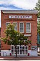
The Longmont Fire Department Station 1 is listed in the National Register of Historic Places.
-

Longmont Public Library
-
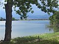
Reservoir west of Longmont
-

Longmont Performing Arts Center
-
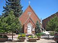
Former St. Stephen's Church (1881) now houses the St. Vrain Historical Society in Longmont.


See also
 In Spanish: Longmont para niños
