
Weld County, Colorado facts for kids
Quick facts for kids
Weld County
|
|
|---|---|

Weld County Courthouse
|
|

Location within the U.S. state of Colorado
|
|
 Colorado's location within the U.S. |
|
| Country | |
| State | |
| Founded | November 3, 1861 |
| Seat | Greeley |
| Largest city | Greeley |
| Area | |
| • Total | 4,017 sq mi (10,400 km2) |
| • Land | 3,987 sq mi (10,330 km2) |
| • Water | 30 sq mi (80 km2) 0.7% |
| Population
(2020)
|
|
| • Total | 328,981 |
| • Density | 83/sq mi (32/km2) |
| Time zone | UTC−7 (Mountain) |
| • Summer (DST) | UTC−6 (MDT) |
| Congressional districts | 2nd, 4th, 8th |
Weld County is a county located in the U.S. state of Colorado. It's in the western part of the United States. In 2020, about 328,981 people lived there. The main city and county seat is Greeley.
Weld County is part of the Greeley area, which is a larger group of cities and towns. This area is also connected to the bigger Denver metropolitan area.
Contents
History of Weld County

Weld County has a long and interesting history. It started way back on May 30, 1854. That's when the Kansas–Nebraska Act created two new areas: the Nebraska Territory and the Kansas Territory. These areas were divided by a line called the 40th Parallel North. Today, this line is known as Baseline Road or County Line Road in Weld County.
The land that is now Weld County was in the southwestern part of the Nebraska Territory. It was right next to the Kansas Territory.
The Gold Rush and New Territories
In July 1858, people found gold along the South Platte River. This started the Pike's Peak Gold Rush. Many miners felt far away from the governments of Kansas and Nebraska. So, they decided to create their own area called the Territory of Jefferson on October 24, 1859.
The leaders of the Jefferson Territory then set up 12 counties. One of these was St. Vrain County. It was named after Ceran de Hault de Lassus de St. Vrain. He was a French trader who built the first trading post on the upper South Platte River. St. Vrain County covered much of what is now Weld County.
The Jefferson Territory was never officially recognized by the U.S. government. But on February 28, 1861, U.S. President James Buchanan signed a law to create the Territory of Colorado.
Weld County is Born
On November 1, 1861, the Colorado leaders created 17 counties for the new Colorado Territory. Weld County was one of them! It was named after Lewis Ledyard Weld. He was a lawyer and a secretary for the territory. He sadly passed away while serving in the army during the Civil War.
For many years, Weld County was much larger than it is today. Its borders included areas that are now Washington County, Logan County, Morgan County, Yuma County, Phillips County, and Sedgwick County. These areas became separate counties on February 9, 1887.
Important Events
On November 1, 1955, a plane called United Airlines Flight 629 crashed in Weld County. It was flying from Denver to Portland, Oregon. All 44 people on board died. The investigation found that a bomb had been placed on the plane. Parts of the plane and other items were spread over a large area.
Weld County is also known for having many tornado sightings. From 1950 to 2011, it had 252 confirmed tornadoes. That's more than any other county in the U.S.!
On March 6, 2019, Weld County declared itself a "Second Amendment sanctuary." This means the county supports the right to own guns.
Ideas to Leave Colorado
In 2013, some leaders in Weld County wanted to leave the state of Colorado. They wanted to create a new state. Voters in Weld County and other nearby counties voted on this idea in November 2013. Six out of 11 counties voted no, including Weld County. Five counties voted yes.
Even though the idea didn't pass, the leaders said they would keep looking at the differences between city and country areas in Colorado.
In 2021, a group called "Weld County, WY" started a new idea. They wanted Weld County to leave Colorado and join Wyoming. This was because of political differences between the county and the state government. The Governor of Wyoming, Mark Gordon, said he would "love that." But Colorado Governor Jared Polis replied, "Hands off Weld County."
Geography of Weld County


Weld County is a very large county. It covers about 4,017 square miles. Most of this is land, with a small amount of water. It is the third-largest county in Colorado by size.
The county is mostly flat in the eastern part of Colorado. In the northeastern areas, you can find the large Pawnee National Grassland. This area has unique rock formations called the Pawnee Buttes. These buttes rise about 350 feet above the land. They are surrounded by small canyons. Along the western edge of the county, you can see hills. These hills are the start of the Rocky Mountains further west.
Main Roads
Two major interstate highways cross Weld County:
 Interstate 25 runs through the southwestern part.
 Interstate 76 goes from the south-central edge northeast.
Other important roads include:
 U.S. Highway 34
 U.S. Highway 85
 U.S. Highway 87
 State Highway 14
Neighboring Counties
Weld County shares borders with several other counties:
- Kimball County, Nebraska - to the northeast
- Logan County - to the east
- Morgan County - to the east
- Adams County - to the south
- City and County of Broomfield - to the southwest
- Boulder County - to the west
- Larimer County - to the west
- Laramie County, Wyoming - to the northwest
Public Transportation
- Greeley-Evans Transit
- Express Arrow
Nature Areas
- Pawnee National Grassland is a large protected area.
- Fort Vasquez State History Museum
- St. Vrain State Park
Trails and Paths
- American Discovery Trail
- Pawnee Pioneer Trails
- Poudre River National Recreation Trail
- South Platte Trail
Population and People
| Historical population | |||
|---|---|---|---|
| Census | Pop. | %± | |
| 1870 | 1,636 | — | |
| 1880 | 5,646 | 245.1% | |
| 1890 | 11,736 | 107.9% | |
| 1900 | 16,808 | 43.2% | |
| 1910 | 39,177 | 133.1% | |
| 1920 | 54,059 | 38.0% | |
| 1930 | 65,097 | 20.4% | |
| 1940 | 63,747 | −2.1% | |
| 1950 | 67,504 | 5.9% | |
| 1960 | 72,344 | 7.2% | |
| 1970 | 89,297 | 23.4% | |
| 1980 | 123,438 | 38.2% | |
| 1990 | 131,821 | 6.8% | |
| 2000 | 180,936 | 37.3% | |
| 2010 | 252,825 | 39.7% | |
| 2020 | 328,981 | 30.1% | |
| 2023 (est.) | 359,442 | 42.2% | |
| U.S. Decennial Census 1790-1960 1900-1990 1990-2000 2010-2020 |
|||
Weld County has grown a lot over the years. In 2000, there were about 180,936 people living there. By 2020, the population had grown to 328,981. This shows that many people are choosing to live in Weld County.
The average age of people in the county in 2000 was 31 years old.
Economy
Weld County is very important for Colorado's economy. It is the top producer of cattle, grain, and sugar beets in the state. It's also known as the richest farming county in the United States east of the Rocky Mountains. Overall, it's the fourth richest farming county in the whole country!
The county is also becoming a major area for producing milk. Nearly half of all the cattle in Colorado are found here. Besides farming, Weld County is important for oil and natural gas production.
Communities

Weld County has many different cities, towns, and smaller communities.
Cities
- Brighton‡
- Dacono
- Evans
- Fort Lupton
- Greeley
- Longmont‡
- Northglenn‡
- Thornton (part)‡
Towns
- Ault
- Berthoud ‡
- Eaton
- Erie‡
- Firestone
- Frederick
- Garden City
- Gilcrest
- Grover
- Hudson
- Johnstown‡
- Keenesburg
- Kersey
- LaSalle
- Lochbuie‡
- Mead
- Milliken
- Nunn
- Pierce
- Platteville
- Raymer
- Severance
- Windsor‡
Census-designated places
These are areas that are like towns but are not officially incorporated.
Unincorporated communities
These are smaller places that don't have their own local government.
- Auburn
- Avalo
- Buda
- Carr
- Dearfield
- Galeton (originally called "Zita")
- Gill
- Hereford
- Highlandlake
- Ione
- Keota
- Lucerne
- Roggen
- Stoneham
- Wattenburg
Ghost towns
These are towns that used to exist but are now abandoned.
- Adna
- Agricola
- Chapelton
- Chenoa
- Cherokee City
- Cloverly
- Coleman
- Dearfield
- Elwell
- Flemings Ranch
- Fort St. Vrain
- Fosston
- Gault
- Geary
- Graham
- Green City
- Highland Lake
- Hillsborough
- Hiltonville
- Hungerford
- Ione
- Kalous
- Kauffman
- Koenig
- Lancaster
- Latham
- Liberty
- Masters
- Nantes
- New Liberty
- Osgood
- Peckham
- Platte Valley
- Raymer
- Rinn
- Rosedale
- Saint Vrain
- Serene
- Sligo
- Spanish Colony
- Wentz
- Zilar
- Zita
‡ means a populated place has parts in a county next to Weld County.
Education
Weld County has many school districts that serve its students:
- Ault-Highland School District RE-9
- Briggsdale School District RE-10
- Eaton School District RE-2
- Greeley School District 6
- Johnstown-Milliken School District RE-5J
- Pawnee School District RE-12
- Platte Valley School District RE-7
- Prairie School District RE-11
- School District 27J
- St. Vrain Valley School District RE 1J
- Thompson School District R-2J
- Weld County School District RE-1
- Weld County School District RE-3J
- Weld County School District RE-8
- Weldon Valley School District RE-20J
- Wiggins School District RE-50J
- Windsor School District RE-4
Images for kids
-
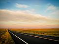
Sunrise over the Pawnee National Grassland in northeastern Weld County.

See also
 In Spanish: Condado de Weld para niños
