
Hudson, Colorado facts for kids
Quick facts for kids
Town of Hudson
|
|
|---|---|

The Hudson Town Hall.
|
|

Location of Hudson in Weld County, Colorado.
|
|
| Country | |
| State | |
| County | Weld |
| Incorporated (town) | April 2, 1914 |
| Government | |
| • Type | Statutory Town |
| Area | |
| • Total | 5.96 sq mi (15.43 km2) |
| • Land | 5.88 sq mi (15.23 km2) |
| • Water | 0.08 sq mi (0.20 km2) |
| Elevation | 5,000 ft (1,524 m) |
| Population
(2020)
|
|
| • Total | 1,651 |
| • Density | 277.0/sq mi (107.00/km2) |
| Time zone | UTC-7 (MST) |
| • Summer (DST) | UTC-6 (MDT) |
| ZIP code |
80642
|
| Area code(s) | 303 |
| FIPS code | 08-37820 |
| GNIS feature ID | 0180861 |
| Website | Town of Hudson |
The Town of Hudson is a small town in Weld County, Colorado, United States. It is a special type of town called a home rule municipality. This means it has its own local government that can make many of its own rules.
In 2020, about 1,651 people lived in Hudson. The town is named after the Hudson City Land and Improvement Company. A post office has been open in Hudson since 1883.
Where is Hudson Located?
Hudson is found in Colorado, at these coordinates: 40°4′21″N 104°38′24″W / 40.07250°N 104.64000°W. It is about 5,000 feet (1,524 meters) above sea level.
The town covers a total area of about 2.3 square miles (5.96 square kilometers). Most of this area is land, with a very small part being water.
How Many People Live in Hudson?
The number of people living in Hudson has changed over the years. Here's a look at the population counts from different U.S. Censuses:
| Historical population | |||
|---|---|---|---|
| Census | Pop. | %± | |
| 1920 | 322 | — | |
| 1930 | 346 | 7.5% | |
| 1940 | 295 | −14.7% | |
| 1950 | 365 | 23.7% | |
| 1960 | 430 | 17.8% | |
| 1970 | 518 | 20.5% | |
| 1980 | 698 | 34.7% | |
| 1990 | 918 | 31.5% | |
| 2000 | 1,565 | 70.5% | |
| 2010 | 2,356 | 50.5% | |
| 2020 | 1,651 | −29.9% | |
Images for kids
-
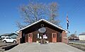
The Hudson Town Hall building.
-
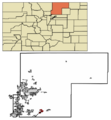
A map showing where Hudson is located in Weld County, Colorado.
See also
 In Spanish: Hudson (Colorado) para niños
