
Kimball County, Nebraska facts for kids
Quick facts for kids
Kimball County
|
|
|---|---|

Kimball County Courthouse in Kimball
|
|

Location within the U.S. state of Nebraska
|
|
 Nebraska's location within the U.S. |
|
| Country | |
| State | |
| Founded | 1888 |
| Seat | Kimball |
| Largest city | Kimball |
| Area | |
| • Total | 952 sq mi (2,470 km2) |
| • Land | 952 sq mi (2,470 km2) |
| • Water | 0.6 sq mi (2 km2) 0.06%% |
| Population
(2020)
|
|
| • Total | 3,434 |
| • Estimate
(2022)
|
3,315 |
| • Density | 3.6071/sq mi (1.3927/km2) |
| Time zone | UTC−7 (Mountain) |
| • Summer (DST) | UTC−6 (MDT) |
| Congressional district | 3rd |
Kimball County is a county located in the state of Nebraska in the United States. In 2020, about 3,434 people lived there. The main town and government center is Kimball. The county was created in 1888. It was named after Thomas Lord Kimball, who was important in building railroads. When Nebraska started its license plate system in 1922, Kimball County was given the number 71. This was because it had the 71st largest number of vehicles registered in the state at that time.
Contents
Exploring Kimball County's Geography
Kimball County's land has gentle, rolling hills that slope towards the east. The flatter parts of the county are mostly used for farming. Farmers often use a method called dry farming, which means they grow crops without extra water from irrigation. Some areas also use center pivot irrigation, which is a way to water crops using a large rotating sprinkler system.
A small stream called Lodgepole Creek flows into the Oliver Reservoir. This reservoir is located in the western-central part of the county. Kimball County covers a total area of about 952 square miles (2,466 square kilometers). Almost all of this area is land, with only a tiny bit (0.06%) being water.
Nebraska's Highest Point
Kimball County is home to Panorama Point. This is the highest natural spot in all of Nebraska! It stands at 5,424 feet (1,653 meters) above sea level.
Major Roads in Kimball County
Several important highways pass through Kimball County, making it easy to travel.
 Interstate 80
 U.S. Highway 30
 Nebraska Highway 71
Neighboring Counties
Kimball County shares its borders with several other counties:
- Banner County – to the north
- Cheyenne County – to the east
- Logan County, Colorado – to the southeast
- Weld County, Colorado – to the southwest
- Laramie County, Wyoming – to the west
Protected Natural Areas
One special place in Kimball County is the Oliver Reservoir State Recreation Area. It is a protected area where people can enjoy nature and outdoor activities.
Kimball County's Population Over Time
| Historical population | |||
|---|---|---|---|
| Census | Pop. | %± | |
| 1890 | 959 | — | |
| 1900 | 758 | −21.0% | |
| 1910 | 1,942 | 156.2% | |
| 1920 | 4,498 | 131.6% | |
| 1930 | 4,675 | 3.9% | |
| 1940 | 3,913 | −16.3% | |
| 1950 | 4,283 | 9.5% | |
| 1960 | 7,975 | 86.2% | |
| 1970 | 6,009 | −24.7% | |
| 1980 | 4,882 | −18.8% | |
| 1990 | 4,108 | −15.9% | |
| 2000 | 4,089 | −0.5% | |
| 2010 | 3,821 | −6.6% | |
| 2020 | 3,434 | −10.1% | |
| 2022 (est.) | 3,315 | −13.2% | |
| US Decennial Census 1790-1960 1900-1990 1990-2000 2010 2020 2022 |
|||
In 2000, there were 4,089 people living in Kimball County. The population density was about 4 people per square mile. Most of the people living in the county were White (96.99%). A small number of people were from other racial backgrounds. About 3.33% of the population identified as Hispanic or Latino.
The median age in the county in 2000 was 43 years old. This means half the people were younger than 43, and half were older. About 24.7% of the population was under 18 years old.
Towns and Villages in Kimball County
Kimball County has a few communities where people live and work.
City
- Kimball (This is the largest city and the county seat, meaning it's where the county government is located.)
Villages
Unincorporated Communities
These are smaller communities that are not officially organized as cities or villages.
Images for kids
-
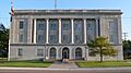
The Kimball County Courthouse in Kimball.
See also
 In Spanish: Condado de Kimball para niños
